Sunday night brought an unsettling tremor to parts of Mindanao when a tectonic earthquake with a magnitude of 5.0 struck off the coast of Surigao del Sur, with shaking clearly felt by residents inside their homes in Tandag City. The Philippine Institute of Volcanology and Seismology of the Department of Science and Technology (PHIVOLCS-DOST) confirmed the event through its official bulletin.
Time, Location, and Origin of the Earthquake
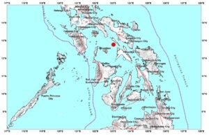
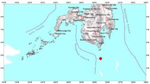
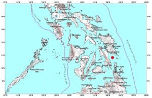
According to PHIVOLCS-DOST, the tremor struck at precisely 9:19:01 in the evening, Philippine Standard Time (PHT), on Sunday, May 24, 2026. The earthquake’s epicenter was pinpointed approximately 57 kilometers in the direction of north 66° east of Bayabas, Surigao del Sur, placing its geographic coordinates at 9.18°N, 126.75°E.
PHIVOLCS-DOST further noted that the earthquake originated at a shallow focal depth of only 10 kilometers beneath the Earth’s surface. The agency classified the event as tectonic in nature — that is, generated by the shifting and movement of geological fault structures rather than by any volcanic process. Shallow earthquakes such as this one tend to produce stronger surface shaking relative to their magnitude compared to deeper events.
Intensity Levels Recorded Across Affected Areas
The most significant shaking was reported in Tandag City, the capital of Surigao del Sur, where the earthquake registered at Intensity III on the PHIVOLCS Earthquake Intensity Scale (PEIS), as reported by PHIVOLCS-DOST. Intensity III shaking is generally described as perceptible to many individuals who are indoors at the time, with vibrations often likened to the rumbling sensation caused by a light truck passing nearby. Hanging objects and light fixtures may visibly sway, and some people may be roused from light sleep.
Meanwhile, in Nabunturan, Davao de Oro, the earthquake was registered at only an instrumental Intensity I, according to the same PHIVOLCS-DOST bulletin. At this level, the tremor was too faint to be felt by humans and was detectable only through sensitive seismological instruments stationed in the area. No perceptible shaking was experienced by residents there.
No Damage Expected, but Aftershocks Remain Possible
Despite the earthquake’s magnitude, PHIVOLCS-DOST assessed that no structural damage is expected as a result of the event. The agency’s assessment is based on the intensity readings gathered from affected localities, none of which reached the threshold typically associated with physical damage to structures or infrastructure.
However, PHIVOLCS-DOST cautioned that aftershocks may still follow in the hours or days after the main event. Residents in the affected areas are advised to remain alert and to stay informed through official government channels. Authorities routinely issue such reminders following tectonic earthquakes of this magnitude, particularly when the focus is shallow.
Bulletin Details and Monitoring Information
The official earthquake bulletin covering this event was formally released by PHIVOLCS-DOST at 9:54 PM PHT on May 24, 2026 — roughly 35 minutes after the earthquake was registered. The agency designated the publication as Earthquake Information No. 2 for this event.
PHIVOLCS-DOST stated that the bulletin issued is expected to be the final one for this seismic event, unless new or additional data emerges that would warrant further reporting. An epicentral map depicting the exact location of the earthquake’s origin is accessible through the agency’s official bulletin page.
The public is encouraged by PHIVOLCS-DOST to monitor its official website for any updates on seismic activity across the country. The agency’s real-time earthquake monitoring portal can be accessed at phivolcs.dost.gov.ph, where bulletins, intensity maps, and historical earthquake data are made available to the general public.
Background: Earthquake Activity in Mindanao
The Mindanao region, which includes Surigao del Sur, sits within the seismically active zone shaped by several major fault systems and tectonic plate boundaries converging in and around the Philippine archipelago. The Philippines lies along the Pacific Ring of Fire, making it one of the most earthquake-prone countries in the world. Tectonic events in shallow-depth zones, such as this magnitude 5.0 earthquake, are not uncommon in the region and are closely monitored by PHIVOLCS-DOST on a continuous basis.
Residents living near active fault zones are consistently reminded by the agency to practice earthquake preparedness measures — including securing heavy furniture, identifying safe spots within structures, and keeping emergency kits readily available. These precautions are especially important in communities that experience frequent low-to-moderate seismic activity.
For immediate updates following any earthquake event, PHIVOLCS-DOST remains the primary and authoritative government body responsible for seismic monitoring and public information dissemination in the Philippines.
Originally reported by: wire reports