Early Monday morning brought seismic activity to the waters surrounding Aurora province as a 4.4-magnitude earthquake generated mild tremors across several coastal communities, according to the Philippine Institute of Volcanology and Seismology (PHIVOLCS-DOST). The offshore tremor, while noticeable to residents in affected areas, presents no risk of structural damage or property destruction.
Seismic Event Specifics
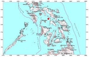
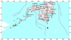
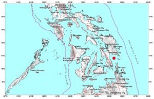
PHIVOLCS recorded the tectonic earthquake at precisely 5:07 AM Philippine Standard Time on April 21, 2026. The seismic event’s epicenter was pinpointed 19 kilometers southwest of Dinalungan, Aurora, occurring at geographical coordinates 16.1°N, 121.79°E. The tremor originated at a depth of 12 kilometers below the ocean floor, classifying it as a relatively shallow earthquake.
The timing and location of this seismic activity placed it within the frequently monitored waters off Aurora’s coastline, an area subject to regular tectonic movements due to the complex geological formations beneath the Philippine archipelago.
Intensity Measurements Across Aurora Communities
Seismological instruments operated by PHIVOLCS documented varying levels of ground movement throughout Aurora province during the earthquake. Casiguran experienced the strongest recorded intensity at Level II, which represents slightly perceptible shaking that sensitive individuals or people in resting positions might detect.
Meanwhile, the municipalities of Baler and San Luis registered weaker Intensity I movements on PHIVOLCS monitoring equipment. This classification indicates barely detectable motion that typically remains unnoticed except under optimal conditions or by particularly sensitive observers.
The graduated intensity levels across these Aurora communities reflect the earthquake’s offshore origin and the natural dissipation of seismic energy as it travels through different geological materials from the epicenter to populated areas.
Official Assessment and Damage Evaluation
Following comprehensive analysis of the seismic data, PHIVOLCS scientists concluded that Monday’s earthquake poses no threat to infrastructure, buildings, or personal property throughout the affected region. The magnitude and depth characteristics of this particular tremor fall well below thresholds typically associated with structural damage.
The government seismology agency also determined that this earthquake is unlikely to produce aftershocks, providing reassurance to residents who may have felt the morning’s tremor. This assessment represents standard protocol for earthquakes of similar magnitude and origin characteristics.
Communication and Public Information
PHIVOLCS released its official earthquake bulletin at 6:28 AM PHT, approximately one hour and twenty minutes following the seismic event. This bulletin contains the agency’s complete evaluation of the earthquake’s characteristics, impact, and implications for public safety.
According to established PHIVOLCS procedures, this initial bulletin represents the final official communication regarding the earthquake unless additional significant information emerges or circumstances change. The agency maintains this approach to ensure accurate, verified information reaches the public while avoiding unnecessary alarm.
Understanding Tectonic Earthquakes
PHIVOLCS scientists identified Monday’s tremor as tectonic in nature, distinguishing it from volcanic or other seismic origins. Tectonic earthquakes occur when accumulated stress along geological fault systems exceeds the strength of surrounding rock formations, causing sudden movement and energy release.
This natural process involves the shifting of massive rock formations along existing fractures or fault lines within the Earth’s crust. Unlike volcanic earthquakes, which stem from magma movement or volcanic processes, tectonic events result purely from geological stress and structural adjustments in crustal formations.
The Philippines’ location within the tectonically active Pacific Ring of Fire means such seismic events occur regularly as part of ongoing geological processes affecting the entire archipelago.
Continued Monitoring and Resources
PHIVOLCS maintains continuous seismic monitoring throughout the Philippines, including the waters surrounding Aurora province where Monday’s earthquake occurred. This comprehensive surveillance system enables rapid detection, analysis, and public notification of earthquake activity across the nation.
Citizens seeking official earthquake information and updates can access current PHIVOLCS data and bulletins through the agency’s official website at phivolcs.dost.gov.ph, which provides real-time seismic monitoring information and educational resources about earthquake preparedness and safety.