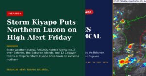
Wet and stormy conditions are set to sweep across Negros Oriental and the rest of the Visayas on Wednesday, June 10, 2026, with the state weather bureau flagging intermittent rainshowers and thunderstorms for much of the day. Residents, farmers, fisherfolk, and commuters are all urged to take precautions as unsettled weather is expected to persist well into the coming days.
PAGASA’s Official Forecast for June 10
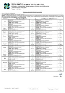
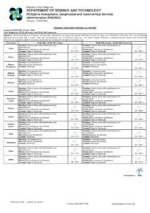
The Philippine Atmospheric, Geophysical and Astronomical Services Administration (PAGASA) released its Visayas regional weather forecast at 5:00 AM on June 10, 2026, projecting partly cloudy to at times overcast skies across the region. The agency specifically cited the likelihood of rainshowers and thunderstorms developing at various points during the day — conditions that, while not classified as extreme or catastrophic, still call for vigilance from the general public.
According to PAGASA, winds are blowing from the southwest to south at light to moderate speeds — a pattern consistent with the ongoing southwest monsoon season, commonly referred to in Filipino as habagat. This seasonal wind system funnels moist ocean air inland, raising the probability of thunderstorm activity especially during the afternoon and early evening hours. Coastal conditions have been assessed as slight to moderate.
Temperatures across the Visayas today are forecast by PAGASA to range between a low of 27°C and a high of 34°C. The heat during dry intervals will be considerable, meaning outdoor workers and event-goers face a double challenge — the discomfort of high humidity and heat during brief clear spells, followed by sudden downpours and lightning when storms roll in.
Areas Covered: Negros Oriental, Siquijor, and Beyond
The PAGASA forecast zone covers the entire Visayas region, with Negros Oriental falling squarely within its scope. Specific areas in the province expected to experience these conditions include the cities of Dumaguete and Bayawan, and the municipalities of Bais, Tanjay, and Guihulngan. Low-lying and coastal communities along the province’s coastline are particularly susceptible to afternoon storm buildup driven by the southwest monsoon.
The island province of Siquijor, located just south of Negros Oriental across the Tanon Strait, falls under the same forecast zone. Residents and visitors there can expect similar weather — partly cloudy to overcast skies punctuated by scattered showers and the occasional thunderstorm throughout the day.
Sea Conditions and Advisory for Fisherfolk
PAGASA described coastal waters around the region as being in slight to moderate condition on June 10. For fishing communities operating from ports and shorelines across Negros Oriental — including Dumaguete port, Tambobo Bay in Siaton, and coastal barangays in Ayungon and Bindoy — this means the sea is navigable but requires careful attention.
Fisherfolk operating smaller motorized bancas are specifically cautioned to exercise heightened care, particularly during afternoon hours when thunderstorms tend to be most intense and unpredictable. Experienced fishermen aboard larger vessels may find conditions manageable, but all those venturing offshore are advised to heed PAGASA’s coastal bulletins before setting out.
Passengers relying on inter-island ferry services — such as OceanJet and other fast craft routes linking Dumaguete to Cebu, Siquijor, and other Visayas ports — may experience some vessel movement under slight to moderate sea conditions. These conditions generally fall within safe operational limits, but travelers are encouraged to check directly with their shipping lines for any updated advisories before departure, as weather can shift quickly throughout the day.
Multi-Day Outlook: Rain to Continue Through Thursday
Beyond Wednesday, PAGASA’s extended weather outlook — issued at 9:00 AM on June 9, 2026 — projects that unsettled conditions will persist across the Visayas through at least Thursday, June 12.
Wednesday and Thursday are both forecast to carry temperatures between 26°C and 33°C, a slight dip from Tuesday’s 27°C to 34°C range. Wind direction is expected to shift marginally from southwest-to-south on Wednesday to southwest-to-southeast by Thursday, though speeds are anticipated to remain light to moderate throughout. Coastal conditions during this extended period are also projected to stay at slight to moderate levels.
This sustained weather pattern means that communities across Negros Oriental should be prepared for recurring bouts of rain and storm activity on multiple consecutive days. Farmers in the highland areas of Guihulngan and the Cuernos de Negros mountain range, as well as those in lowland agricultural zones in Bais and Manjuyod, are advised to factor the possibility of prolonged wet weather into their work schedules for the rest of the week.
Guidance for Farmers in Negros Oriental
For agricultural workers across the province, the southwest monsoon rains carry both benefits and hazards. Crops that need regular moisture during the growing season may benefit from the wet weather, according to the PAGASA forecast pattern. However, the agency’s warning of possible thunderstorms means that field work should be suspended whenever storms are approaching. Farmers in low-lying areas near rivers, drainage channels, or flood-prone zones are also urged to monitor their fields closely for signs of water accumulation or flash flooding.
Reminders for Students, Commuters, and Event Organizers
Parents and students in Negros Oriental should take note that afternoon thunderstorms may coincide with school dismissal hours, making it advisable to have rain gear or other shelter arrangements ready. Commuters traveling by motorcycle, tricycle, or open-air vehicles between municipalities should be aware that wet roads and reduced visibility during heavy downpours can increase road hazards. Mountain routes connecting Dumaguete to interior towns such as Valencia and Sibulan are known to become slippery during intense rain spells.
Organizers of outdoor community activities, public programs, or sports events scheduled for Wednesday are advised to have backup contingency plans, as rainshowers may develop with little notice at any point during the day.
Local Government Units and Emergency Preparedness
The Dumaguete City Disaster Risk Reduction and Management Office (CDRRMO) and the Provincial Disaster Risk Reduction and Management Office (PDRRMO) of Negros Oriental are encouraged to keep close watch on PAGASA advisories throughout the day and the coming days for any updated guidance that may affect public safety protocols or emergency response decisions.
PAGASA issues its Visayas regional weather forecast twice daily, making it the primary reference for weather-related planning across the region. The agency’s official bulletins are available at pagasa.dost.gov.ph, where residents, local officials, and the public can access the most current forecasts and special weather advisories.
The state weather bureau reminded the public that conditions may evolve quickly, particularly during the peak afternoon hours when convective storms are most likely to form along the coast and over higher terrain. Staying informed through official PAGASA channels remains the most reliable way to plan safely during the southwest monsoon season.
Originally reported by: breakingnewsnegrosoriental.com