Not a single province in the Philippines will be spared from wet weather this Friday, June 12, 2026, as the Philippine Atmospheric, Geophysical and Astronomical Services Administration (PAGASA) issues its 24-hour public weather forecast covering the period from 4:00 AM on June 12 through 4:00 AM on June 13. The agency cautions the public that severe thunderstorms may trigger flash floods and landslides in various parts of the country, making weather awareness essential for all Filipinos on Independence Day.
Two atmospheric factors are responsible for the widespread unsettled conditions. The easterlies — a steady eastward-to-westward wind flow originating from the Pacific Ocean — are directly influencing the eastern portions of Southern Luzon, the Visayas, and Mindanao. Meanwhile, localized thunderstorm activity driven by daytime heat and high humidity will generate rain across the rest of the archipelago, including Metro Manila. PAGASA confirmed that no tropical cyclone is currently active within or near the Philippine Area of Responsibility.
Country-Wide Forecast: No Dry Zones Expected
According to PAGASA, the overall weather picture for June 12 is one of widespread cloudiness and intermittent rain. The easterlies dominate the country’s eastern flank, while heat-driven convective thunderstorms account for rainfall across interior and western areas. In effect, every region of the Philippines faces at least some probability of rain before the day ends.
The agency advises the public that when thunderstorms intensify, the danger of flash flooding — particularly in low-lying urban zones with inadequate drainage — rises sharply. Communities on hillsides, slopes, and areas adjacent to mountain ranges face heightened landslide risk during prolonged or heavy downpours.
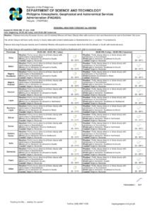
Luzon: Thunderstorms from the Ilocos Coast to Bicol
Metro Manila, the Ilocos Region, Cagayan Valley, Central Luzon, CALABARZON, MIMAROPA, and the Cordillera Administrative Region will all experience partly cloudy to cloudy skies with isolated rainshowers or thunderstorms, PAGASA said. The trigger for these areas is localized thunderstorm development — the kind that builds gradually through the morning and typically reaches peak intensity during the afternoon and early evening hours.
Metro Manila residents, in particular, are urged to take note of the urban heat island effect, which can cause thunderstorm cells to become more intense over the metropolitan area. Sudden, heavy downpours may cause localized flooding in low-lying barangays and areas historically prone to drainage overflow. Commuters should plan for possible delays during the afternoon rush hour, when storm activity is most likely to be at its strongest.
For Extreme Northern Luzon, including Batanes and the northernmost sections of the Ilocos coast, winds will come from the south to southwest at light to moderate speeds. PAGASA forecasts coastal wave heights of 0.6 to 1.5 meters in these waters — classified as slight to moderate — and small vessel operators and fisherfolk are advised to exercise caution before departing.
The Bicol Region, directly exposed to the Pacific and squarely under the influence of the easterlies, carries one of the higher rain probabilities for the day. PAGASA forecasts partly cloudy to cloudy skies with isolated rainshowers or thunderstorms for the region, and specifically highlights the flash flood and landslide hazard for mountainous provinces including Camarines Sur, Albay, and Sorsogon.
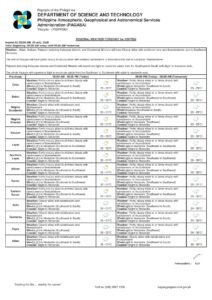
Visayas: Eastern Areas Bear the Brunt of Easterly Winds
A distinction exists between the eastern and western halves of the Visayas on June 12. Eastern Visayas — encompassing Samar, Eastern Samar, Northern Samar, and Leyte — is directly in the path of the easterlies and will experience partly cloudy to cloudy skies with isolated rainshowers or thunderstorms, according to PAGASA. Flash floods and landslides are flagged as real risks in this sub-region, especially in areas near river systems and elevated terrain.
Western Visayas and Central Visayas, including the urban centers of Cebu, Iloilo, and Bacolod, fall under the localized thunderstorm forecast. Residents can expect a pattern similar to Metro Manila — morning cloud cover with the potential for isolated but potentially intense afternoon storms.
Across Palawan and the Visayas, winds will blow from the southeast to northeast at light to moderate intensity. Coastal wave heights are projected at 0.6 to 1.2 meters, which PAGASA categorizes as slight to moderate. Sea travel is generally manageable, though mariners are reminded to stay vigilant for rapid changes in conditions when thunderstorms develop nearby.
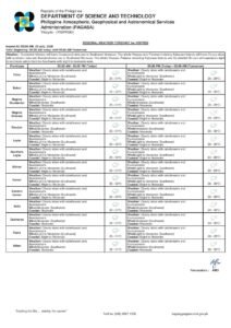
Mindanao: Caraga and Davao Regions in the Easterly Zone
In Mindanao, Caraga and the Davao Region — situated along the island’s eastern seaboard facing the Philippine Sea — will experience the most direct easterly influence. PAGASA’s forecast for both regions calls for partly cloudy to cloudy skies with isolated rainshowers or thunderstorms, along with the standard flash flood and landslide advisory that accompanies all easterly-affected areas.
The remaining portions of Mindanao — Northern Mindanao, Soccsksargen, the Zamboanga Peninsula, and the Bangsamoro Autonomous Region in Muslim Mindanao (BARMM) — will see isolated rainshowers and thunderstorms produced by localized convective activity. PAGASA emphasizes that these areas, while not directly in the easterly zone, are still susceptible to severe weather episodes and residents should not let their guard down.
Winds over Mindanao will blow from the southeast to northeast at light to moderate speeds, and coastal wave heights around the island are projected at 0.6 to 1.2 meters, consistent with easterly flow patterns.
Heat and Humidity: Warm Despite the Rain
Cloudy skies and afternoon showers will do little to bring meaningful relief from the heat. PAGASA’s weather station at the Science Garden in Diliman, Quezon City recorded temperatures for the 24-hour period ending 8:00 PM the previous day: a daytime high of 34.6°C recorded at 2:00 PM and an overnight low of 26.2°C at 5:00 AM. Relative humidity swung between 59% and 90% during that period, reflecting the sticky, oppressive feel characteristic of the Philippine wet season.
A similar temperature profile is expected on June 12, the agency said. Filipinos with outdoor plans are advised to complete activities in the morning and move indoors before noon, as the likelihood of thunderstorm development increases substantially in the early-to-mid afternoon.
Tidal Predictions for Manila Bay
PAGASA, citing data from the National Mapping and Resource Information Authority (NAMRIA), provides the following tidal schedule for Manila Bay on June 12:
- High tide: 1.03 meters at 7:11 AM
- Low tide: 0.14 meters at 2:56 PM
- High tide: 0.46 meters at 9:22 PM
- Low tide: 0.43 meters at 11:39 PM
The sun will rise at 5:27 AM and set at 6:25 PM today. The moon rises at 2:17 AM and sets at 3:24 PM, with lunar illumination of only 11%. The near-absence of moonlight means visibility at sea will be significantly reduced after sunset, and mariners operating at night are advised to take extra precautions.
Public Safety Advisories
PAGASA reiterates that all Filipinos should treat any thunderstorm warning seriously, regardless of whether their area is in an easterly-affected zone or under a localized thunderstorm forecast. The agency recommends avoiding flooded roads, steering clear of riverbanks and slopes during heavy rain, and staying updated through official PAGASA bulletins and local government announcements throughout the day.
Fisherfolk, small boat operators, and coastal communities across all three major island groups are reminded to monitor sea conditions closely and defer sea travel if conditions deteriorate. For those in high-risk flood and landslide zones, pre-emptive evacuation coordination with local disaster risk reduction offices is encouraged whenever thunderstorm warnings are raised.
Originally reported by: wire reports