Skies over Negros Oriental and the rest of the Visayas region are set to turn wet and stormy on Monday, June 8, 2026, with the Philippine Atmospheric, Geophysical and Astronomical Services Administration (PAGASA) issuing an early-morning forecast that calls for intermittent rain showers and thunderstorms developing at various points throughout the day. The forecast, released at 5:00 AM on Monday, signals the kind of unsettled weather that commonly marks the active rainy season across the island region — affecting daily routines for commuters, fisherfolk, farmers, and inter-island travelers alike.
Monday Weather Conditions for Negros Oriental
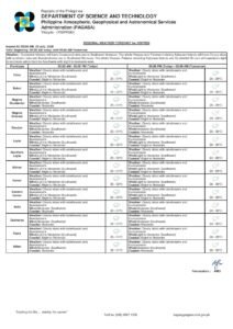
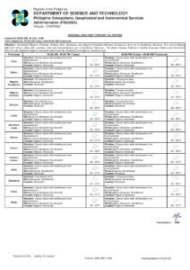
Based on the PAGASA Visayas Regional Forecast issued at 5:00 AM on June 8, 2026, cloud cover over Negros Oriental will range from partly cloudy to at times completely overcast, with rain showers and thunderstorms likely to develop and dissipate unpredictably throughout the day. This is a familiar pattern during the province’s rainy season, when brief but intense downpours can interrupt otherwise partly sunny mornings or afternoons.
According to PAGASA, temperatures across the province will hover between a low of 27°C and a high of 33°C. While the mercury will not drop to uncomfortable lows, the combination of humidity and periodic rainfall can make conditions feel sultry and oppressive during breaks between showers. Residents in Dumaguete City and surrounding municipalities including Bais, Bayawan, Guihulngan, and Zamboanguita are advised to keep rain gear on hand and stay alert to rapidly changing skies.
Surface winds on Monday will be light to moderate in strength and blowing from the southeast to southwest. These winds, while not dangerously strong for inland areas, are capable of kicking up coastal and offshore waters to levels that warrant caution.
Sea Conditions: Slight to Moderate Waves Expected
PAGASA has classified the coastal waters surrounding the Visayas region — including those along Negros Oriental and neighboring Siquijor — as slight to moderate for Monday, June 8. For passengers relying on inter-island sea routes such as the Dumaguete-to-Cebu or Dumaguete-to-Siquijor ferry corridors, this translates to potentially choppy waters that may cause discomfort, particularly for those prone to motion sickness.
Small fishing vessels and traditional bancas operating along the coastlines of Negros Oriental and Siquijor should take care before heading out. While a formal gale warning has not been issued, PAGASA’s forecast notes that conditions can deteriorate rapidly once thunderstorms begin to develop, and local fisherfolk are urged to remain close to shore and to monitor weather updates throughout the day.
Passengers with bookings on OceanJet, Lite Shipping, or other inter-island carriers serving Dumaguete, Tagbilaran, and Cebu routes should coordinate directly with their respective shipping lines to confirm departure schedules, as developing weather conditions may prompt adjustments.
Extended Forecast: Unsettled Pattern to Continue Through the Week
The weather agency’s extended outlook, which PAGASA issued at 9:00 AM on Sunday, June 7, 2026, projects that the unsettled pattern will carry over into the coming days across the wider Visayas region.
On Sunday, June 7 — the day the extended outlook was released — weather conditions were already consistent with the pattern, featuring temperatures ranging from 27°C to 33°C, light to moderate winds from the southeast to south direction, and slight to moderate coastal sea states.
For Monday, June 8, the extended outlook maintains temperatures within the same 27°C to 33°C band, with winds shifting between the southwest and southeast quadrants and coastal seas continuing at slight to moderate levels.
For Tuesday, June 9, PAGASA’s extended data indicates southerly winds with the temperature range remaining steady and coastal conditions similarly described. The overall picture from the extended forecast suggests the Visayas — including Negros Oriental — will remain under a wet, rain-prone weather regime for at least several more days, with thunderstorm potential persisting as a daily feature through the early part of the week.
What This Means for Farmers and Agriculture
For farmers working the agricultural lands of Negros Oriental — particularly in sugarcane and vegetable-growing areas around Bayawan, Pamplona, Santa Catalina, and Zamboanguita — the ongoing forecast of rain showers and thunderstorms is a double-edged development. Adequate rainfall during the early rainy season supports crop growth and reduces the need for irrigation, but heavy, prolonged downpours paired with thunderstorms can damage standing crops, accelerate soil erosion on hillside plots, and disrupt field work and harvesting schedules.
Farmers in the province are encouraged to take advantage of any dry spells during the early morning hours for field activities and to move harvested produce and equipment under cover well before afternoon thunderstorms — which tend to build in intensity as the day progresses — have the chance to develop.
Weather Outlook for Siquijor Island
Residents and visitors on Siquijor Island, situated just off the southern coast of Negros Oriental, will be subject to the same general forecast of partly cloudy to overcast skies with rain showers or thunderstorms throughout Monday. The slight to moderate sea classification likewise applies to the waters encircling the island. Anyone planning boat trips to or from Siquijor — whether for tourism, commerce, or personal travel — should build flexibility into their schedules and continuously monitor sea and weather conditions as the day progresses.
Visayas-Wide Forecast Coverage
The regional forecast issued by PAGASA covers the full breadth of the Visayas, encompassing Cebu, Bohol, Leyte, Samar, and other island provinces alongside Negros Oriental and Siquijor. The partly cloudy to cloudy skies, rain showers and thunderstorms, light to moderate southeast-to-southwest winds, and slight to moderate coastal seas described in the forecast apply uniformly across this wider region. Travelers and residents throughout the Visayas should observe the same precautions relevant to Monday’s conditions.
Safety Precautions for June 8
With thunderstorm development possible at any hour on Monday, PAGASA’s forecast underscores the importance of basic weather preparedness. The following precautions are especially relevant for residents and travelers across the province and the broader Visayas:
- Bring rain protection: An umbrella or raincoat should be part of anyone’s essentials for the day, given that showers can develop quickly and with little advance warning.
- Seek shelter during thunderstorms: Lightning poses a genuine hazard during active thunderstorm periods. Move indoors or into a sturdy structure at the first sound of thunder or sight of lightning.
- Fisherfolk and coastal communities: Assess sea conditions carefully before setting out. Return to port promptly if skies darken rapidly or winds pick up without warning.
- Motorists and public transport users: Wet roads and reduced visibility during heavy rain increase accident risks, particularly on low-lying and flood-prone stretches. Avoid attempting to cross flooded roads under any circumstances.
- Outdoor and community event organizers: Activities, school programs, or public gatherings held outdoors should have contingency plans in place, including options to reschedule or transfer venues indoors if thunderstorms develop.
Staying Updated Throughout the Day
Weather conditions can evolve rapidly, especially when thunderstorms are in play. PAGASA has made both the Visayas Regional Forecast issued at 5:00 AM on June 8 and the Extended Weather Outlook issued at 9:00 AM on June 7 available through the PAGASA Visayas Regional Services Division page on the official PAGASA website. Residents across Negros Oriental, Siquijor, and the wider Visayas are strongly encouraged to check for updated advisories throughout the day — particularly before embarking on any travel, outdoor work, or maritime activity.
For the latest bulletins, visit the official PAGASA website or follow verified PAGASA social media channels for real-time updates and any new advisories that may be issued as weather systems develop.
Originally reported by: breakingnewsnegrosoriental.com