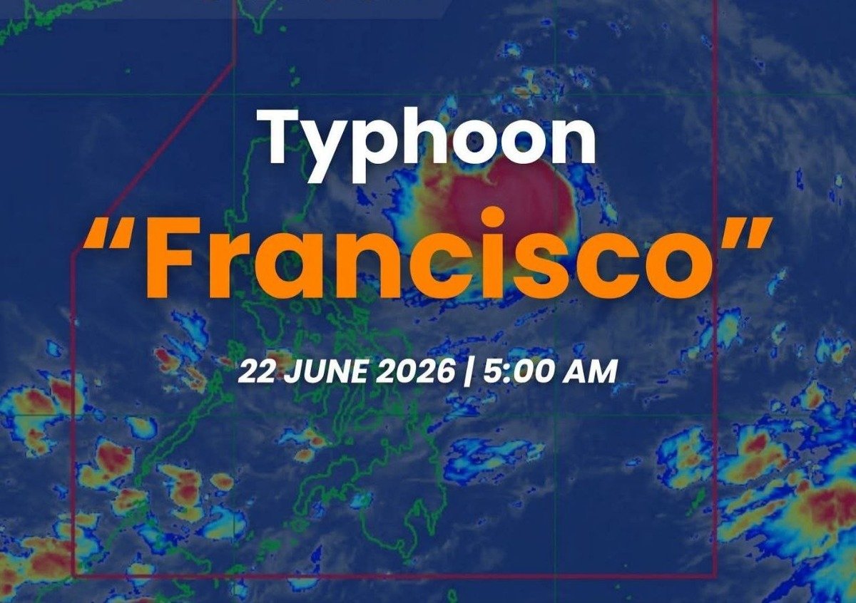
State weather agency DOST-PAGASA raised the first tropical cyclone wind signal over northern Philippine territories early Monday morning as Typhoon Francisco, known internationally as Mekkhala, continued to build strength while tracking west northwestward across the Philippine Sea at a speed of 30 kilometers per hour.
Storm Position as of Early Monday Morning
In its Tropical Cyclone Bulletin No. 6, released at 5:00 AM on June 22, 2026, DOST-PAGASA placed the center of Typhoon Francisco at approximately 715 kilometers east of Tuguegarao City in Cagayan, at coordinates 17.3°N, 128.5°E, as recorded at 4:00 AM the same day. The bulletin was set to remain valid until the next scheduled update at 11:00 AM on June 22.
Wind Strength and Structural Characteristics
According to DOST-PAGASA, Typhoon Francisco was carrying maximum sustained winds of 140 kilometers per hour near its center, with wind gusts climbing as high as 170 km/h. The storm’s central pressure was recorded at 965 hectopascals.
Tropical cyclone-force winds were extending outward up to 420 kilometers from the storm’s center, considerably widening the area at risk across the northern and eastern stretches of the Philippine Sea.
DOST-PAGASA projected that Francisco would continue to intensify over the next several hours, with peak intensity expected to be reached by Tuesday, June 23, 2026. The agency said a gradual weakening trend would follow as the typhoon slows down and begins to recurve.
TCWS No. 1 Raised Over Batanes and Northeastern Cagayan
As detailed in Bulletin No. 6, Tropical Cyclone Wind Signal No. 1 was hoisted over the following areas in Luzon: the entire province of Batanes, the municipalities of Gonzaga and Santa Ana in the northeastern portion of Cagayan, and portions of the Babuyan Islands — specifically Babuyan Island, Didicas Island, and Camiguin Island.
DOST-PAGASA explained that TCWS No. 1 means that strong winds ranging from 39 to 61 km/h — or Beaufort Scale 6 to 7 — are anticipated within a 36-hour warning lead time. The agency characterized the expected impact as presenting a “minimal to minor threat to life and property,” but noted that wind speeds could be locally higher in coastal zones and elevated or mountainous terrain exposed to the prevailing wind direction.
Habagat to Push Strong Winds Across Much of the Country
Beyond the direct effects of the typhoon, DOST-PAGASA warned that the Southwest Monsoon — known locally as the habagat — would generate strong to gale-force gusts across a much wider portion of the Philippines over the following days.
On Monday, June 22, those monsoon-driven winds were forecast to affect La Union, Pangasinan, CALABARZON, Romblon, Masbate, most of the Visayas, Zamboanga Peninsula, Misamis Occidental, Lanao del Norte, Camiguin, Surigao del Norte, Dinagat Islands, Davao Occidental, and Davao Oriental — with the strongest gusts expected in coastal and elevated areas.
By Tuesday, June 23, the monsoon’s reach was expected to broaden to cover most of Luzon, the Visayas, Zamboanga Peninsula, Northern Mindanao, Surigao del Norte, Dinagat Islands, Davao Occidental, and Davao Oriental. DOST-PAGASA forecast that this pattern would persist into Wednesday, June 24, continuing to affect most of Luzon, the Visayas, Dinagat Islands, Davao Occidental, and Davao Oriental.
Dangerous Sea Conditions Off Northern Luzon’s Coasts
DOST-PAGASA’s 24-hour sea condition forecast, as of June 22, 2026, warned of rough to moderate waters along the northern and eastern coasts of Luzon, posing hazards for maritime travel in those corridors.
Wave heights of up to 3.5 meters were forecast along the eastern seaboards of the Babuyan Islands and mainland Cagayan, while waves reaching up to 3.0 meters were expected off the eastern coasts of Batanes and Isabela.
DOST-PAGASA issued an explicit advisory for mariners: “Mariners of small seacrafts, including all types of motorbancas, are advised not to venture out to sea under these conditions, especially if inexperienced or operating ill-equipped vessels.”
Moderate sea conditions, with wave heights up to 2.5 meters, were forecast for the remaining seaboards of mainland Cagayan, Babuyan Islands, and Batanes; the coast of Aurora; the northern and eastern seaboards of Polillo Islands and Catanduanes; the northern seaboards of Camarines Norte and Camarines Sur; and the eastern seaboard of Davao Oriental.
Waves of up to 2.0 meters were expected along the northern seaboard of Ilocos Norte, the northeastern seaboard of mainland Quezon, the northern and eastern seaboards of Northern Samar, and the eastern seaboards of Albay, Sorsogon, Eastern Samar, Dinagat Islands, Surigao del Sur, and the southern seaboard of Davao Oriental. Operators of small watercraft were urged by DOST-PAGASA to exercise caution and avoid unnecessary sea travel under these conditions.
Forecast Track and Possibility of Closer Pass Over Northern Luzon
DOST-PAGASA’s track outlook indicated that Typhoon Francisco was expected to remain over the Philippine Sea throughout the forecast period, continuing its west-northwestward movement through Tuesday, June 23, before decelerating and eventually curving away.
The weather bureau projected that Francisco would exit the Philippine Area of Responsibility by Friday, June 26, 2026.
Notably, DOST-PAGASA included a critical caveat in Bulletin No. 6, stating that “a closer approach to Extreme Northern Luzon is not ruled out should there be a westward shift in the forecast track.” The agency acknowledged that the storm’s path could still shift within the limits of the forecast confidence cone and reminded the public that heavy rain and destructive winds could still be experienced in areas lying outside that cone.
Precautionary Measures Urged for Communities in Affected Zones
DOST-PAGASA called on local government units and their respective Disaster Risk Reduction and Management (DRRM) offices to put precautionary measures in place to protect lives and property in areas that may be affected by the typhoon and the enhanced monsoon.
In its bulletin, DOST-PAGASA stated: “Persons living in areas identified to be highly or very highly susceptible to these hazards are advised to follow evacuation and other instructions from local officials.” The agency also directed the public toward Weather Advisory No. 1, simultaneously released at 5:00 AM on June 22, for information on the heavy rainfall outlook linked to Francisco.
DOST-PAGASA further encouraged communities to monitor advisories from their respective local PAGASA Regional Services Division for area-specific weather updates, including thunderstorm and rainfall warnings, and to rely only on official government channels for weather information to prevent the spread of misinformation.
Next Weather Bulletin at 11:00 AM, June 22
The next Tropical Cyclone Bulletin covering Typhoon Francisco (Mekkhala) was scheduled by DOST-PAGASA for release at 11:00 AM on Monday, June 22, 2026, with subsequent bulletins to follow at regular intervals as the storm continues to develop. The public was reminded to source weather updates exclusively through official DOST-PAGASA platforms and to refrain from sharing unverified information that could trigger unnecessary alarm.
All data in this report is drawn from DOST-PAGASA Tropical Cyclone Bulletin No. 6, issued at 5:00 AM, June 22, 2026, tagged under #FranciscoPH.
Source: DOST-PAGASA / wire reports