The Philippine weather bureau has issued warnings for unstable atmospheric conditions that will bring thunderstorms and potential flooding risks to all regions of the country today, as a high pressure ridge creates volatile weather patterns across the archipelago.
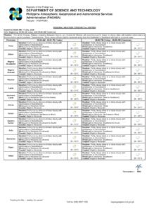
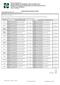
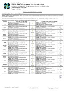
The Philippine Atmospheric, Geophysical and Astronomical Services Administration (PAGASA) released its comprehensive weather outlook at 4:00 AM this April 8, 2026, indicating that a ridge of high pressure area positioned over Northern and Central Luzon will generate partly cloudy to cloudy skies accompanied by isolated rainshowers and thunderstorms from the northernmost provinces to the southern islands.
Widespread Weather Pattern Affects All Island Groups
According to PAGASA’s meteorological analysis, the atmospheric disturbance will create uniform weather conditions across Luzon, Visayas, and Mindanao, with no region escaping the potential for severe weather development during afternoon and evening periods.
The weather service emphasizes that “Metro Manila and the rest of the country” will encounter comparable atmospheric conditions today, with localized weather systems likely to intensify into more dangerous conditions as daily temperature peaks are reached.
This comprehensive weather pattern spanning all three major island clusters demonstrates the extensive reach of the current atmospheric disturbance affecting the entire Philippine archipelago.
Temperature and Atmospheric Data
PAGASA’s Science Garden weather station in Quezon City recorded significant temperature variations yesterday, with the mercury climbing to 35.4°C at 5:00 PM and dropping to a cool 24.1°C at 5:00 AM. Humidity levels fluctuated dramatically between a peak of 83% during early morning hours and a low of 25% at 4:00 PM.
These temperature and moisture variations create ideal conditions for atmospheric instability, contributing to the thunderstorm development potential forecasted for today across the Philippines.
Regional Weather Analysis
Luzon Island Conditions
Despite the high pressure ridge’s presence over Northern and Central Luzon, these regions will not be immune to thunderstorm activity. The entire Luzon landmass will experience partly cloudy to cloudy conditions with scattered precipitation possibilities.
The National Capital Region faces variable sky conditions with sudden rainfall and thunderstorm potential, especially during traditional afternoon storm hours. Metro Manila’s forecast aligns with nationwide patterns, with no distinctive weather variations anticipated.
Southern Luzon areas will encounter identical meteorological conditions, featuring overcast periods and isolated shower development that may strengthen into significant thunderstorm activity during peak solar heating periods.
Central Philippines Weather Pattern
Visayas provinces will experience weather conditions matching those across the broader Philippines, with predominantly cloudy skies and thunderstorm potential. Island communities throughout the central archipelago should anticipate possible storm systems delivering short but intensive rainfall episodes.
Maritime conditions around Visayas waters will remain within slight to moderate parameters, allowing normal small vessel operations while requiring continuous weather monitoring throughout the day.
Southern Philippines Outlook
Mindanao will face similar atmospheric conditions affecting the entire country, with cloudy skies and isolated thunderstorm possibilities extending from northern provinces to the island’s southernmost regions.
The consistent weather pattern spanning such extensive Philippine territory reflects the broad atmospheric influence currently dominating the nation’s climate systems.
Marine and Wind Conditions
Wind patterns will vary moderately across regions, with Northern and Central Luzon experiencing east to southeast airflow while remaining Philippine areas encounter easterly to northeasterly wind directions at light to moderate speeds.
Sea conditions will remain generally favorable for maritime operations, with Northern and Central Luzon coastal zones experiencing light to moderate wave action, while other coastal areas maintain slight to moderate water conditions suitable for most marine activities.
Critical Safety Warnings
PAGASA issues stern warnings regarding “possible flash floods or landslides during severe thunderstorms,” highlighting significant hazard potential accompanying today’s weather systems.
Communities in flood-susceptible areas, including metropolitan regions with inadequate drainage infrastructure and low-elevation areas adjacent to waterways, must maintain heightened awareness throughout the day. Flash flooding can develop with minimal advance warning during intensive storm activity.
Mountainous and elevated terrain communities face additional landslide risks, particularly in locations with unstable soil composition or previous geological vulnerabilities. Intense thunderstorm precipitation can rapidly oversaturate ground conditions and trigger dangerous slope failures.
Vehicle operators should exercise enhanced caution during storm periods, as heavy precipitation reduces visibility significantly and creates treacherous driving surfaces. Metropolitan areas remain especially vulnerable to rapid street flooding and underpass inundation.
Outdoor activities require comprehensive contingency planning for abrupt weather deterioration. Personnel working in exposed environments should identify immediate shelter options and continuously observe atmospheric conditions for approaching storm indicators.
Forecast Duration and Updates
Current weather predictions remain effective until 4:00 AM tomorrow, April 9, 2026. PAGASA maintains continuous atmospheric monitoring to provide updated forecasts as conditions change and additional observational data becomes available from monitoring networks nationwide.
The meteorological service continues 24-hour weather surveillance to deliver prompt updates and emergency notifications as required. Given severe thunderstorm potential, supplementary advisories may be released if atmospheric conditions necessitate enhanced regional warnings.
Citizens should stay informed through official weather communications throughout today, as thunderstorm formation can be highly localized and rapidly evolving. Morning calm conditions can quickly deteriorate as afternoon atmospheric heating reaches maximum intensity.
Access current PAGASA information at pagasa.dost.gov.ph for latest meteorological updates and any additional alerts or advisories issued as weather systems develop.