Dumaguete City, Negros Oriental — Wednesday, July 15, 2026 — Skies over the Visayas will be unsettled on Wednesday, with the Philippine Atmospheric, Geophysical and Astronomical Services Administration (PAGASA) forecasting a mix of sunshine, rainshowers, and possible thunderstorms throughout the day. The agency’s Visayas Regional Forecast, released at 5:00 AM this morning, signals that conditions can shift quickly — and that residents, commuters, fisherfolk, and travelers should plan accordingly.
The forecast covers a wide swath of the central Philippines, including Negros Oriental, Siquijor, Cebu, and the rest of the Visayas group. While no major weather disturbance is driving today’s conditions, PAGASA’s bulletin makes clear that even routine wet-season thunderstorms carry genuine risks for those on the road, at sea, or working outdoors.
Today’s Forecast at a Glance
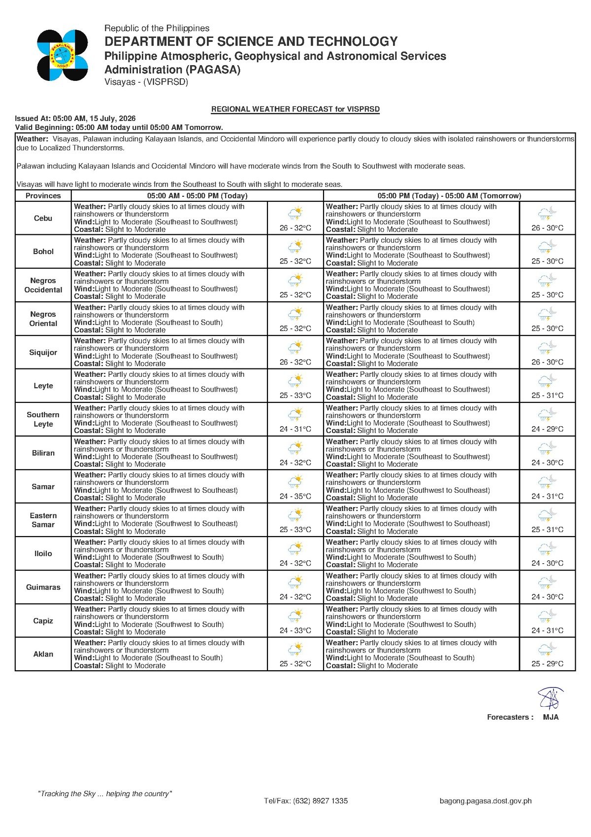
According to PAGASA’s 5:00 AM bulletin for the Visayas, skies will be partly cloudy to at times overcast, with rainshowers or thunderstorms expected to develop during the day. Temperatures across the region will range between a low of 26°C and a high of 32°C. Winds will blow from the southeast to southwest at light to moderate speeds, while coastal waters are described as slight to moderate.
PAGASA noted that the showers are not expected to be continuous or sustained throughout the day. Instead, the pattern is one of intermittent rainfall — bursts of rain, some accompanied by thunder and lightning, interspersed with partly sunny intervals. Thunderstorm activity typically peaks during the afternoon and early evening in the Visayas during the wet season, as daytime heating drives the development of convective clouds.
No Named Weather System Behind Today’s Rain
PAGASA’s bulletin does not identify a specific weather disturbance — such as a tropical cyclone, low-pressure area, or monsoon surge — as the primary cause of today’s conditions. The agency describes a pattern consistent with normal wet-season convective activity: moisture-laden air, daytime heating, and atmospheric instability combining to produce scattered showers and occasional thunderstorms.
No tropical cyclone wind signals, gale warnings, or formal rainfall advisories have been issued for the Visayas under today’s bulletin, PAGASA confirmed. That context is important: today’s rain is not the organized, large-scale kind associated with a tropical storm or a strong monsoon surge. Nevertheless, PAGASA’s forecast is a reminder that even garden-variety thunderstorms can produce bursts of intense, localized rainfall, sudden gusts of wind, and dangerous lightning strikes. The absence of a formal warning does not mean the risk is absent.
Coverage Across Negros Oriental and the Visayas
PAGASA’s regional forecast applies across all of the Visayas, encompassing the key population centers of Negros Oriental. Dumaguete City, the provincial capital, falls squarely within the area where partly cloudy skies and shower-prone conditions are expected. The same forecast applies to Bayawan City and Bais City in the south, the inland city of Guihulngan, and the island province of Siquijor across the Tañon Strait.
Across the broader Visayas — including Cebu and other central Philippine islands — PAGASA describes mirrored conditions: intermittent rainshowers or thunderstorms, light to moderate southeast-to-southwest winds, and slight to moderate coastal seas.
The agency’s extended weather outlook, issued the previous morning at 9:00 AM on July 14, reinforces the picture for Wednesday. That outlook had projected temperatures of 26°C to 32°C for today, with winds shifting to a southwest-to-south direction. The alignment between the extended outlook and the current bulletin suggests the unsettled pattern is expected to persist through the middle of the week, according to PAGASA.
By the Numbers
- 26°C — forecast low temperature for the Visayas on July 15
- 32°C — forecast high temperature for the Visayas on July 15
- 27°C to 33°C — temperature range projected for Tuesday, July 14, in PAGASA’s extended outlook
- 0.5 to 1.25 meters — wave heights classified as “slight seas” by PAGASA
- 1.25 to 2.5 meters — wave heights classified as “moderate seas” by PAGASA
- 5:00 AM — time of PAGASA’s Visayas Regional Forecast bulletin issuance
- 9:00 AM, July 14 — time of PAGASA’s prior extended weather outlook
Understanding Coastal Conditions: What PAGASA’s “Slight to Moderate” Means
PAGASA classifies today’s coastal waters across the Visayas as slight to moderate. In practical terms, slight seas correspond to wave heights of roughly 0.5 to 1.25 meters — generally navigable for most ferry types and outrigger craft under typical conditions. Moderate seas, on the other hand, involve wave heights of approximately 1.25 to 2.5 meters, which are manageable for larger inter-island vessels such as RO-RO ferries and fastcraft, but can be hazardous for small wooden fishing bancas and uncovered outrigger boats.
The slight to moderate classification means conditions may oscillate between the two ranges throughout the day, particularly if a passing thunderstorm squall temporarily intensifies wind speeds and sea chop. PAGASA has not issued a gale warning for Visayas waters in today’s bulletin, meaning no formal advisory restricts vessel movement at this time. However, the agency’s forecast underscores that the combination of moderate seas and possible thunderstorm squalls demands vigilance from anyone operating on the water.
Guidance for Different Groups
Commuters and Road Travelers
Those traveling by road — whether between Dumaguete and Bais, along the coastal highway toward Bayawan, or through the mountain routes near Guihulngan — should carry rain gear and build extra time into their journeys. PAGASA’s thunderstorm forecast means road visibility can drop sharply during rain bursts, and low-lying sections of road are vulnerable to flash flooding immediately after heavy showers. Mountain passes and coastal highways can become slippery when wet.
Ferry Passengers on Dumaguete Routes
Passengers taking fastcraft or ferry services from Dumaguete — including routes to Siquijor and Cebu — are advised to verify departure schedules directly with their operators before heading to the port. While PAGASA has not issued a gale warning, slight to moderate seas combined with the possibility of thunderstorm squalls may prompt precautionary delays for smaller or faster vessels. Operators such as OceanJet and other fastcraft services running out of Dumaguete Port should be contacted ahead of departure to confirm trip status.
Fisherfolk and Small Boat Operators
Small-boat fishermen from coastal towns across Negros Oriental face the most direct exposure to today’s sea conditions. PAGASA’s forecast of slight to moderate coastal waters, combined with the threat of sudden thunderstorm squalls, creates a situation where conditions on the water can deteriorate rapidly and with little advance notice. Fisherfolk venturing out are advised to stay close to shore, monitor the sky for developing storm clouds, and be prepared to return to port quickly if conditions worsen. Operators of very small bancas without outriggers or protective covers should carefully weigh whether it is safe to go out at all.
Farmers and Outdoor Workers
Inland agricultural areas, including farming communities around Guihulngan, La Libertad, and Canlaon, can expect periodic rain relief from the heat, but thunderstorms may interrupt outdoor fieldwork during the afternoon. Workers applying sprays or fertilizer are advised to take advantage of dry morning windows before afternoon convective activity intensifies. PAGASA’s forecast of possible lightning during thunderstorms is a serious safety consideration: those caught in the field during a storm should seek shelter immediately under a solid roof rather than under trees.
Schools and Afternoon Activities
Parents and school officials should note that peak thunderstorm hours in the afternoon may coincide with school dismissal times. Rain gear for students is advisable, and outdoor school events scheduled for the afternoon should have contingency arrangements in case of developing thunderstorms, consistent with PAGASA’s forecast pattern for the Visayas today.
Why This Matters
PAGASA’s July 15 Visayas forecast highlights the recurring challenge of wet-season weather management across the central Philippines: even without a named tropical cyclone or formal weather warning, intermittent thunderstorms pose real risks to commuters, fisherfolk, ferry passengers, and outdoor workers. The slight to moderate coastal sea classification, combined with the possibility of sudden thunderstorm squalls, means conditions on Visayas waters could shift rapidly during the day — a direct safety concern for small boat operators across the region. The consistency between PAGASA’s extended outlook and the current bulletin also suggests that residents and economic sectors across the Visayas should expect this unsettled pattern to continue through the middle of the week, requiring ongoing preparedness rather than a single-day adjustment.
Source: Breaking News Negros Oriental (breakingnewsnegrosoriental.com), citing PAGASA Visayas Regional Forecast issued July 15, 2026.