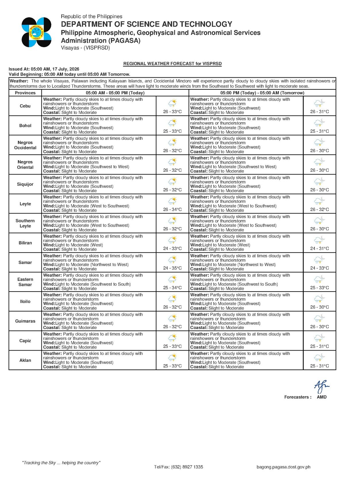
The Philippine Atmospheric, Geophysical and Astronomical Services Administration (PAGASA) has placed the entire Visayas region — including Negros Oriental, Siquijor, and surrounding areas — under a forecast of partly cloudy skies with rainshowers and thunderstorms for Friday, July 17, 2026. The agency released the regional weather bulletin at 5:00 AM, signaling another wet day shaped by the ongoing southwest monsoon season.
No typhoon or severe tropical storm is currently threatening the region, but PAGASA warns that the wet, unsettled conditions are sufficient to disrupt daily routines across the island group. Coastal communities, commuters, outdoor workers, and farming households are among those expected to feel the effects of today’s weather pattern throughout the day and into the evening.
The Force Behind Today’s Weather
According to PAGASA, the dominant atmospheric driver today is the southwest monsoon — known locally as habagat — which is pushing warm, moisture-laden winds from the southwest across the Philippine archipelago at light to moderate speeds. This seasonal wind system typically arrives mid-year and is a normal feature of the Philippine wet season.
When the moist southwest winds encounter landmasses or interact with other atmospheric systems, PAGASA explains, they generate the scattered rainshowers and thunderstorm clusters being forecast today. A key characteristic of habagat-driven rainfall, the agency notes, is its localized and sometimes unpredictable nature — heavy downpours may occur in one barangay while an adjacent town experiences only overcast skies.
PAGASA’s extended outlook, issued at 9:00 AM on July 16, 2026, indicates that this southwest-to-south wind pattern will persist through Saturday, July 18, and Sunday, July 19, with little change in wind direction or intensity expected over the next 48 hours.
Weather Conditions for Negros Oriental and the Visayas — July 17
For Friday, PAGASA’s forecast for the Visayas region, which covers Negros Oriental and Siquijor, includes the following specific parameters:
- Sky condition: Partly cloudy, at times cloudy
- Expected precipitation: Rainshowers or thunderstorms
- Temperature range: 26°C (low) to 33°C (high)
- Wind direction: Southwest
- Wind speed: Light to moderate
- Coastal sea conditions: Slight to moderate
In Dumaguete City, the provincial capital of Negros Oriental, residents can expect warm, humid air throughout the day with intermittent cloud cover and the possibility of sudden rain at any hour. Coastal cities including Bayawan, Bais, and Tanjay — along the western and southern shores of the island — face the same forecast conditions, as do highland municipalities farther inland such as Guihulngan and La Libertad.
On Siquijor Island, PAGASA projects similar rainshower activity driven by the same southwest winds. Passengers planning to travel by ferry between Dumaguete and Siquijor, or to and from other nearby islands, are advised to check with their respective operators — such as OceanJet and other inter-island lines — regarding the status of scheduled sailings before heading to the port.
Understanding the Coastal Warning
PAGASA’s classification of sea conditions as “slight to moderate” carries practical implications for fishing communities and maritime commuters. Slight seas are generally defined as wave heights ranging from 0.5 to 1.25 meters — manageable for larger vessels but potentially uncomfortable for small, open watercraft. Moderate seas, with wave heights between 1.25 and 2.5 meters, represent a genuine hazard for the bancas and outrigger boats that fisherfolk in Negros Oriental and Siquijor commonly use.
The agency notes that conditions rated “slight to moderate” can shift rapidly within a single hour, especially when a thunderstorm cell passes directly overhead. Winds intensify and seas respond quickly under such events, often without advance warning at the local level.
PAGASA advises small boat operators and fisherfolk to consult the latest marine weather bulletin before departing and to remain within safe distances from shore. Anyone relying on inter-island ferry services should verify sailing schedules directly with operators, as delays or cancellations may be issued if conditions worsen during the day.
Practical Guidance by Sector
Commuters and Motorists
Wet road surfaces can be expected at various points throughout the day in Dumaguete, Valencia, Santa Catalina, and other municipalities across Negros Oriental. Thunderstorms may reduce visibility, particularly on mountain roads and routes leading to interior barangays. Motorists and motorcycle riders are advised to reduce speed on curves and build extra travel time into their schedules. Pedestrians should carry rain gear, as habagat-season thunderstorms tend to develop quickly with little forewarning.
Fishing Communities and Boat Operators
Given that PAGASA has rated coastal conditions as slight to moderate and thunderstorms are possible throughout the day, small-boat fishing trips to open waters carry elevated risk. Fisherfolk in Bayawan, Bais, Bindoy, Amlan, and along the Siquijor coastline are encouraged to stay close to shore and return to port at the first sign of darkening skies or approaching thunder. Lightning over open water is a direct and serious hazard, the agency emphasizes.
Farmers and Agricultural Workers
For farmers working sugarcane fields in the lowlands and vegetable plots in the highlands of Negros Oriental — including areas near Guihulngan and the Cuernos de Negros foothills — today’s showers may provide useful soil moisture. However, sudden heavy rainfall associated with thunderstorms can cause localized flooding in low-lying fields. PAGASA recommends securing loose materials before leaving farm areas unattended and monitoring irrigation channels and drainage when heavy rain sets in.
Students, Schools, and Parents
As of the 5:00 AM PAGASA bulletin, no typhoon signal or severe weather warning has been raised for the region, and no class suspension has been declared based on the current forecast. Nonetheless, parents are urged to send children to school equipped with rain gear. Schools located in flood-prone low-lying zones are encouraged to closely monitor weather conditions during the afternoon dismissal period, when thunderstorm activity often peaks. Local government units retain the authority to call class suspensions based on actual on-the-ground conditions, according to standard protocols.
Outdoor Events and Construction Workers
Those engaged in outdoor construction, agriculture, or other open-air industries should plan tasks around the likelihood of midday or afternoon thunderstorm activity. Event organizers staging outdoor activities in any part of Negros Oriental today are advised to prepare contingency plans for sudden rain. Lightning safety protocols — specifically, seeking shelter inside a sturdy structure at the first sound of thunder — remain in effect throughout the forecast period.
Three-Day Outlook: Saturday and Sunday
PAGASA’s extended forecast, covering July 18 (Saturday) and July 19 (Sunday), projects largely similar conditions. Temperatures are expected to hold between 27°C and 33°C on both days, with winds remaining light to moderate from the southwest to south. Coastal sea conditions are projected to stay in the slight to moderate range, and scattered rainshowers with thunderstorms are likely to continue.
The persistence of the southwest monsoon signal over this three-day window, as indicated by PAGASA, suggests that residents and workers across Negros Oriental and the broader Visayas region should treat unsettled, rainy weather as the baseline condition for the coming days rather than an isolated event.
By the Numbers
- 26°C – 33°C: Temperature range forecast by PAGASA for the Visayas on July 17
- 27°C – 33°C: Projected temperature range for Saturday, July 18 and Sunday, July 19
- 0.5 – 1.25 meters: Typical wave height range for “slight” sea conditions
- 1.25 – 2.5 meters: Wave height range for “moderate” sea conditions
- 5:00 AM: Time of PAGASA’s July 17 regional forecast issuance
- 9:00 AM, July 16, 2026: Time and date of the extended three-day outlook issued by PAGASA
Why This Matters
The southwest monsoon’s sustained grip on the Visayas through at least July 19, as forecast by PAGASA, means that communities across Negros Oriental and Siquijor face multiple consecutive days of unpredictable, potentially hazardous rainfall rather than a single isolated weather event. The “slight to moderate” coastal advisory directly affects the livelihoods of fisherfolk who depend on daily sea access, while the thunderstorm risk creates safety concerns for commuters, farmers, students, and outdoor workers. Residents and local officials who treat this as a multi-day pattern — rather than a one-time inconvenience — will be better positioned to protect both safety and economic activity across the affected communities.
Source: Breaking News Negros Oriental (breakingnewsnegrosoriental.com)