DUMAGUETE CITY — A wet and unsettled Wednesday is in store for communities across Negros Oriental and the rest of the Visayas, as the Philippine Atmospheric, Geophysical and Astronomical Services Administration (PAGASA) warns of rainshowers and thunderstorms developing throughout June 3, 2026. The weather pattern is driven by the southwest monsoon, which has begun asserting itself across this part of the archipelago, and is expected to affect everything from daily commutes to inter-island ferry crossings, farm work, and open-water fishing.
PAGASA’s Morning Forecast for the Visayas
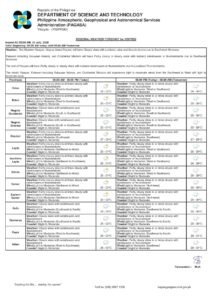
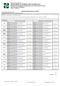
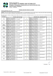
According to PAGASA’s Visayas regional forecast issued at 5:00 AM on Wednesday, June 3, 2026, skies will begin partly cloudy before shifting at times to heavy cloud cover as the day progresses. Rainshowers and the possibility of thunderstorms are expected to develop at various points, consistent with the kind of convective weather that the Visayas experiences once the southwest monsoon — known locally as Habagat — settles in.
PAGASA places the temperature range for the day between 27°C on the low end and 33°C on the high end. While these figures are warm, the cloud cover and intermittent rain will keep conditions from becoming oppressive. Winds are forecast to blow from the southwest to south at light to moderate speeds — not severe enough to trigger gale warnings, but sufficient to stir up choppiness on open water and inland sea channels.
The forecast covers the entirety of the Visayas, meaning provinces including Cebu, Bohol, Negros Occidental, Iloilo, and Leyte are all under the same general pattern. Negros Oriental, Siquijor, and neighboring islands are squarely within this zone.
What This Means for Dumaguete and the Province
For residents of Dumaguete City, the provincial capital of Negros Oriental, the day is likely to begin with a deceptive calm before afternoon and early evening hours bring the most active weather. Convective thunderstorms in the Visayas typically peak during those later hours of the day, PAGASA’s patterns consistently show, making the post-noon period the most probable window for heavier rain and lightning activity.
Those heading out for errands, work, or school are strongly advised to carry umbrellas or rain gear regardless of morning conditions. Tricycle and habal-habal riders — who form the backbone of local transportation across the province — should be particularly cautious when thunderstorms develop, as road surfaces in lower-lying barangays can become slippery and prone to flash flooding.
In the northern corridor of the province, communities around Guihulngan City can expect conditions that mirror those further south. Meanwhile, Bais City — a coastal hub known for dolphin-watching tourism — faces slight to moderate sea states that may allow tours to proceed, though operators there are urged by PAGASA to monitor conditions closely and make real-time decisions based on the latest updates.
Along the southern stretch of the province, Bayawan City and the coastal municipalities fronting the Tañon Strait will likewise experience intermittent rain. The strait, which separates Negros Oriental from Cebu, is known to develop rougher swells when southwest winds pick up, and small fishing vessels should exercise extra caution before venturing into open waters.
Inter-Island Travel and Ferry Services
PAGASA classifies coastal waters across the region today as slight to moderate — a rating that generally indicates waves are within manageable range for most commercial vessel types, but that does not guarantee smooth sailing when a thunderstorm moves through.
Passengers travelling on inter-island routes out of Dumaguete port — including fast craft and ferry services operated by carriers such as OceanJet and Montenegro Lines connecting to Siquijor, Cebu, and other Visayas destinations — are advised to confirm departure status with their respective operators before heading to the terminal, particularly for afternoon and evening sailings when weather volatility tends to be at its highest.
The short sea crossing from Dumaguete or Sibulan to Siquijor Island deserves special attention. Although brief, the passage can become choppy rapidly when a squall or thunderstorm passes through, and PAGASA notes that squalls — characterized by sudden, intense bursts of wind and rain — can develop with little advance warning during the monsoon season.
Guidance for Farmers and Fishing Communities
Agricultural workers in the interior municipalities of Negros Oriental — including those in Pamplona, Tayasan, La Libertad, and surrounding areas where sugarcane, rice, and vegetable cultivation are common — will find the onset of regular rainfall broadly beneficial for crops at this stage of the growing calendar. However, PAGASA cautions that thunderstorms pose genuine hazards for field workers.
The agency specifically advises agricultural workers to seek shelter away from open fields and tall trees whenever lightning or thunderstorm activity is observed. Harvested produce and farming equipment should be secured before heavy downpours arrive to prevent damage or loss. PAGASA also directs farmers to its dedicated agri-weather forecasting service, accessible through the agency’s official website at pagasa.dost.gov.ph, for more granular, location-specific guidance throughout the season.
Fisherfolk working along Negros Oriental’s eastern coastline and around the waters of Siquijor Island are similarly urged to take heed. PAGASA’s advisory makes clear that while the light to moderate wind classification does not represent a formal gale warning, the presence of thunderstorm potential means sudden squalls remain a real risk. Small bangka operators are encouraged to stay close to shore or hold off departure if storm clouds are visible on the horizon.
Extended Outlook Through Mid-Week
Looking beyond Wednesday, PAGASA’s extended forecast — issued at 9:00 AM on June 2, 2026 — indicates that the unsettled weather pattern will persist into the following days. For the latter part of the week, temperatures are projected to climb slightly higher, reaching up to 34°C, while nighttime lows are expected to hold at between 27°C and 28°C. Wind direction remains anchored from the south to southwest at light to moderate speeds, with coastal conditions staying at the slight to moderate classification.
This sustained outlook is in keeping with the Habagat season, which typically brings wetter and cloudier conditions to the Visayas from June through September. PAGASA signals that residents should view this week’s weather not as a one-off event but as the opening chapter of a prolonged wet season that will demand continued vigilance.
Schools, Events, and Outdoor Planning
Organizers of outdoor gatherings in Dumaguete and across Negros Oriental should factor rain contingencies into their planning for the remainder of the week. School administrators and parents are reminded that while today’s forecast does not carry the intensity typically required to trigger class suspensions, afternoon thunderstorms could complicate dismissal time for students — especially those who walk or commute by tricycle.
Local government units (LGUs) across the province are also encouraged to inspect drainage infrastructure and identify flood-prone low-lying areas in their jurisdictions now, before the wet season intensifies further. Preemptive action on drainage and waterway clearing can significantly reduce the impact of the heavier rain events that the southwest monsoon regularly produces in the months ahead.
Stay Updated Throughout the Day
Weather conditions across the Visayas can shift quickly, particularly once the monsoon is in full swing. PAGASA issues updated bulletins throughout the day, and residents of Negros Oriental — whether in Dumaguete, Bayawan, Bais, Guihulngan, Siquijor, or any of the province’s municipalities — are strongly encouraged to check official advisories regularly. The agency’s website at pagasa.dost.gov.ph remains the most authoritative source for real-time weather information and is updated multiple times daily.
As PAGASA’s 5:00 AM forecast summarizes: partly cloudy to at times cloudy skies with rainshowers or thunderstorms, temperatures from 27°C to 33°C, light to moderate southwest to south winds, and slight to moderate coastal conditions — a textbook Habagat day for this part of the Philippines.
Source: Breaking News Negros Oriental (breakingnewsnegrosoriental.com)