Combined Storm Systems Put Northern Philippines on Alert
Two weather systems working in tandem are making conditions dangerous across a large portion of the Philippines this Friday, June 5, 2026. Tropical Depression “Ester” and an energetic Southwest Monsoon — the seasonal wind pattern Filipinos call habagat — are pushing heavy rainfall, gusty winds, and rough seas onto Luzon, with the northernmost island group of Batanes bearing the most severe impact of the combined systems.
The Philippine Atmospheric, Geophysical and Astronomical Services Administration (PAGASA) released its 24-hour public weather forecast at 4:00 AM today, with the bulletin remaining valid through 4:00 AM on Saturday, June 6. According to PAGASA, while Batanes faces the harshest conditions, the reach of the habagat stretches well beyond the north, carrying risks of rain and thunderstorms to communities across Luzon and into isolated parts of the Visayas and Mindanao.
Position and Movement of Tropical Depression Ester
PAGASA reported that as of 3:00 AM this morning, Tropical Depression Ester’s center was located approximately 220 kilometers northwest of Itbayat, Batanes, at coordinates 21.9°N, 120.1°E. The weather disturbance is packing maximum sustained winds of 45 kilometers per hour close to its center, with gusts of up to 55 km/h. The system is moving in a northeastward direction at 20 km/h.
Beyond its own direct effects, PAGASA noted that Ester is simultaneously strengthening the Southwest Monsoon’s grip over Northern and Central Luzon, widening the zone of rain and wind hazards across the country’s northern half.
Hazard Breakdown by Area
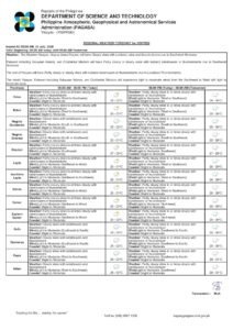
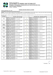
Batanes: Highest Alert
The Batanes island group — the Philippines’ northernmost province — is under the most serious weather threat of any area in the country today. PAGASA warns that the province will experience rains with gusty winds directly caused by Tropical Depression Ester, with moderate to heavy rainfall raising a clear risk of flash floods and landslides. The agency also flagged a minimal to minor threat to life and property from strong wind conditions in the area.
Local residents and government units in Batanes are being urged to exercise heightened caution, especially those who live near riverbanks, coastal low-lying areas, and hillsides or mountain slopes with known landslide susceptibility.
Ilocos Region, Abra, Benguet, and Zambales
The habagat is steering occasional rains that may at times intensify to heavy or intense levels over the Ilocos Region, Abra, Benguet, and Zambales, according to PAGASA. These areas face an elevated risk of flash floods and landslides as a result. Communities situated in the rugged terrain of Abra and Benguet are especially vulnerable because of the steep topography and the tendency of saturated soil to give way during prolonged or intense downpours.
Metro Manila, Remaining Luzon Provinces
Metro Manila should expect overcast skies with scattered rains and thunderstorms throughout the day, all driven by the active Southwest Monsoon. The rest of Cagayan Valley — excluding Batanes — as well as remaining provinces within the Cordillera Administrative Region, plus Bataan, Cavite, Batangas, and Occidental Mindoro, will see similar conditions.
PAGASA cautioned that moderate rainfall in these zones could periodically intensify, raising risks of flash floods particularly in flood-prone urban districts of Metro Manila and in the highland sub-regions of the Cordillera. Households in low-lying neighborhoods near waterways and drainage channels are advised to keep close watch on alerts issued by their respective local disaster risk reduction and management offices.
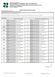
Visayas and Mindanao: Calmer but Not Without Risk
Areas not directly under the influence of Tropical Depression Ester or the organized monsoon bands — including most of the Visayas, Mindanao, and portions of Luzon not listed above — can expect partly cloudy to cloudy skies, with isolated rain showers or thunderstorms developing from localized convective activity.
Although the overall picture is considerably less threatening for these regions, PAGASA still cautioned that severe isolated thunderstorms remain capable of triggering localized flash floods and landslides. Those engaged in outdoor work or recreation, especially near mountainous terrain or exposed coastlines, should factor these risks into their plans for the day.
Winds and Sea Conditions
Over Northern and Central Luzon, PAGASA forecast moderate to strong winds blowing out of the southwest. Coastal waters in this zone will be moderate to rough, with wave heights running between 1.2 and 3.4 meters. The agency strongly advised small watercraft operators — including fishing vessels and inter-island boats plying shorter routes — to exercise extreme care or to refrain entirely from putting out to sea under these conditions.
Elsewhere in the country, winds will be light to moderate and also from the south to southwest. Coastal waters outside Northern and Central Luzon will remain slight to moderate, with wave heights ranging from 0.6 to 1.5 meters. PAGASA nonetheless reminded mariners that sudden squalls associated with isolated thunderstorms can rapidly alter sea conditions even in otherwise calmer waters.
Metro Manila Temperature and Humidity Data
Instrument readings from PAGASA’s weather station at Science Garden in Diliman, Quezon City recorded yesterday’s temperature range at a high of 31.8°C at noon and a low of 25.4°C at 6:00 AM. Relative humidity over the same 24-hour period ending at 8:00 PM yesterday fluctuated between a peak of 88 percent and a low of 61 percent.
The persistent cloud cover, intermittent rainfall, and elevated humidity are expected to combine to produce a muggy and oppressive feel throughout the day in Metro Manila and other densely populated urban centers. Residents are encouraged to drink plenty of fluids and choose light, breathable clothing to manage the heat and moisture.
Astronomical and Tidal Data for Metro Manila — June 5, 2026
Sunrise in Metro Manila is set for 5:26 AM, with sunset at 6:23 PM. The moon will rise at 10:22 PM and set at 9:14 AM, currently in a waxing gibbous phase at 77 percent illumination. Tidal information published by the National Mapping and Resource Information Authority (NAMRIA) indicates a high tide of 1.2 meters in Manila Bay at 12:24 PM today, followed by a low tide of -0.07 meters at 9:24 PM this evening.
Key Safety Precautions
With flash floods and landslides identified by PAGASA as the dominant hazards across several regions today, disaster preparedness authorities consistently recommend the following actions during active monsoon or tropical depression episodes:
Residents in flood-prone barangays should know the location of their nearest evacuation center and be prepared to leave on short notice once local officials issue the order to do so. Communities in landslide-prone upland areas — particularly across the Cordillera, Abra, and Batanes — should keep well away from slopes and hillsides during and immediately after heavy rainfall. Drivers must avoid flooded roads at all times, as shallow floodwaters may hide deep drops, debris, or powerful hidden currents. Fisherfolk and boat operators along the Northern and Central Luzon coastlines are strongly urged to stay ashore given the forecast of moderate to rough seas and wave heights of up to 3.4 meters, according to PAGASA.
PAGASA will continue tracking Tropical Depression Ester and monitoring the evolving behavior of the Southwest Monsoon throughout the day and into Saturday. Weather patterns may shift rapidly, and the public — most urgently those in Batanes and across Northern Luzon — is strongly encouraged to check for updated weather bulletins regularly through the official PAGASA website at pagasa.dost.gov.ph.
Originally reported by: wire reports