MANILA, June 6, 2026 — Wet and hazardous conditions gripped much of Luzon on Saturday as two weather systems — Tropical Depression “Ester” and a strengthened Southwest Monsoon, locally called the habagat — worked together to produce heavy rainfall, elevated flash flood risks, and dangerous coastal waters across the northern Philippines. The Philippine Atmospheric, Geophysical and Astronomical Services Administration (PAGASA) issued its advisory based on a 4:00 AM forecast covering the full 24-hour period through 4:00 AM on Sunday, June 7.
PAGASA warned that the dual influence of TD Ester and the active monsoon could trigger flash floods and landslides in multiple provinces, urging communities — particularly those situated in low-lying areas and along mountain slopes — to remain on alert throughout the day.
TD Ester’s Position and Behavior
According to PAGASA, the center of Tropical Depression Ester was situated approximately 350 kilometers north-northeast of Itbayat, Batanes as of 3:00 AM on Saturday, positioned at coordinates 23.8°N, 122.8°E. The system was packing maximum sustained winds of 45 km/h near its center, with gusts reaching up to 55 km/h, and was moving in an east-northeastward direction at 15 km/h — tracking away from Philippine territory rather than toward it.
Despite not threatening a direct landfall, PAGASA noted that TD Ester’s offshore presence is actively reinforcing the Southwest Monsoon currently affecting Northern and Central Luzon, amplifying rainfall and severe weather potential across the region.
Weather Conditions Across Luzon
Luzon is bearing the heaviest impact of the combined weather systems, with PAGASA outlining several zones of concern across the island group.
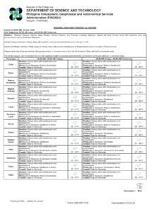
Ilocos Region, Abra, Benguet, Zambales, and Bataan
These areas can expect occasional rains throughout Saturday, driven mainly by the Southwest Monsoon. While rainfall will be intermittent, PAGASA cautioned that moderate to heavy downpours are possible at certain periods, raising the risk of flash floods and landslides — especially in the sloped and mountainous terrain of Abra and Benguet. Residents living near riverbanks, hillsides, and flood-prone communities should remain vigilant.
Metro Manila and Adjacent Provinces
The National Capital Region is in for a considerably wet Saturday. PAGASA’s forecast calls for cloudy skies with scattered rains and thunderstorms over Metro Manila, which can produce sudden, intense downpours capable of overwhelming drainage infrastructure and causing urban flooding. Outdoor workers and daily commuters are advised to prepare for disruptions, particularly in areas historically prone to road flooding.
Cagayan Valley and the Cordillera Administrative Region
Both Cagayan Valley and the Cordillera Administrative Region (CAR) share the same forecast of cloudy skies with scattered rains and thunderstorms. PAGASA flagged the risk of flash floods and landslides due to moderate to occasionally heavy rainfall. Upland communities in the Cordillera are considered especially vulnerable during sustained or intense rainfall events, and residents in these areas are encouraged to monitor local government advisories and be prepared to evacuate if ordered to do so.
Remaining Central Luzon Provinces, Rizal, Cavite, Batangas, and Occidental Mindoro
A similar forecast of cloudy skies with scattered rains and thunderstorms applies to these provinces. Flash flooding and landslides remain potential hazards, particularly near rivers, elevated terrain, and flood-susceptible zones. Coastal communities in Batangas and Occidental Mindoro should additionally keep a close watch on sea conditions given the rough coastal waters expected in the area.
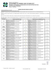
Visayas and Mindanao: Calmer but Not Clear
Weather conditions improve markedly across the southern regions, though PAGASA stressed that Saturday is not risk-free for the Visayas or Mindanao.
Across the rest of the country — including all three Visayas regions and the various administrative regions of Mindanao — PAGASA forecast partly cloudy to cloudy skies with isolated rain showers or thunderstorms. These episodes are expected to be driven by localized convective activity rather than an organized weather disturbance.
Even so, PAGASA pointed out that isolated thunderstorms retain the potential to generate localized flash floods or landslides when they pass over vulnerable terrain. Residents throughout the Eastern, Western, and Central Visayas regions, as well as communities across Mindanao — from the Davao region to the Bangsamoro Autonomous Region in Muslim Mindanao (BARMM) — should remain aware of the possibility of sudden, localized heavy rainfall even during otherwise partly sunny periods.
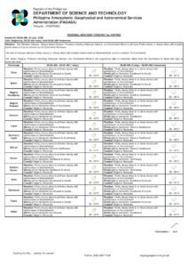
Sea Conditions and Advisories for Mariners
PAGASA also issued warnings regarding hazardous wave conditions off the coasts of Luzon, which pose a direct danger to those at sea.
Along the coastlines of Northern Luzon and the western portion of Central Luzon, winds will blow moderately to strongly from the southwest, producing coastal waters that are moderate to rough, with wave heights forecast between 1.2 and 3.1 meters. These conditions are considered dangerous for small fishing boats and bancas. PAGASA strongly advised fisherfolk and mariners operating in these waters to take extreme precautions or remain ashore wherever possible.
For coastal areas in the rest of the archipelago, winds will be light to moderate from the south to southwest direction, with seas classified as slight to moderate and wave heights ranging from 0.6 to 1.8 meters. Although less severe, smaller watercraft should still exercise care — particularly during afternoon and early evening hours when thunderstorm activity typically peaks.
Temperature and Humidity Readings
PAGASA’s monitoring station at Science Garden in Diliman, Quezon City recorded a maximum temperature of 28.8°C — logged at 11:00 AM the previous day — and a minimum of 26.2°C recorded at 8:00 PM, based on the 24-hour observation period ending at 8:00 PM on Friday. Relative humidity levels ranged from a high of 92% down to a low of 78%, reflecting the moisture-saturated atmospheric conditions characteristic of the monsoon season.
The elevated humidity means the air will feel warm and oppressive even during rain-free intervals. PAGASA and health authorities consistently advise vulnerable individuals — including the elderly, young children, and those with existing respiratory or cardiovascular conditions — to stay well-hydrated and minimize prolonged exposure to the outdoors during the hottest and most humid portions of the day.
Manila Bay Tidal Forecast
For coastal communities around Manila Bay, PAGASA cited tidal predictions supplied by the National Mapping and Resource Information Authority (NAMRIA), projecting a high tide of 1.16 meters at 1:08 PM and a low tide of -0.02 meters at 10:04 PM on Saturday. With significant rainfall expected throughout the day, residents along the Manila Bay shoreline and in low-lying coastal barangays should factor in the risk of coastal inundation during the high-tide window.
Astronomical Data for Metro Manila
According to PAGASA, sunrise in Metro Manila on Saturday falls at 5:26 AM with sunset at 6:24 PM. The moon is scheduled to rise at 11:01 PM and set at 10:05 AM, presenting a waxing gibbous phase at 69% illumination.
Safety Precautions Urged
PAGASA and local disaster risk reduction and management offices consistently remind the public to observe precautionary measures whenever active monsoon conditions and tropical disturbances are present. Households in flood-prone zones and communities near mountain slopes are urged to prepare go-bags, identify evacuation routes, and monitor official advisories from local government units and the national weather agency. The public is also reminded not to cross flooded roads and to avoid rivers, creeks, and coastal areas during periods of heavy rainfall and strong waves.
Residents are encouraged to follow PAGASA’s official social media channels and local government announcements for real-time updates as weather conditions evolve throughout the day.
Originally reported by: PAGASA / wire reports