Shallow Offshore Quake Rattles Parts of Antique Province
A tectonic earthquake measuring Magnitude 4.5 struck waters off the coast of Antique province on the afternoon of Saturday, June 6, 2026, with seismic monitoring authorities confirming afterward that no structural damage and no aftershocks are expected from the event. The tremor was felt at low intensities in select municipalities within the province.
Time, Location, and Depth of the Earthquake
According to the Philippine Institute of Volcanology and Seismology (PHIVOLCS-DOST), the earthquake occurred at exactly 5:07 in the afternoon, Philippine Standard Time (PHT), on June 6, 2026. The agency classified it as a Magnitude 4.5 (Mw) tectonic earthquake — meaning the seismic activity was caused by natural movement and stress along tectonic structures beneath the earth’s surface.
PHIVOLCS-DOST further noted that the quake originated at a very shallow depth of only 3 kilometers below the surface. Shallow earthquakes of this kind tend to be felt more readily at the surface compared to deeper events, even when their magnitude is relatively modest.
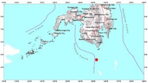
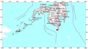
The epicenter was pinpointed at geographic coordinates 10.19°N, 121.57°E, which places the origin point roughly 48 kilometers south-southwest of Anini-y, Antique — well offshore in the waters lying to the west of the Antique coastline. PHIVOLCS-DOST released an epicentral map as an attachment to its official bulletin for this event.
Where and How Strongly It Was Felt
The tremor was registered at measurable intensities in Antique province, with both reported and instrumentally detected readings available from the agency. Intensities were measured using the PHIVOLCS Earthquake Intensity Scale (PEIS), the official standard used in the Philippines for describing the strength of ground shaking experienced at various locations.
Reported Shaking Intensities
PHIVOLCS-DOST reported that Intensity II shaking was felt in two Antique localities: Anini-y and San Jose de Buenavista. Under the PEIS, an Intensity II reading is described as faint — typically noticed only by a small number of individuals, particularly those who are at rest or in very quiet surroundings. The sensation has been likened to the slight vibration caused by a vehicle passing nearby.
Instrumentally Recorded Intensities
Seismic instruments operated by PHIVOLCS-DOST captured a slightly broader picture of ground motion across the province. The agency’s data showed the following instrumental readings:
- Intensity II — San Jose de Buenavista, Antique
- Intensity I — Anini-y, Culasi, and Valderrama, Antique
Intensity I on the PEIS is considered scarcely perceptible — at this level, shaking is generally too faint to be felt by people and is detectable primarily through sensitive seismic instruments rather than human sensation.
No Damage, No Aftershocks Expected
In its official assessment, PHIVOLCS-DOST stated that the June 6 earthquake is not expected to produce any damage to structures or infrastructure. The agency also assessed that no aftershocks are anticipated to follow the main event.
The combination of the quake’s offshore epicenter, its moderate magnitude, and the relatively low intensities felt in populated areas all point to a seismic event that, while perceptible to some residents, posed no significant hazard. PHIVOLCS-DOST indicated that this bulletin would serve as the sole official notice for the earthquake unless new or additional information warrants a follow-up advisory.
Bulletin Details and How to Stay Informed
The official earthquake bulletin for this event was released by PHIVOLCS-DOST at 10:58 PM PHT on June 6, 2026. It was prepared by the agency’s duty seismologists as part of its standard earthquake monitoring and public information protocols.
PHIVOLCS-DOST routinely issues such bulletins for earthquakes felt at measurable intensities anywhere in the Philippines. The agency advises the public to rely on its official communications for accurate and timely seismic information, rather than unverified sources circulating on social media platforms.
Members of the public who wish to monitor earthquake activity and receive the latest updates are encouraged by PHIVOLCS-DOST to visit the agency’s official website at phivolcs.dost.gov.ph, where bulletins, intensity maps, and seismic data are regularly posted and updated.
Background: Antique and Seismic Activity
The western coast of Panay Island, where Antique province is situated, lies within a seismically active region of the Philippines. The country sits along the Pacific Ring of Fire, a belt of tectonic plate boundaries responsible for a large proportion of the world’s earthquakes and volcanic eruptions. Low- to moderate-magnitude tremors are not uncommon in this part of the Visayas, and PHIVOLCS-DOST continuously monitors seismic networks across the archipelago to provide timely public advisories.
Residents in earthquake-prone areas are generally advised by disaster risk authorities to remain calm during minor tremors, check their immediate surroundings for hazards following any felt earthquake, and follow guidance from official agencies such as PHIVOLCS-DOST and local disaster risk reduction offices when assessing whether further action is needed.
Originally reported by: PHIVOLCS-DOST official earthquake bulletin / wire reports