Just over 24 hours after a destructive magnitude 7.8 earthquake shook offshore Sarangani, another significant tremor rattled the same stretch of southern Philippine waters on the morning of Tuesday, June 9, 2026. The Philippine Institute of Volcanology and Seismology under the Department of Science and Technology (PHIVOLCS-DOST) recorded the aftershock at 7:38 AM and released a public bulletin roughly 31 minutes later, at 8:09 AM of the same day.
Location and Technical Parameters
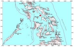
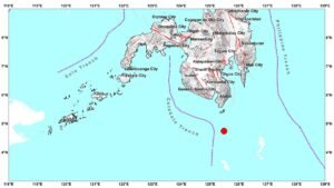
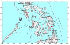
According to PHIVOLCS-DOST, the tremor’s epicenter was positioned at geographic coordinates 5.24°N, 125.39°E — roughly 20 kilometers south-southwest of Balut Island, which falls within the Municipality of Sarangani in Davao Occidental. The earthquake originated at a relatively shallow focal depth of 17 kilometers beneath the seafloor, a factor that generally increases the potential for surface-level ground motion even in lower-magnitude events.
PHIVOLCS-DOST reported the earthquake’s magnitude as Ms 5.2, where the “Ms” designation indicates that the figure was derived from surface wave measurements rather than body wave or moment magnitude calculations. The agency further classified the event as tectonic in origin, meaning it was caused by the movement and stress along geological fault structures rather than volcanic activity.
Confirmed Aftershock of the June 8 Mw7.8 Earthquake
PHIVOLCS-DOST has officially confirmed that the June 9 tremor is an aftershock of the powerful magnitude 7.8 earthquake that struck offshore Sarangani on June 8, 2026. Aftershocks, as the agency defines them, are a series of smaller earthquakes that follow a major seismic event and are typically centered in the same geographic zone as the mainshock. They can continue for days, weeks, or even months after the primary quake, gradually decreasing in frequency and intensity over time, though significant aftershocks are still possible in the immediate aftermath of a large event.
The magnitude 7.8 mainshock, which preceded this aftershock by less than 24 hours, was a major seismic event by any standard classification. Under the Richter and moment magnitude scales, a 7.8-magnitude earthquake releases enormous amounts of energy and is capable of causing widespread structural damage and triggering tsunamis when occurring offshore. PHIVOLCS-DOST has been actively monitoring the seismic sequence since the mainshock struck on June 8.
Instrumental Intensity Readings Across Three Areas
While the June 9 aftershock was strong enough to be detected by seismological instruments, PHIVOLCS-DOST reported that shaking was not felt by people in the affected areas. The agency’s bulletin recorded Intensity I readings — the lowest level on the PHIVOLCS Earthquake Intensity Scale (PEIS) — in three locations:
- Malapatan, Sarangani
- Malungon, Sarangani
- General Santos City
Under the PHIVOLCS Earthquake Intensity Scale, Intensity I describes ground motion that is imperceptible to humans under ordinary circumstances and is only detectable through seismographic instrumentation. No felt reports from residents in any of these areas were included in the agency’s official bulletin released that morning.
No Damage Expected, But More Aftershocks Likely
Despite the magnitude 5.2 reading, PHIVOLCS-DOST stated that this particular aftershock is not expected to have caused any structural damage. However, the agency issued a clear advisory to the public, warning that additional aftershocks should be anticipated following the magnitude 7.8 mainshock of June 8, 2026. The seismic sequence in the Sarangani offshore area remains active, and communities in the region have been placed on continued alert.
Aftershock sequences following major earthquakes of Mw7.8 strength are well-documented in seismological literature and can include tremors capable of causing independent damage, particularly in areas where structures may have already been weakened by the mainshock. PHIVOLCS-DOST’s advisory underscores the importance of continued vigilance even after the most intense shaking has subsided.
Public Advisory: Monitor Official Channels
PHIVOLCS-DOST urged members of the public to remain updated through the agency’s official channels rather than relying on unverified social media reports. Real-time earthquake data, intensity maps, and official bulletins are regularly published on the PHIVOLCS-DOST website at phivolcs.dost.gov.ph. Residents in areas near the epicenter or those who may have felt shaking are also encouraged to submit felt reports directly through the agency’s online reporting tools, which help scientists better map the actual reach of seismic events.
In the aftermath of a major seismic sequence like the one currently unfolding off Sarangani, PHIVOLCS-DOST plays a central role in coordinating scientific monitoring and communicating risk information to the public and to local government units. The agency operates a nationwide network of seismographic stations that allows near-real-time detection and analysis of earthquakes occurring throughout the Philippine archipelago, which sits within the Pacific Ring of Fire — one of the most seismically active regions on Earth.
Local government units in the General Santos City area and in the municipalities of Sarangani province are advised to continue coordinating with PHIVOLCS-DOST and with the National Disaster Risk Reduction and Management Council (NDRRMC) for updated guidance as the aftershock sequence progresses.
Originally reported by: PHIVOLCS-DOST bulletin and wire reports