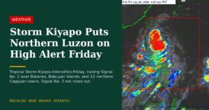
Cloudy skies, scattered thunderstorms, and elevated hazard risks descended on the western portions of Northern Luzon on Thursday, June 11, 2026, as the Southwest Monsoon — known locally as the habagat — strengthened its influence over the region. The Philippine Atmospheric, Geophysical and Astronomical Services Administration (PAGASA) identified Ilocos Norte, Batanes, and the Babuyan Islands as the areas most exposed to flash floods and landslides, while the rest of the archipelago braced for isolated rain showers driven by localized weather systems.
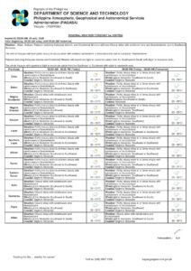
PAGASA released its 24-hour public weather forecast at 4:00 AM on Thursday, with validity running through 4:00 AM on Friday, June 12, 2026. The bulletin covers wind and sea conditions, temperature readings, and precipitation expectations for all major regions of the country.
Monsoon Dominates the North, Isolated Storms Nationwide
The habagat, a seasonal wind system that typically reaches peak intensity between June and September, is channeling warm and moisture-heavy air from the West Philippine Sea directly into the northern portion of Luzon. According to PAGASA, this makes the western section of Northern Luzon the focal point of Thursday’s most significant weather activity.
Beyond the immediate monsoon zone, PAGASA warns that localized thunderstorms can develop rapidly at virtually any point across the country — from the northern tip of Luzon down to the southernmost islands of Mindanao. These storms tend to build during the afternoon and early evening, meaning residents throughout the Philippines should monitor sky conditions through the latter half of the day.
Luzon Weather Breakdown
Ilocos Norte, Batanes, and Babuyan Islands
Communities in Ilocos Norte, the island province of Batanes, and the Babuyan Islands face the highest weather risk on Thursday. PAGASA forecasts cloudy skies with scattered rains and thunderstorms across all three areas, a direct consequence of the strengthening Southwest Monsoon pressing against the western flank of Northern Luzon.
The primary dangers cited by PAGASA are flash floods and landslides. Moderate to at times heavy rainfall can accumulate quickly over both flat, low-lying areas and steep hillside terrain. Residents living near riverbanks, along coastlines, and in hillside communities are strongly advised to stay alert and comply promptly with any evacuation orders issued by their respective local government units.
Sea conditions off the Northern Luzon coastline are also deteriorating. PAGASA reports south to southwest winds generating wave heights of 1.2 to 2.5 meters in coastal waters — a range generally considered rough and hazardous for small fishing vessels and bancas. Fisherfolk and small boat operators in the area are urged to assess sea conditions carefully before heading out.
Metro Manila and Remaining Luzon Provinces
The rest of Luzon, including Metro Manila, falls outside the Southwest Monsoon’s direct path. PAGASA forecasts partly cloudy to cloudy skies for these areas, with isolated rain showers or thunderstorms possible due to localized convective activity rather than monsoon influence.
While the threat level is considerably lower than in the far north, PAGASA emphasizes that intense thunderstorm episodes can still trigger flash floods and landslides even outside formal warning zones. Metro Manila’s low-lying barangays are particularly susceptible to rapid urban flooding during short but intense downpours, and residents are advised to stay away from flooded esteros and waterways. Winds across the rest of Luzon blow from the southeast to south at light to moderate speeds, with coastal swells ranging from 0.6 to 1.5 meters.
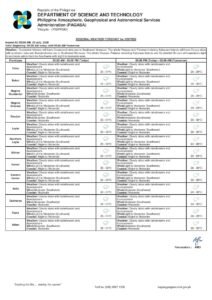
Visayas Forecast
All three Visayas sub-regions — Eastern, Western, and Central Visayas — fall under the general national forecast of partly cloudy to cloudy skies, with isolated rain showers or thunderstorms tied to localized weather systems. PAGASA notes that flash floods and landslides remain possible should any of these isolated thunderstorms become severe.
Residents in mountainous terrain and coastal communities across the Visayas, including those in Samar, Leyte, and the Negros highlands, should remain alert to sudden weather shifts throughout the day. Winds across the Visayas are light to moderate from the southeast to south, with wave heights in coastal waters running between 0.6 and 1.5 meters, according to PAGASA.
Mindanao Forecast
Mindanao likewise falls under the nationwide forecast of partly cloudy to cloudy skies with isolated rain showers or thunderstorms, driven by localized weather systems. PAGASA applies the same flash flood and landslide caution to Mindanao during periods of intense thunderstorm activity.
The island’s diverse landscape — encompassing the highland plateaus of Bukidnon, the mountainous terrain of the Davao region, and the broad floodplains of Cotabato and Lanao — makes it particularly prone to localized flooding year-round. Thursday’s isolated storm potential should therefore not be dismissed lightly. Coastal winds around Mindanao are light to moderate from the southeast to south, with sea swells at slight to moderate levels of 0.6 to 1.5 meters.
Temperature Data for Metro Manila
PAGASA’s official weather station at Science Garden in Diliman, Quezon City recorded a maximum temperature of 34.3°C at 1:00 PM on Wednesday, June 10, and a minimum of 27.4°C at 5:00 AM during the same 24-hour observation period ending at 8:00 PM. Relative humidity swung between a high of 89 percent and a low of 49 percent over that period.
These readings are consistent with typical early-June Metro Manila conditions — hot and uncomfortable in the early afternoon, with overnight temperatures remaining warm and humid. PAGASA and health authorities regularly advise residents, especially the elderly, young children, and outdoor workers, to drink sufficient water and minimize prolonged exposure to the sun during peak afternoon hours.
Tidal Data and Astronomical Notes for Metro Manila
According to PAGASA and the National Mapping and Resource Information Authority (NAMRIA), tidal predictions for Manila Bay on Thursday, June 11 are as follows: high tide of 0.87 meters at 6:46 AM, followed by a low tide of 0.34 meters at 1:41 PM, a second high tide of 0.54 meters at 7:12 PM, and a final low tide of 0.39 meters at 11:45 PM.
Sunrise over Metro Manila is set for 5:26 AM, with sunset at 6:25 PM. The moon rises at 1:33 AM and sets at 2:24 PM, displaying only 19 percent illumination — a thin crescent that will offer minimal light after dark.
Safety Precautions and Public Advisories
PAGASA’s forecast explicitly flags flash flood and landslide hazards for Ilocos Norte, Batanes, and the Babuyan Islands, while issuing a general nationwide caution for the same risks should severe thunderstorms materialize elsewhere. Residents across all regions are encouraged to observe the following safety measures.
In the most severely affected northern areas, people should avoid crossing rivers and flood-prone roads during or immediately after heavy rain. Staying away from large trees and open areas during lightning activity is also critical. Those living on or near slopes should monitor for signs of ground movement or unusual water flow that may signal an impending landslide.
For the rest of the country, PAGASA advises the public to be ready for sudden, intense downpours that can quickly overwhelm drainage systems and cause localized flooding even in areas not formally under any weather warning. Residents should keep emergency contact numbers accessible and follow advisories from local disaster risk reduction and management offices.
Mariners in Northern Luzon waters are urged by PAGASA to exercise extra caution given wave heights that may reach up to 2.5 meters. Operators of small vessels are advised to defer sea voyages until weather and sea conditions improve.
Originally reported by: wire reports