The southern waters off Davao Occidental continued to show seismic activity on Monday afternoon when a magnitude 4.8 earthquake struck offshore, adding to a series of aftershocks that have followed two powerful tremors earlier in June 2026. The Philippine Institute of Volcanology and Seismology (PHIVOLCS-DOST) logged the event and confirmed that neither damage nor additional aftershocks are anticipated from this particular occurrence.
Details of the Tremor
According to PHIVOLCS-DOST, the earthquake was recorded at exactly 12:14:31 PM Philippine Standard Time on June 29, 2026. The agency classified it as a tectonic earthquake, meaning it originated from natural movement along fault structures beneath the seabed rather than from volcanic or man-made causes.
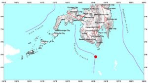
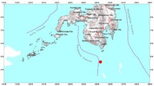
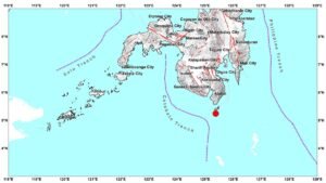
The epicenter was pinpointed at geographic coordinates 4.59°N, 125.04°E — approximately 101 kilometers south-southwest of Balut Island in the Municipality of Sarangani, Davao Occidental. PHIVOLCS-DOST recorded the event at a focal depth of 31 kilometers beneath the surface and assigned it a surface-wave magnitude of Ms 4.8.
Part of a Larger Seismic Sequence
This tremor does not stand alone. PHIVOLCS-DOST identified the June 29 earthquake as an aftershock tied to two earlier, more destructive earthquakes — specifically the Mw7.8 Offshore Sarangani earthquake and the Mw6.5 Offshore Davao Occidental earthquake, both of which occurred earlier in June 2026. These two events together set off a seismic sequence that has continued to produce smaller tremors in the weeks that followed.
Aftershock sequences of this nature are scientifically expected following major earthquakes. As the Earth’s crust adjusts to the stress redistribution caused by the initial ruptures, smaller earthquakes continue to occur in the surrounding area. The June 29 event represents one of the latest tremors in this ongoing pattern, as described in PHIVOLCS-DOST’s official bulletin.
No Felt Shaking, No Damage Reported
Despite being a moderately sized tremor, the June 29 earthquake did not generate any felt reports under the PHIVOLCS Earthquake Intensity Scale. The bulletin released by PHIVOLCS-DOST contained no reports of shaking experienced by residents in any nearby community.
The agency’s assessment was clear: no structural damage is expected, and the probability of this specific event triggering further aftershocks is considered low. The relatively deep focal depth of 31 kilometers, combined with the offshore epicenter more than 100 kilometers from Balut Island, likely contributed to the minimal surface impact of the tremor.
Official Bulletin and Monitoring
PHIVOLCS-DOST formally issued Earthquake Information No. 2 for this event at 12:51 PM PHT on June 29, 2026 — approximately 37 minutes after the quake was detected. The agency noted in its bulletin that this would serve as the only information release for the event, unless new or significant developments warrant a follow-up report. An epicentral map was also made available alongside the official bulletin to help the public visualize the location of the earthquake in relation to populated areas.
For communities in southern Mindanao and nearby coastal areas, PHIVOLCS-DOST continues to recommend monitoring official updates at phivolcs.dost.gov.ph as the aftershock sequence from the earlier Mw7.8 and Mw6.5 events remains technically active. The public is encouraged to stay alert and be prepared for the possibility of additional tremors, though the agency has not raised any alarm level for the June 29 event specifically.
Seismologists note that aftershock sequences following earthquakes of magnitude 7.0 or above can persist for weeks or even months, gradually decreasing in both frequency and intensity over time. The continuing activity in the Sarangani offshore area is consistent with this pattern, according to standard seismological understanding referenced in PHIVOLCS-DOST’s public advisories.
By the Numbers
- Ms 4.8 — surface-wave magnitude of the June 29 aftershock
- 31 km — focal depth of the earthquake
- 101 km — distance of the epicenter south-southwest of Balut Island
- Mw7.8 — magnitude of the primary Offshore Sarangani earthquake earlier in June 2026
- Mw6.5 — magnitude of the secondary Offshore Davao Occidental earthquake
- 12:14:31 PM — exact time the June 29 quake was recorded
- 12:51 PM PHT — time PHIVOLCS-DOST issued the official bulletin
Why This Matters
The persistence of aftershocks following the Mw7.8 and Mw6.5 earthquakes earlier in June 2026 signals that the seismic sequence in the Sarangani offshore zone has not yet fully subsided. While the June 29 tremor caused no felt shaking or damage, it serves as a reminder that communities in southern Mindanao remain within a seismically active period. PHIVOLCS-DOST’s continued monitoring and timely bulletins are essential for keeping the public accurately informed and prepared for any escalation in activity.
Source: PHIVOLCS-DOST via wire reports