Friday evening on June 26, 2026, ground shaking spread rapidly across southern and central Mindanao after a powerful tectonic earthquake measuring magnitude 6.5 struck waters south of Sarangani province. The Philippine Institute of Volcanology and Seismology of the Department of Science and Technology (PHIVOLCS-DOST) confirmed the event and indicated that while no structural damage is expected, residents should brace for aftershocks in the coming hours and days.
Quake Details and Location
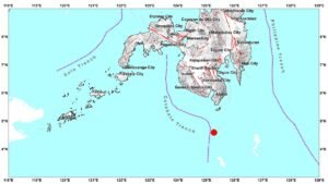
According to PHIVOLCS-DOST, the earthquake occurred at exactly 7:34:35 in the evening, Philippine Standard Time (PHT). The agency placed its epicenter approximately 70 kilometers south-southwest of Balut Island, which falls under the Municipality of Sarangani in Davao Occidental. Geographic coordinates were recorded at 4.82°N, 125.21°E, with the quake originating at a focal depth of 38 kilometers beneath the earth’s surface.
PHIVOLCS-DOST classified the earthquake as tectonic in origin, meaning natural stress and movement along fault structures within the earth’s crust caused the release of seismic energy — as opposed to volcanic or human-induced activity.
The information cited here comes from Earthquake Information No. 3, released by PHIVOLCS-DOST on June 27, 2026, at 11:50 AM PHT. The agency noted that this bulletin would be the final one issued for this event unless new data warrants an update. An epicentral map was included with the official release, available at phivolcs.dost.gov.ph.
Shaking Intensity Across Affected Areas
PHIVOLCS-DOST uses the PHIVOLCS Earthquake Intensity Scale (PEIS) to classify how strongly ground motion was experienced in specific communities. The quake registered varying intensity levels across dozens of municipalities, towns, and cities in Mindanao and the BARMM.
Intensity V — Strong
The most intense shaking, classified as Intensity V under the PEIS — a level at which nearly all residents feel the motion and some may rush outside — was observed in several communities. In Sarangani province, strong shaking was felt in Kiamba, Malapatan, Malungon, and Alabel. The City of General Santos also experienced this level of ground motion, as did Lake Sebu and T’boli in South Cotabato, and Palimbang in Sultan Kudarat.
Instrumental data from PHIVOLCS-DOST confirmed Intensity V readings in Kiamba and Malapatan (Sarangani) and T’boli (South Cotabato).
Intensity IV — Moderately Strong
One step below, Intensity IV shaking — noticeable to most people and sufficient to cause hanging objects to swing clearly — was felt across a wider geographic band. Affected areas included Glan, Maasim, and Maitum in Sarangani; Don Marcelino and Santa Maria in Davao Occidental; the City of Davao; Matanao in Davao del Sur; and the City of Koronadal, Polomolok, and Tupi in South Cotabato.
Instrument-based readings from PHIVOLCS-DOST validated Intensity IV shaking in General Santos City; in Malungon, Maitum, Kiamba, and Maasim in Sarangani; and in Tupi and Koronadal City in South Cotabato.
Intensity III — Weak to Moderate
Across a yet broader swath, Intensity III shaking was reported. This included portions of Davao del Sur and the City of Davao; multiple towns in South Cotabato such as Tampakan, Norala, Banga, Tantangan, Santo Niño, and Surallah; the City of Kidapawan and Makilala in Cotabato; several Sultan Kudarat municipalities including Tacurong City, President Quirino, Lebak, Bagumbayan, Lutayan, and Esperanza; the City of Zamboanga; and Lamitan City and Isabela City in Basilan.
PHIVOLCS-DOST’s instrumental records confirmed Intensity III in Santa Maria (Davao Occidental); Banga, Surallah, Santo Niño, and Tampakan (South Cotabato); Kidapawan City (Cotabato); and Palimbang, President Quirino, Esperanza, and Lebak (Sultan Kudarat).
Intensity II — Slightly Felt
Intensity II shaking — perceptible mainly to those who are resting or in upper floors — extended to Monkayo, Mawab, Nabunturan, and Maragusan in Davao de Oro; the City of Digos in Davao del Sur; M’lang, Magpet, and Antipas in Cotabato; Columbio in Sultan Kudarat; Datu Blah T. Sinsuat, Datu Odin Sinsuat, and Sultan Kudarat municipality in Maguindanao del Norte; Kapatagan in Lanao del Norte; and Jolo in Sulu.
Instrumental readings confirmed Intensity II in Magsaysay (Davao del Sur); Norala (South Cotabato); Isulan and Kalamansig (Sultan Kudarat); M’lang and Magpet (Cotabato); and Columbio (Sultan Kudarat), as reported by PHIVOLCS-DOST.
Intensity I — Barely Perceptible
At the farthest range, Intensity I — detectable only through seismic instruments or by very few individuals under highly sensitive conditions — was reported in Alamada and Carmen in Cotabato; Senator Ninoy Aquino in Sultan Kudarat; and San Fernando and Kalilangan in Bukidnon. Instrument data confirmed Intensity I in President Roxas and Carmen in Cotabato.
Damage Outlook and Aftershock Warning
Despite the quake’s magnitude and the breadth of areas where shaking was felt, PHIVOLCS-DOST assessed that no damage is expected from this seismic event. The agency nonetheless cautioned the public that aftershocks are anticipated and advised residents — particularly those in highly affected municipalities — to remain alert and to follow guidance from local disaster risk reduction and management offices.
By the Numbers
- 6.5 — Magnitude of the earthquake
- 7:34:35 PM PHT, June 26, 2026 — Exact time of the event
- 70 km — Distance of the epicenter south-southwest of Balut Island, Sarangani, Davao Occidental
- 38 km — Focal depth of the earthquake
- 4.82°N, 125.21°E — Recorded geographic coordinates of the epicenter
- 5 — Highest intensity level (Intensity V) recorded, covering General Santos City and several Sarangani municipalities
- June 27, 2026, 11:50 AM PHT — Time of PHIVOLCS-DOST Earthquake Information No. 3 bulletin issuance
Why This Matters
A magnitude 6.5 earthquake is considered strong and capable of causing significant damage in densely populated or poorly constructed areas, making PHIVOLCS-DOST’s rapid assessment and public bulletins critical for informed community response. The wide geographic spread of shaking — from Davao Occidental in the south to Bukidnon in the north and as far west as Zamboanga City and Sulu — underscores the quake’s substantial reach across Mindanao and the BARMM. The confirmed expectation of aftershocks means that affected communities must remain on alert, as secondary tremors can cause additional stress to structures and heighten risks for residents already unsettled by the main event.
Source: PHIVOLCS-DOST Earthquake Information No. 3, June 27, 2026