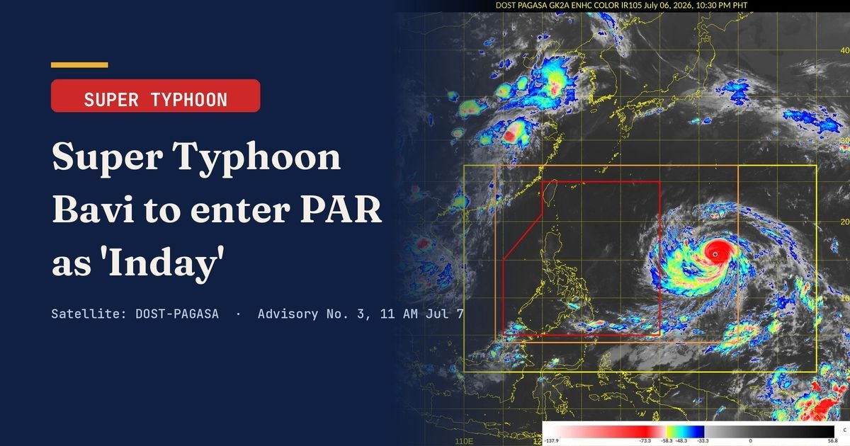
Super Typhoon Bavi is bearing down on the Philippines and is expected to breach the Philippine Area of Responsibility (PAR) sometime between the evening of Tuesday, July 7, and the early hours of Wednesday, July 8 — at which point the state weather bureau will officially designate it with the local name Inday. The announcement came through PAGASA’s Tropical Cyclone Advisory No. 3, released at 11 a.m. on Tuesday.
Wind signals could be hoisted over the northern and eastern sections of Northern Luzon as early as Tuesday evening, PAGASA warned. The weather bureau also did not dismiss the possibility of wind signals eventually being extended to certain areas of Southern Luzon and the Visayas, depending on how the storm’s track and intensity evolve in the coming hours.
Where the Storm Stands Right Now
At 10 a.m. Tuesday, July 7, PAGASA placed the eye of Super Typhoon Bavi at roughly 1,845 kilometers east of Central Luzon, at coordinates 16.2°N, 139.4°E — a position still far outside the PAR boundary. The agency noted that Bavi had undergone a slight weakening but remained on a west-northwestward trajectory.
Despite that modest dip in strength, the super typhoon still carried maximum sustained winds of 185 km/h near its center, with destructive gusts reaching as high as 230 km/h. Its central pressure was recorded at 930 hPa, and the system was advancing west-northwestward at a forward speed of 20 km/h. Perhaps most striking, according to PAGASA, was the sheer breadth of the storm: strong to typhoon-force winds extended outward up to 800 kilometers from its center, giving the system an enormous footprint even before it reaches Philippine territory.
Projected Path: Northern Luzon in the Crosshairs
PAGASA’s forecast track places Extreme Northern Luzon as the portion of the country most directly in Bavi’s path. The weather bureau expects the typhoon to retain its super typhoon classification upon entering PAR, with gradual weakening projected as it draws closer to Extreme Northern Luzon and the area east of Taiwan.
While a direct landfall over any part of Luzon carries a low probability, PAGASA cautioned that this does not significantly reduce the hazards the storm poses. The highest wind signal anticipated during the typhoon’s passage over or near Northern Luzon is Signal No. 2 or Signal No. 3, the bureau said in its advisory.
Broad Weather Watch Coverage Across the Country
PAGASA’s advisory laid out a day-by-day schedule of areas under weather watch as the storm progresses westward:
- Tuesday, July 7: Most of Mindanao
- Wednesday, July 8: Pangasinan, Zambales, Bataan, Cavite, Batangas, most of MIMAROPA, most of the Bicol Region, most of the Visayas, and most of Mindanao
- Thursday, July 9: Most of the country
The weather bureau emphasized that the list of areas under weather watch could be revised as new data refines the typhoon’s track. The eastern sections of Southern Luzon and the Visayas, in particular, remain subject to possible wind signal upgrades.
Southwest Monsoon Compounds the Threat
A key aggravating factor, according to PAGASA, is the enhanced Southwest Monsoon interacting with the outer rainbands of the super typhoon. Together, these systems are expected to push strong to gale-force gusts across broad stretches of the archipelago — not only along the storm’s direct path but in areas far removed from the center. Coastal and upland zones were specifically flagged by the bureau as facing heightened exposure to these wind hazards.
Marine Hazards: Gale Warnings Coming
For those with sea travel planned over the next several days, PAGASA issued a clear caution. A Gale Warning associated with rough to very rough seas is expected to be issued by Wednesday covering the northern and eastern seaboards of the Philippines. The bureau urged the public and disaster risk reduction offices at all levels to maintain close watch on successive advisories as Bavi approaches and enters PAR.
Maritime travelers and coastal communities are strongly advised to check the latest PAGASA bulletins before any scheduled sea departures, the advisory stated.
When to Expect the Next Update
PAGASA’s next scheduled Tropical Cyclone Advisory is set for release at 11 p.m. on Tuesday, July 7. However, the agency indicated that an earlier intermediate advisory may be issued if there are substantial developments in the storm’s track or intensity before that time.
By the Numbers
- 1,845 km — distance of Bavi’s eye from Central Luzon as of 10 a.m., July 7
- 185 km/h — maximum sustained winds near the center
- 230 km/h — peak wind gusts
- 930 hPa — central pressure at time of advisory
- 800 km — radius of strong to typhoon-force winds from the center
- 20 km/h — forward movement speed, heading west-northwest
- Signal No. 2 or 3 — highest wind signal expected during passage over Northern Luzon
Why This Matters
Super Typhoon Bavi’s enormous wind field — stretching 800 kilometers from its center — means millions of Filipinos across multiple regions face real wind and sea hazards regardless of whether the storm makes a direct landfall over Luzon. The simultaneous enhancement of the Southwest Monsoon by the typhoon’s outer bands widens the danger zone further, placing coastal communities, upland areas, and maritime travelers across Luzon, the Visayas, and Mindanao on alert from Tuesday through Thursday. PAGASA’s call for continuous monitoring by disaster risk reduction offices and the general public reflects the scale and complexity of the threat this system presents as it moves toward PAR.
Source: PAGASA / breakingnewsnegrosoriental.com