A forecast of intermittent rain and possible thunderstorms is set to define Monday, July 6, 2026, for Negros Oriental, Siquijor, and the rest of the Visayas region — with the Philippine Atmospheric, Geophysical and Astronomical Services Administration (PAGASA) warning that while conditions are not extreme, they are unsettled enough to warrant genuine caution, especially for those working at sea or in open fields.
PAGASA released its Regional Forecast for the Visayas at 5:00 AM on July 6, describing a day of partly cloudy to at times cloudy skies, punctuated by rainshowers or thunderstorms that could develop at any point during the day. The agency noted that no tropical cyclone wind signals are currently in effect for the region, but emphasized that the absence of a named storm does not eliminate weather risk.
Monday’s Forecast in Detail
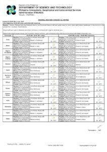
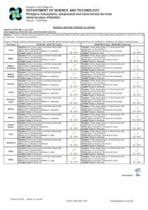
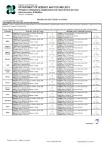
According to PAGASA, temperatures across Negros Oriental on Monday will hover between a low of 27°C and a high of 32°C — consistent with the warm, humid conditions typical of the Visayas during the height of the rainy season. The forecast describes the sky as partly cloudy to at times cloudy, with rainshowers or thunderstorms likely to develop as the day progresses.
Winds on Monday will blow from the northwest to southwest at light to moderate speeds. Coastal waters have been rated as slight to moderate by the agency, meaning seas are active but not categorically dangerous for larger vessels under normal circumstances. Still, PAGASA cautions that thunderstorms can rapidly deteriorate sea conditions, making vigilance essential for all maritime activities.
Neighboring provinces, including Siquijor Island and Cebu, fall under the same regional forecast and can expect broadly similar weather throughout the day, the agency confirmed.
No Named Weather System, but Rain Remains Likely
PAGASA’s forecast data for July 6 does not attribute Monday’s unsettled conditions to a specific weather system such as the southwest monsoon (habagat), a low-pressure area, or a tropical cyclone. What the agency does confirm is that the atmosphere over the Visayas is sufficiently moist and unstable to support the formation of rain clouds and thunderstorm cells throughout the day.
This pattern is consistent with the broader Philippine rainy season, when convective activity — driven by heat and moisture rather than a named storm — can produce sudden and significant downpours, particularly during the afternoon hours. Residents in Dumaguete and other communities in Negros Oriental should not be lulled into complacency by a dry morning, as conditions can shift quickly.
By the Numbers
- Forecast temperature low: 27°C (Monday, July 6)
- Forecast temperature high: 32°C (Monday, July 6)
- PAGASA forecast issued: 5:00 AM, July 6, 2026
- Extended outlook issued: 9:00 AM, July 5, 2026
- Sunday temperature range: 26°C–32°C
- Tuesday temperature range: 26°C–32°C
A Look at the Week Ahead
PAGASA’s Extended Weather Outlook, which the agency issued at 9:00 AM on July 5, 2026, projects similar conditions stretching into the early part of the week. The outlook covers three consecutive days:
- Sunday (passed): Temperatures ranging from 26°C to 32°C, with light to moderate winds blowing from the northeast to southeast and slight to moderate coastal waters.
- Monday (today): Temperatures again between 26°C and 32°C, with winds shifting to the northwest to southwest direction and coastal seas rated slight to moderate.
- Tuesday: Temperatures maintaining the 26°C to 32°C range, with winds turning toward the west and coastal conditions remaining at slight to moderate.
The progressive shift in wind direction — moving from the northeast-southeast axis on Sunday, to northwest-southwest on Monday, and then purely westward by Tuesday — points to a slowly evolving atmospheric pattern over the region. According to PAGASA’s data, no dramatic worsening is anticipated in the immediate short-term, but intermittent showers and thunderstorms are expected to persist into the early days of the week.
No Active Warnings — Caution Still Warranted
As of the 5:00 AM July 6 forecast, PAGASA confirmed it has not issued tropical cyclone wind signals, gale warnings, or rainfall warnings for Negros Oriental or the broader Visayas. This means the day is not classified as severely dangerous under current conditions.
Nevertheless, the agency’s inclusion of thunderstorms in the forecast carries real implications. Even without a named cyclone, thunderstorms in the Philippines can produce concentrated, intense rainfall in short periods, sudden wind gusts, lightning strikes, and localized flooding — particularly in low-lying barangays and communities with constrained drainage capacity. Areas such as Dumaguete, Bais, Bayawan, and Guihulngan in Negros Oriental are among those where localized flooding can develop rapidly when a strong thunderstorm cell passes through.
Guidance for Specific Sectors
Ferry Passengers and Inter-Island Travelers
PAGASA’s classification of coastal waters as slight to moderate generally permits larger inter-island vessels — including fast ferries and roll-on/roll-off (RORO) ferries serving routes out of Dumaguete port to Siquijor, Cebu, Dapitan, and other destinations — to continue operating. However, the agency’s thunderstorm forecast means conditions could deteriorate without much advance notice over the Bohol Sea or Tañon Strait.
Passengers with Monday bookings on these routes are advised to confirm schedules directly with their shipping line before traveling to the port, check for any coast guard advisories issued closer to departure, and factor in the possibility of weather-related delays. Operators and passengers of smaller outrigger boats and pumpboats — especially those crossing to Siquijor — should exercise heightened caution, as slight-to-moderate seas that are manageable for large vessels can feel considerably rougher aboard a small craft.
Fisherfolk and Coastal Communities
For fishing communities along the Negros Oriental coastline — from Bayawan in the south to Bais and Guihulngan on the eastern shore — PAGASA’s thunderstorm risk carries particular weight. Coastal waters rated slight to moderate remain workable for experienced mariners with appropriately sized vessels, but the possibility of rapidly forming thunderstorms throughout the day means sea conditions can deteriorate quickly.
Lightning at sea is a serious and underappreciated hazard. Fisherfolk are encouraged to head out early and plan their return to shore well before the afternoon, when convective thunderstorm activity typically peaks. At the first sign of darkening skies or approaching rain bands, mariners should head for port without delay.
Farmers and Agricultural Workers
Farmers tending sugar cane, rice paddies, vegetable plots, and other crops across Negros Oriental will find Monday’s forecast a mixed picture. The intermittent rainshowers can provide useful natural irrigation during the mid-rainy season, easing dependence on supplemental watering. However, strong thunderstorms pose a risk of localized crop damage, particularly for young seedlings and vegetable plots vulnerable to heavy rain and wind.
Agricultural workers in open fields should seek shelter immediately upon signs of an approaching thunderstorm, given the lightning risk. PAGASA’s data also suggests farmers delay any scheduled pesticide or fertilizer applications until after rainfall passes, as runoff from heavy rain will significantly reduce the effectiveness of such treatments. Checking drainage channels around fields to prevent waterlogging is also advisable ahead of a day of intermittent showers.
Why This Matters
PAGASA’s forecast of rainshowers and thunderstorms across Negros Oriental and the Visayas on July 6 carries real consequences for the region’s maritime, agricultural, and daily commuter sectors. Though no formal warnings have been issued, the thunderstorm risk means conditions can shift from manageable to hazardous in a short time — particularly at sea and in low-lying areas prone to flash flooding. Residents, fisherfolk, and travelers across the region should monitor updates from PAGASA throughout the day and adjust plans accordingly rather than rely solely on morning conditions as a guide for the rest of the day.
Source: Breaking News Negros Oriental (breakingnewsnegrosoriental.com)