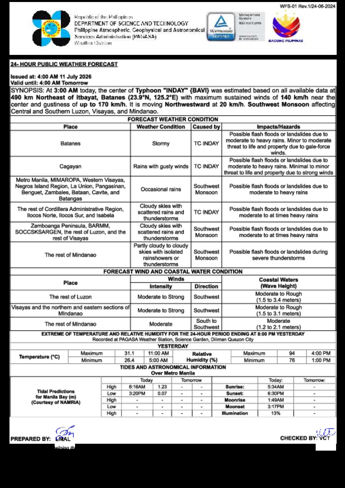
Saturday, July 11, 2026 — A powerful typhoon churning far to the northeast and a fully active southwest monsoon are conspiring to deliver unsettled, wet, and in some areas dangerous weather to virtually every corner of the Philippine archipelago today. The Philippine Atmospheric, Geophysical and Astronomical Services Administration (PAGASA) released its 4:00 AM weather bulletin laying out the combined impact of these two systems — a scenario that stretches weather hazards from the storm-battered tip of Batanes all the way down to the southernmost reaches of Mindanao.
Two Systems, One Rainy Saturday
PAGASA’s early-morning forecast identifies two separate drivers behind today’s widespread wet weather. The first is Typhoon Inday, known internationally as Bavi. As of 3:00 AM Saturday, the typhoon’s center was tracked approximately 1,490 kilometers northeast of Itbayat, Batanes — well outside Philippine territory, but close enough for its outer rain bands to batter the northernmost province and pump additional moisture into Cagayan Valley.
At that position, PAGASA reported Typhoon Inday was packing maximum sustained winds of 140 km/h near its eye, with gusts surging to 170 km/h. The system was moving in a northwestward direction at 20 km/h. While the typhoon is not on a direct track toward the Philippine landmass, its size and intensity are sufficient to generate dangerous conditions hundreds of kilometers from its center.
The second driver is the southwest monsoon — locally called the habagat — a seasonal wind pattern that draws warm, moisture-heavy air from the sea across the western flanks of Luzon and the Visayas. According to PAGASA, the habagat is currently affecting Central and Southern Luzon, the Visayas, and Mindanao, making it the dominant weather force for the majority of the country today even as Typhoon Inday commands attention in the far north.
By the Numbers
- 1,490 km — distance of Typhoon Inday’s center from Itbayat, Batanes, as of 3:00 AM Saturday
- 140 km/h — maximum sustained winds near Typhoon Inday’s center
- 170 km/h — peak gusts generated by Typhoon Inday
- 20 km/h — the typhoon’s northwestward movement speed
- 1.5 to 3.1 meters — forecast wave heights along western Luzon, all sides of Visayas, and parts of Mindanao
How Each Region Is Affected
Northern Luzon: The Hardest Hit
PAGASA’s bulletin reserves its most severe language for Batanes, which is forecast to face stormy conditions directly attributable to Typhoon Inday. Gale-force winds and heavy rain are expected to pose genuine threats to life and property. Residents there are advised to stay indoors, keep away from windows, and avoid flood-prone zones entirely.
Cagayan province is under a slightly lower threat level — PAGASA describes the outlook as rains with gusty winds, also driven by Typhoon Inday’s influence. Flash floods and landslides are possible, and the wind-driven damage risk — though classified as minimal to minor — is still real enough that residents should secure loose items outside their homes and avoid unnecessary travel.
The rest of the northern regions tell a more layered story. The Cordillera Administrative Region (CAR), Ilocos Norte, Ilocos Sur, and Mountain Province are caught between the two systems — Typhoon Inday’s reach from the east and the habagat pushing from the southwest — leaving them with cloudy skies, scattered to moderate rainfall, and exposure to both flash flood and landslide hazards as well as strong wind threats.
Central and Southern Luzon: Monsoon-Driven Rain
Metro Manila commuters and residents of MIMAROPA, La Union, Pangasinan, Benguet, Zambales, Bataan, Cavite, and Batangas are all under the southwest monsoon’s influence, according to PAGASA. The agency forecasts occasional rains for these areas, with flash floods and landslides remaining a possibility wherever moderate to heavy downpours materialize in mountainous or low-lying terrain. Residents near waterways, drainage channels, or hillside communities are urged to stay alert.
The remainder of Luzon not specifically named in the bulletin can expect cloudy skies with scattered rainshowers or thunderstorms — still courtesy of the habagat — with the same flash flood and landslide cautions applying.
Visayas: Widespread Monsoon Influence
Western Visayas and the Negros Island Region — which encompasses Negros Oriental and Negros Occidental — are listed in PAGASA’s forecast as falling under the southwest monsoon’s influence, with occasional rains and the associated flash flood and landslide risks. The rest of the Visayas, including Eastern Visayas and Central Visayas, can expect cloudy skies with scattered rainshowers or thunderstorms, also monsoon-driven. Residents across all Visayas sub-regions are advised to exercise the same level of caution regarding sudden heavy rainfall.
Mindanao: Isolated but Real Threats
PAGASA places the Zamboanga Peninsula, BARMM (Bangsamoro Autonomous Region in Muslim Mindanao), and SOCCSKSARGEN under cloudy skies with scattered rainshowers or thunderstorms linked to the habagat. The rest of Mindanao is forecast to see partly cloudy to cloudy conditions with isolated rainshowers or thunderstorms. While the overall intensity is lower than what northern Luzon is enduring, the weather agency warns that severe localized thunderstorms can still trigger flash floods and landslides, and residents should not treat the forecast as a clearance to be complacent.
Sea Conditions: Dangerous for Small Vessels
Beyond the rainfall and wind hazards onshore, PAGASA has flagged dangerous maritime conditions for today. The agency reports the following sea state outlook:
- Western Luzon coast: Moderate to strong winds; rough seas with wave heights of 1.5 to 3.1 meters.
- All sides of Visayas and coastal Mindanao: Moderate to strong southwest winds; moderate to rough seas reaching 1.5 to 3.1 meters.
- Eastern Luzon coast: Also affected by the dual weather systems — mariners are strongly urged to consult the latest PAGASA maritime advisories before setting out.
Wave heights in the 1.5-to-3.1-meter range are considered life-threatening for small fishing craft and bancas. PAGASA strongly advises that operators of small vessels stay ashore for the duration of these conditions. Even medium-sized vessels should exercise extreme caution.
Making Sense of the Hazard Warnings
PAGASA’s bulletin deploys several distinct warning phrases, each carrying a specific risk level that residents should understand clearly.
Flash flood and landslide warnings appear across almost every region in today’s forecast. As PAGASA explains, this hazard can materialize even when local rainfall seems moderate — upstream or upslope rain can rapidly swell rivers, creeks, and drainage channels with little warning. Anyone living near waterways or on hillsides should have an evacuation plan ready and monitor water levels closely.
“Stormy conditions” — applied to Batanes — is the most serious forecast category in today’s bulletin. It signals dangerous wind speeds combined with heavy rain capable of disrupting transportation, damaging structures, and making outdoor movement hazardous. Residents in Batanes have been strongly advised to remain indoors.
“Rains with gusty winds” in Cagayan describes a step below stormy — still capable of bringing down tree branches, snapping power lines, and damaging light structures. Residents are encouraged to secure loose property and limit travel.
Rough seas along western and southern coastal areas reinforce PAGASA’s warnings to the fishing community: the ocean today is not safe for small-craft operations.
Practical Reminders for the Day
For commuters in Metro Manila, the Ilocos Region, CAR, Cagayan Valley, and across the Visayas and Mindanao, PAGASA’s forecast means wet conditions are likely through both the morning and afternoon hours. A sturdy rain jacket or umbrella is essential. Low-lying roads are at elevated risk of flooding, particularly in areas historically prone to inundation.
Residents in coastal communities, riverside barangays, and areas near steep slopes should stay informed through official PAGASA channels and local disaster risk reduction offices. Do not wait for floodwaters to rise before moving to higher ground — early action saves lives.
Why This Matters
The simultaneous activity of Typhoon Inday and the southwest monsoon demonstrates how compound weather events can stretch emergency response resources across the entire Philippine archipelago at once, from Batanes in the extreme north to Mindanao in the south. The rough seas forecast — with wave heights of up to 3.1 meters — pose an immediate livelihood and safety threat to the country’s large fishing population, many of whom depend on daily catches. Widespread flash flood and landslide warnings across nearly all regions underscore the need for continuous public vigilance and readiness throughout the duration of these overlapping weather systems.
Source: PAGASA / Breaking News Negros Oriental source monitoring