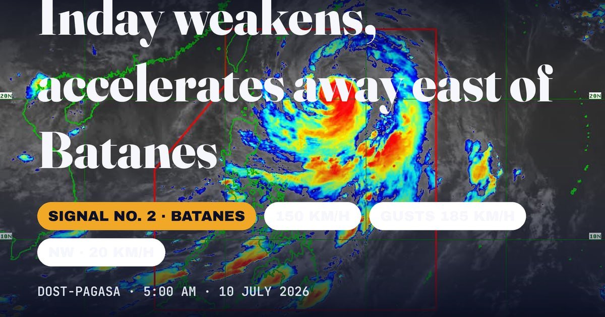
Even as it continues to lose strength, Typhoon Inday — known internationally as Bawi — still poses a significant threat to Northern Luzon and surrounding waters, with DOST-PAGASA maintaining active wind signals and gale warnings as of its 5 a.m. bulletin on Friday, July 10, 2026.
The state weather bureau reported that Inday’s center was positioned 620 kilometers east of Basco, Batanes, as of 4 a.m. Friday. The typhoon was tracking northwestward at a forward speed of 20 kilometers per hour, carrying maximum sustained winds of 150 kph near its center and gusts peaking at 185 kph. Its central pressure was recorded at 955 hectopascals, according to PAGASA’s bulletin.
Wind Signal Coverage Across Northern Luzon
DOST-PAGASA placed Tropical Cyclone Wind Signal No. 2 over Batanes, the eastern portion of the Babuyan Islands, and the northeastern section of mainland Cagayan — including the municipality of Santa Ana. Under Signal No. 2, gale-force winds ranging from 62 to 88 kph are expected to affect these areas within 24 hours, with the weather bureau warning of minor to moderate risks to life and property.
Signal No. 1, which covers strong winds between 39 and 61 kph, was in effect across a broader belt of Northern Luzon. Affected areas under this lower signal included the rest of the Babuyan Islands, the remainder of mainland Cagayan, Isabela, Apayao, the northern portion of Abra, Kalinga, the eastern portion of Mountain Province, the eastern portion of Ifugao, and Ilocos Norte.
Path of the Storm: Closest Pass Friday Night, Departure by Saturday
According to PAGASA, Typhoon Inday is forecast to remain over the Philippine Sea as it continues its northwestward track. The typhoon’s closest approach to extreme Northern Luzon is expected to occur between Friday night and early Saturday morning, after which it will head toward the southern islands of Japan.
PAGASA said the storm may make landfall or pass near the northern coastline of Taiwan after clearing Philippine waters. It is then projected to strike the eastern coast of mainland China by Saturday evening or the early hours of Sunday, at which point it is expected to have weakened to severe tropical storm intensity as it pushes further inland.
The weather bureau indicated that Inday is likely to exit the Philippine Area of Responsibility by Saturday morning or afternoon. PAGASA cautioned, however, that heavy rainfall and destructive winds could still be felt outside the official forecast track, and that the storm’s path remains subject to adjustment within the confidence cone.
Strengthened Habagat to Spread Hazardous Winds Across the Philippines
Beyond the wind signal areas in the north, DOST-PAGASA warned that the southwest monsoon — intensified by Inday’s outer circulation — will drive strong to gale-force wind gusts across the majority of the country on Friday and Saturday. This interaction between the typhoon and the habagat extends the storm’s effective reach far beyond Luzon.
By Sunday, the weather bureau said strong gusts are expected to affect most of Luzon and the Visayas, as well as portions of Mindanao, specifically Zamboanga del Norte, Misamis Occidental, Lanao del Norte, Camiguin, and Davao Oriental. Coastal and elevated areas exposed to these winds face the greatest risk, PAGASA noted.
Perilous Maritime Conditions From Batanes to Isabela
A gale warning remained active over the northern and eastern seaboards of Luzon on Friday morning. DOST-PAGASA forecast wave heights of up to 7 meters along the northern and eastern coastlines of Batanes — conditions the agency classified as phenomenal and extremely dangerous for all types of watercraft.
Very rough seas were also forecast around the Babuyan Islands and along the coasts of mainland Cagayan and Isabela. PAGASA strongly urged vessel operators to stay in port or find safe harbor rather than risk sailing through these dangerous waters until conditions improve significantly.
Operators of small watercraft, including motorbancas, were specifically advised by PAGASA to avoid navigating rough and moderately rough seas, which extended across a wide swath of Philippine waters as of Friday morning.
Advisories for Flood-, Landslide-, and Storm Surge-Prone Communities
DOST-PAGASA called on residents living in areas vulnerable to flooding, landslides, and storm surge to stay closely updated on official advisories. The agency urged compliance with evacuation orders and other directives from local government units in affected provinces.
The agency’s warnings about strong to gale-force gusts affecting coastal and upland communities through the weekend underscore how widely Typhoon Inday’s influence is felt across the archipelago, even as the storm’s core moves away from the Philippine landmass and continues to weaken. PAGASA said its next update was scheduled for release at 11 a.m. on Friday, July 10, 2026.
By the Numbers
- 620 km — Distance of Inday’s center east of Basco, Batanes, as of 4 a.m. Friday
- 150 kph — Maximum sustained winds near the typhoon’s center
- 185 kph — Peak gusts recorded near the center
- 955 hPa — Central pressure of the typhoon
- 20 kph — Forward movement speed of the storm
- 7 meters — Maximum forecast wave height off Batanes’ northern and eastern seaboards
- 62–88 kph — Gale-force wind range under Signal No. 2
- 39–61 kph — Strong wind range under Signal No. 1
Why This Matters
Typhoon Inday’s gradual weakening does not eliminate the widespread danger it presents to the Philippines. The enhanced southwest monsoon it is fueling is expected to push hazardous wind conditions across Luzon, the Visayas, and parts of Mindanao well into the weekend — long after the storm’s center exits the Philippine Area of Responsibility. Seas of up to 7 meters off Batanes represent an extreme risk to maritime safety, while communities across multiple regions remain exposed to flooding, landslides, and storm surge even as Inday tracks toward Taiwan and mainland China.
Source: DOST-PAGASA / breakingnewsnegrosoriental.com