DUMAGUETE CITY, Negros Oriental — Sunday, August 2, 2026 will be a wet and unsettled day for Negros Oriental and the rest of the Visayas, with the Philippine Atmospheric, Geophysical and Astronomical Services Administration (PAGASA) placing the entire region under a forecast of intermittent rainshowers and possible thunderstorms from morning through evening. The weather bulletin was released at 5:00 AM on August 2, 2026, covering the full Visayas cluster including Negros Oriental, Siquijor, Cebu, and provinces across Eastern and Western Visayas.
PAGASA’s Official Forecast for the Day
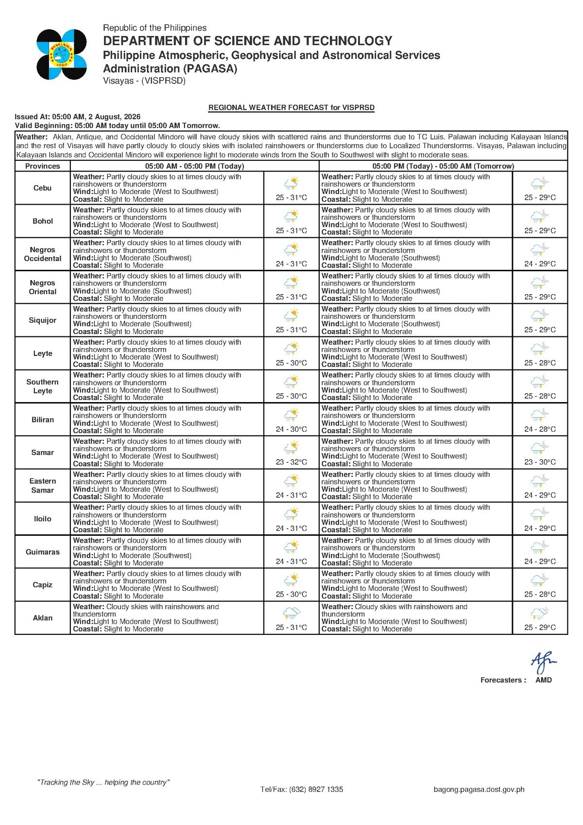
PAGASA’s regional bulletin describes conditions across the Visayas on Sunday as “partly cloudy to at times cloudy” skies, with rainshowers and thunderstorms occurring at various intervals throughout the day. The weather agency noted that temperatures will range between 25°C at the overnight low and 31°C during the warmest part of the afternoon.
Winds are blowing from the west to southwest direction at light to moderate speeds, according to PAGASA. Coastal water conditions have been classified as “slight to moderate,” which the agency uses to indicate that wave heights are low to medium — manageable for large commercial vessels but requiring caution for smaller watercraft.
An extended forecast issued by PAGASA at 9:00 AM on August 1, 2026 — the day prior — also indicated that the unsettled, wet-season pattern would carry through the weekend. That bulletin pegged Sunday temperatures slightly higher, at a range of 26°C to 32°C, with winds anticipated to come from the northwest to southwest direction.
What Is Behind This Weather Pattern
PAGASA’s source data for Sunday’s Visayas forecast does not pinpoint a single named weather system — such as a tropical cyclone or a declared low-pressure area — as the direct cause of the day’s conditions. What the data does confirm is a westerly to southwesterly wind flow, a pattern that is entirely typical of the Philippine wet season during August, when the southwest monsoon, locally known as the habagat, dominates weather across the western and central Philippines.
However, PAGASA’s official portal also lists an active Tropical Cyclone Bulletin and a Tropical Cyclone Warning for Shipping as of the time the forecast data was retrieved. The regional Visayas forecast itself does not directly attribute Sunday’s local conditions to any tropical cyclone, and no specific tropical cyclone warning signal has been raised over Negros Oriental or any Visayas province in the available source data. PAGASA strongly encourages the public to visit pagasa.dost.gov.ph for the latest tropical cyclone bulletin, as conditions can evolve rapidly.
Conditions Across Negros Oriental and Neighboring Areas
Throughout Negros Oriental — from Dumaguete City in the south, to the agricultural communities of Bayawan and the busy coastal trading port of Bais, northward to Guihulngan — Sunday is expected to bring a mix of brief sunny intervals and periods of rain, some potentially accompanied by lightning and strong gusts. PAGASA’s forecast language of “partly cloudy to at times cloudy with rainshowers or thunderstorm” signals that while skies will not remain grey all day, bursts of rain can arrive at any time and without much warning.
The island province of Siquijor, separated from Negros Oriental by the Tañon Strait and the Bohol Sea, falls under the same forecast pattern. Travelers planning ferry crossings from Dumaguete or Bais to Siquijor should take note that while the “slight to moderate” coastal classification does not indicate dangerous conditions for commercial vessels, choppy seas can still produce an uncomfortable ride, particularly for passengers susceptible to motion sickness.
Cebu and other provinces in the northern and eastern Visayas are also covered by the same PAGASA bulletin, with comparable temperature ranges and the same westerly to southwesterly wind direction reported.
Understanding “Slight to Moderate” Coastal Waters
PAGASA’s classification of Sunday’s coastal conditions as “slight to moderate” means wave heights fall in a low-to-medium range. According to this standard, large inter-island ferries — including those operated by OceanJet, SuperCat, and RORO lines connecting Dumaguete, Siquijor, and Cebu — are not under any active gale warning and are expected to operate on normal schedules, barring any real-time decisions by the shipping lines or the Philippine Coast Guard.
The more significant hazard, PAGASA’s forecast suggests, is not sustained wave height but the potential for localized squalls. Thunderstorms can generate sudden, intense bursts of wind and rain over open water, posing a disproportionate risk to small motorized outrigger boats and fishing bancas. These fast-developing squalls can destabilize small vessels even when broader sea conditions appear manageable. The weather agency advises passengers to always confirm departure schedules directly with their ferry operator before proceeding to any port.
Guidance by Sector
Fisherfolk and Small-Boat Operators
Fishing communities along the Negros Oriental coastline — including the shores of Zamboanguita and Siaton in the south, and the Tañon Strait coast near La Libertad and Amlan in the west — should exercise heightened caution on Sunday despite the absence of an active gale warning. PAGASA’s forecast of westerly winds and possible thunderstorms means that squalls can develop rapidly over open water. Small banca and pump-boat operators are advised to avoid venturing far from shore. The agency recommends returning to land immediately if dark clouds begin to build or thunder becomes audible, as open water provides no shelter from a fast-moving squall.
Farmers and Agricultural Workers
For farmers across Negros Oriental’s agricultural zones — the sugarcane plantations of Manjuyod and Bindoy, vegetable and upland farms around Valencia and Sibulan near the Cuernos de Negros range, and rice-farming communities in the interior — Sunday’s intermittent showers offer natural irrigation but also bring risks. PAGASA’s forecast includes the possibility of thunderstorms, which carry lightning hazards for anyone working in open fields. Agricultural workers are advised to seek sturdy shelter at the first signs of lightning or thunder. Low-lying farm areas and land near river channels should also be monitored for surface flooding during heavy downpours.
Commuters, Students, and Families
Residents of Dumaguete City and surrounding municipalities should treat carrying an umbrella or rain jacket as essential on Sunday. PAGASA’s forecast does not rule out dry spells during the day, but scattered showers can arrive with little notice. Roads in low-lying areas of Dumaguete — particularly those near the Banica River and other drainage channels — may accumulate surface water quickly during intense rain. The public is cautioned against crossing flooded roads on foot or by vehicle if water depth cannot be confirmed.
Outdoor Events and Public Gatherings
Organizers of outdoor activities in Negros Oriental on Sunday — including market events, community programs, and sports competitions — are advised to prepare contingency shelter arrangements. According to the PAGASA forecast, while extended rain-free periods are possible, the threat of thunderstorms makes it important for any outdoor gathering to have covered shelter on standby and a clear procedure for moving participants to safety if conditions deteriorate rapidly.
By the Numbers
- 5:00 AM, August 2, 2026 — Time the primary PAGASA regional Visayas forecast was issued
- 9:00 AM, August 1, 2026 — Time of the extended outlook bulletin issued the day prior
- 25°C – 31°C — Temperature range for Sunday per the primary PAGASA bulletin
- 26°C – 32°C — Temperature range cited in the extended outlook for Sunday
- Slight to moderate — PAGASA’s coastal water condition classification for Sunday’s Visayas waters
Why This Matters
PAGASA’s forecast of rainshowers and thunderstorms across Negros Oriental and the wider Visayas on Sunday, August 2, 2026 carries direct implications for maritime safety, agriculture, and daily movement in one of the Philippines’ most densely populated island regions. The combination of westerly winds, possible thunderstorms, and slight-to-moderate coastal conditions creates layered risks — particularly for small fishing vessels and outdoor workers — even in the absence of a formal gale warning. With an active Tropical Cyclone Bulletin separately listed on the PAGASA portal, residents are reminded that conditions may evolve, and monitoring official PAGASA channels throughout the day remains essential for safety.
Source: Breaking News Negros Oriental (breakingnewsnegrosoriental.com), based on PAGASA regional forecast data for the Visayas, August 2, 2026.