DUMAGUETE CITY, Negros Oriental — Southwest monsoon conditions will bring unsettled skies, scattered showers, and the threat of afternoon thunderstorms to Negros Oriental, Siquijor, Cebu, and neighboring Visayas provinces this Sunday, September 20, 2026, based on the official weather forecast released by the Philippine Atmospheric, Geophysical and Astronomical Services Administration (PAGASA). While no emergency weather signals have been raised, the forecast warrants practical precautions for commuters, fisherfolk, farmers, and anyone with outdoor plans.
The Official Forecast at a Glance
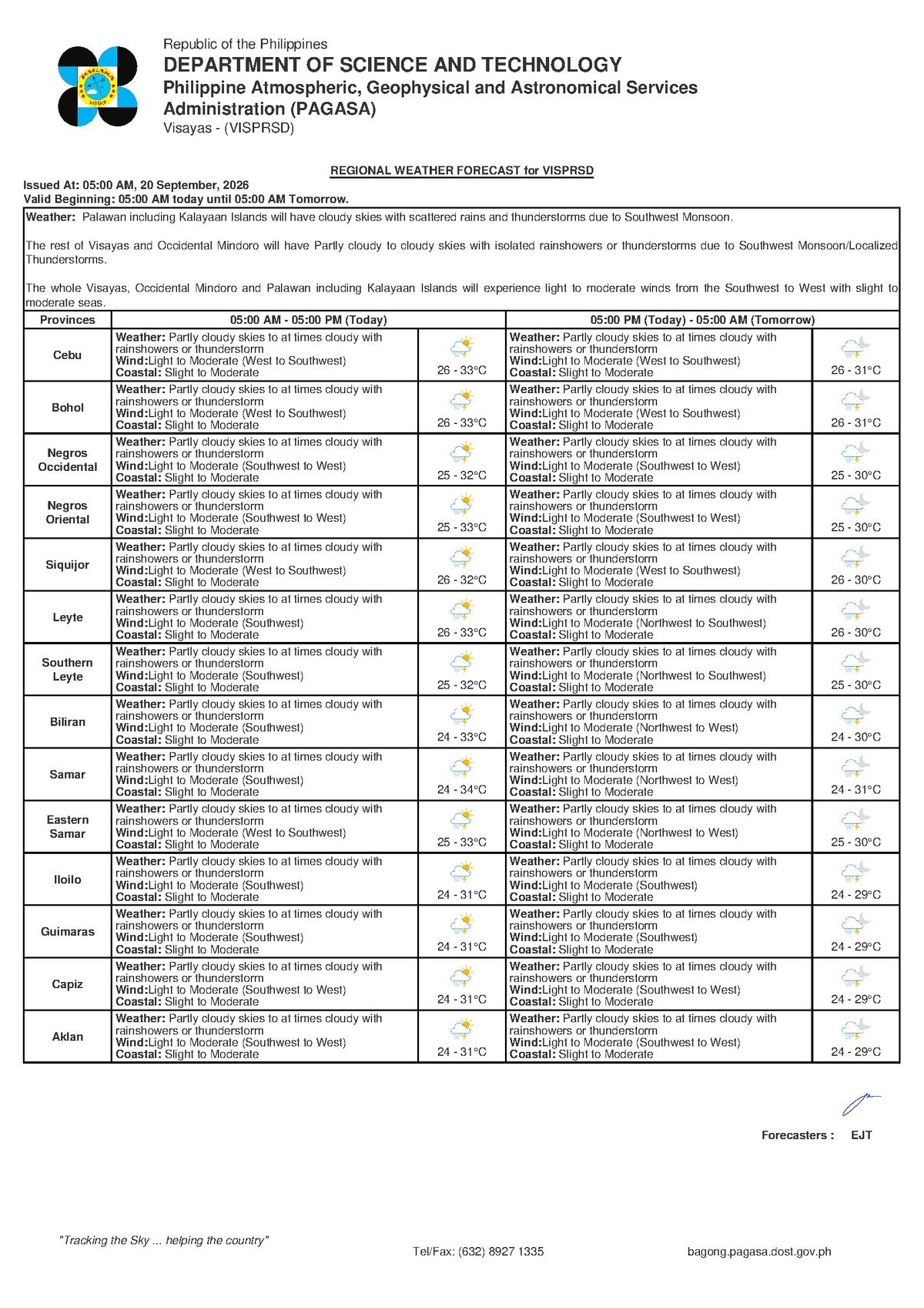
PAGASA’s Visayas Regional Forecast, issued at 5:00 AM on September 20, 2026, describes skies across the region as partly cloudy to at times cloudy throughout the day, with rainshowers or thunderstorms expected to develop. The agency placed the temperature range for the Visayas region between 26°C on the cooler end and 33°C at the warmest, reflecting the humid, tropical conditions typical of a Philippine September.
Winds are reported blowing from the west to southwest direction at light to moderate speeds. PAGASA noted that no active rainfall warnings — whether yellow, orange, or red — are in effect for the region, and no tropical cyclone wind signals have been raised. The weather pattern is characterized as within the normal range of rainy-season conditions, but forecasters note that thunderstorms should never be dismissed lightly.
By the Numbers
- Forecast release time: 5:00 AM, September 20, 2026
- Temperature range across the Visayas: 26°C (low) to 33°C (high)
- Wind direction: west to southwest at light to moderate speed
- Coastal sea state: slight to moderate condition
- Rainfall warning levels in effect: zero (none raised)
- Tropical cyclone wind signals in effect: zero (none raised)
What Is Powering the Rain
The weather driver behind today’s showers is the habagat, or southwest monsoon — the dominant seasonal wind system across the Philippine archipelago from June through September. According to PAGASA’s forecast data, the habagat pulls warm, moisture-heavy air in from the West Philippine Sea and the broader southwestern ocean. As this air mass moves inland and encounters the heated land surface during the midday hours, it rises rapidly, cools, and releases its moisture as afternoon rainshowers and thunderstorms.
This process — called convective weather development — is the standard mechanism behind September rains in Negros Oriental and the wider Visayas. It is not a sign of an approaching typhoon or severe disturbance. Nevertheless, the resulting thunderstorms can be sudden, intense, and dangerous if precautions are not observed.
Province-by-Province Outlook
In Dumaguete City, the provincial capital of Negros Oriental, mornings may begin with relatively tolerable skies before clouds thicken through midday. Showers and possible thunderstorms are most probable during the afternoon and early evening hours, consistent with habagat-driven convective patterns in September.
Residents in Bayawan City and Bais City in the southern portion of the province, as well as Guihulngan City in the north, should expect the same partly cloudy to cloudy conditions with periodic rain and thunderstorm risk throughout the day, according to the regional forecast.
On the island of Siquijor, located just off Negros Oriental’s southeastern coast, PAGASA’s forecast likewise calls for partly cloudy to cloudy skies with rainshowers or thunderstorms. Visitors and residents planning outdoor activities on the island should be prepared for the day to turn wet at any point.
Across Cebu and the remaining Visayas provinces, conditions mirror those described above — the same temperature band, wind pattern, and precipitation probability apply region-wide, making this a broad weather pattern rather than a localized event.
What the Forecast Language Really Means
PAGASA’s phrasing of “partly cloudy to at times cloudy with rainshowers or thunderstorm” carries specific practical meaning worth unpacking:
Partly cloudy to at times cloudy: Expect the sky to evolve during the day. Clear or hazy sunshine may greet the early morning, but cloud cover will thicken progressively through midday and into the afternoon.
Rainshowers: These are rain events that can begin and end relatively quickly but may be intense while active. In low-lying portions of Dumaguete, Bais, and other coastal communities, brief but heavy showers can cause localized flooding in flood-prone streets and drainage channels.
Thunderstorm: This is the most serious element in today’s forecast. PAGASA’s thunderstorm advisory implies the possibility of lightning, sudden strong and gusty winds, and concentrated heavy rainfall over a short duration. Lightning remains one of the foremost causes of weather-related fatalities in the Philippines. Anyone who hears thunder should move indoors immediately, staying away from trees, open fields, elevated ridges, and bodies of water until the storm passes.
Coastal Waters and Ferry Travel
PAGASA describes coastal waters across the Visayas as being in slight to moderate condition today, driven by the westerly to southwesterly winds at light to moderate speeds. The agency has not raised any gale warning for Visayas sea lanes as of the 5:00 AM forecast issuance.
For passengers booked on ferry or fast-craft routes — such as those connecting Dumaguete to Cebu, Siquijor, or other inter-island ports — slight to moderate seas mean noticeable swelling and vessel movement, particularly aboard smaller craft. Individuals prone to seasickness are advised to take appropriate medication before boarding. More critically, sea conditions can deteriorate rapidly should a thunderstorm develop directly over or near active sea lanes. Passengers are strongly encouraged to confirm departure status directly with their ferry operator before heading to the port.
Fisherfolk and small-boat operators face additional risk. While slight to moderate seas fall within the general operating range for small to medium fishing vessels, the afternoon thunderstorm threat means conditions at sea can shift dramatically within minutes. PAGASA data and maritime safety advisories consistently recommend that small outrigger bancas — whether motorized or paddle-driven — avoid late afternoon departures during thunderstorm-prone days. Fisherfolk should watch the horizon for darkening cumulonimbus cloud formations and return to port well ahead of any approaching storm.
Guidance for Key Groups
Farmers Across the Province
Agricultural workers — including those managing sugarcane fields in the central plains of Negros Oriental, rice paddies near Bais and Manjuyod, and vegetable plots in upland barangays — face a mixed picture today. The forecast rainshowers will provide natural irrigation benefit, potentially reducing the need for manual watering. However, concentrated or prolonged thunderstorm activity carries the risk of localized flooding in low-elevation farm areas and wind damage to standing crops. The practical advice is to schedule field work during the morning hours when skies are more likely to remain manageable, and to secure loose equipment, harvested produce, and other farm materials before afternoon showers develop.
Students, Families, and Weekend Gatherings
For families with children engaged in Sunday activities, church services, sports events, or community gatherings, the primary concern is the afternoon thunderstorm window. Outdoor afternoon programs should have contingency plans for moving indoors. Everyone traveling by foot or motorcycle should carry an umbrella or rain jacket as a minimum precaution.
Commuters and Motorcycle Riders
Urban roads in Dumaguete and other municipal centers across Negros Oriental become hazardous quickly during heavy downpours. Motorcycle riders — who represent a large segment of daily commuters throughout the province — should reduce speed, increase following distance, and avoid waterlogged stretches of road. Riding through flooded sections, even shallow ones, risks engine damage and loss of vehicle control. When heavy rain begins, pulling over to a safe covered area and waiting for the shower to ease is strongly recommended.
Why This Matters
The southwest monsoon’s continued influence through late September sustains weeks of recurring afternoon thunderstorm risk across Negros Oriental and the Visayas — a pattern that cumulatively affects agricultural output, inter-island transport schedules, and daily public safety, particularly for outdoor workers and coastal communities. PAGASA’s accurate and timely dissemination of forecast data, even for non-emergency weather days like this one, gives residents, farmers, and maritime operators the information needed to make practical, potentially life-saving decisions. Lightning fatalities, flash flooding in urban drains, and maritime incidents during sudden thunderstorms are real and documented hazards associated with exactly this type of forecast — making public awareness of even routine advisories genuinely consequential.
Source: Breaking News Negros Oriental (breakingnewsnegrosoriental.com), based on PAGASA Visayas Regional Forecast issued September 20, 2026.