Changeable skies and afternoon downpours are in store for Negros Oriental this Tuesday, June 2, 2026, as the Philippine Atmospheric, Geophysical and Astronomical Services Administration (PAGASA) places the province and the broader Visayas region under a wet weather forecast. The agency released its regional weather advisory at 5:00 AM, citing prevailing southwest to south winds as the primary driver — a clear sign that the habagat, or southwest monsoon season, is tightening its grip over the central Philippines.
Tuesday’s Weather Pattern at a Glance
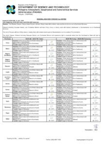
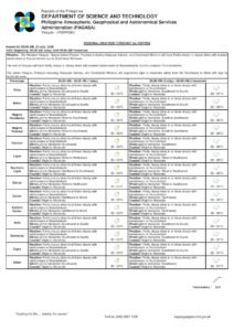
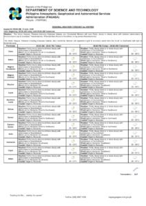
According to PAGASA, skies over Negros Oriental will shift between partly cloudy and overcast throughout the day, with rainshowers and thunderstorms developing at various intervals. Afternoon hours are of particular concern, as convective activity tends to intensify during peak heating periods — especially over the province’s interior highlands and elevated barangays.
Temperature readings are expected to swing from a nighttime low of 27°C to an afternoon high of 34°C. PAGASA cautions that relatively clear morning skies should not be taken as a sign of a fair day — conditions can deteriorate rapidly as the sun heats the land surface and moisture-laden winds push in from the southwest.
Wind speeds will remain light to moderate, blowing from the southwest to the south — a pattern consistent with the onset of the habagat. This seasonal shift typically brings wetter and cloudier conditions to the Visayas compared to the drier months dominated by the northeast monsoon, or amihan.
Coastal Advisory: Guidance for Seafarers and Ferry Passengers
Coastal waters surrounding Negros Oriental are under a slight to moderate sea state, PAGASA reported. Wave heights are expected to remain manageable for larger inter-island vessels under normal circumstances. However, passengers travelling on routes connecting Dumaguete to Siquijor, Dumaguete to Cebu, and Bayawan to other Visayas ports are advised to coordinate with their respective ferry operators — including OceanJet and other inter-island carriers — regarding any schedule modifications or cancellations.
PAGASA warned that sea conditions can deteriorate without much warning when active thunderstorm cells move through the area. Operators may impose precautionary measures during such episodes. Small fishing boats and bancas navigating the Tanon Strait and adjacent coastal waters should exercise heightened caution, as even light to moderate winds combined with squall-driven waves can create hazardous patches at sea.
How Conditions Break Down by Area
The PAGASA Visayas regional forecast applies across the full breadth of Negros Oriental — from coastal lowlands to mountainous interiors. Here is how the weather is expected to play out in key areas of the province:
Dumaguete City, the provincial capital, will experience the same mix of partly cloudy skies punctuated by rain bursts and thunderstorms. Those with outdoor events or activities lined up for the afternoon are strongly advised to prepare backup arrangements.
Bayawan City and Bais City, situated along the western and central coastlines respectively, face comparable conditions. Agricultural workers — particularly those tending to sugarcane fields and vegetable plots — should watch for sudden heavy rain episodes that may disrupt field operations or cause waterlogging in low-lying plots.
Guihulngan City and surrounding upland communities in the northern part of Negros Oriental are at heightened risk of localized intense rainfall, as PAGASA notes that thunderstorms frequently gain strength over elevated and mountainous terrain. Residents in hilly barangays should remain on alert.
Siquijor, the island province lying just southeast of Negros Oriental, falls within the same Visayas regional forecast area. Both island residents and tourists should brace for intermittent rainfall throughout the day. Anyone planning boat crossings to or from Siquijor is advised to verify current sea conditions with ferry operators before setting out.
Three-Day Extended Outlook: No Relief in Sight
PAGASA’s extended weather outlook, released at 9:00 AM on Sunday, June 1, 2026, projects a continuation of the same unsettled pattern through at least midweek. The agency outlined the following forecast windows:
- Monday, June 1: Temperatures ranging from 28°C to 33°C — light to moderate southwest to south winds — slight to moderate coastal sea state
- Tuesday, June 2: Temperatures ranging from 28°C to 34°C — light to moderate southwest to south winds — slight to moderate coastal sea state
- Wednesday, June 3: Temperatures ranging from 28°C to 34°C — light to moderate southwest to south winds — similar coastal conditions expected to persist
This three-day pattern, according to PAGASA, reflects sustained southwest monsoon influence over the Visayas with no significant shift toward fair weather expected within the near-term outlook period. The gradual creep of daytime highs toward 34°C alongside recurring afternoon thunderstorms is a defining characteristic of the Philippine wet season transition, the agency noted.
Farmers and Fisherfolk: Practical Guidance
The agricultural heartlands of Negros Oriental — spanning sugarcane-producing lowlands and vegetable farms in the cooler uplands — face a mixed picture from this weather setup. On one hand, rainfall from monsoon-influenced showers provides welcome soil moisture for crops during a warm period. On the other hand, PAGASA warns that intense rain bursts linked to thunderstorms can trigger localized flooding and inflict damage on crops, particularly in poorly drained, low-elevation fields.
For fisherfolk operating out of Dumaguete, Tambobo Bay, and other coastal landing sites, PAGASA recommends scheduling sea activities during the early morning hours when winds and seas are typically at their calmest, and heading back to shore well before afternoon thunderstorm activity reaches its peak. The agency advises continuous monitoring of weather developments throughout the day.
Safety Measures During Thunderstorm Conditions
PAGASA and disaster risk reduction authorities consistently issue the following safety advisories when thunderstorms are in the forecast:
Remain indoors or move to a sturdy structure once lightning activity and heavy rainfall begin. Avoid open areas, lone trees, and elevated hilltops during active thunderstorm episodes. Unplug sensitive electrical appliances and devices during lightning to minimize the risk of surge damage. Refrain from wading through or driving across flooded roads, as the true depth and current force of floodwaters are often deceptive. Keep mobile phones charged and monitor local radio broadcasts for the latest updates.
Residents living in low-lying barangays beside rivers or drainage channels are urged to stay alert to the risk of localized flash flooding, particularly if storm cells move slowly or stall over the same area for an extended period.
About This Forecast
This weather report draws from PAGASA’s Visayas Regional Weather Forecast issued at 5:00 AM on Tuesday, June 2, 2026, as well as the agency’s Extended Weather Outlook released at 9:00 AM on June 1, 2026. As PAGASA notes, all forecasts are subject to revision as updated meteorological data becomes available, and conditions may differ considerably between coastal and interior zones or between morning and afternoon time windows.
For the latest official updates, visit PAGASA at pagasa.dost.gov.ph. Visayas-specific regional advisories can be accessed through the PAGASA Visayas regional forecast portal.
Source: breakingnewsnegrosoriental.com / PAGASA Visayas Regional Weather Forecast