Overcast skies, afternoon downpours, and the rumble of distant thunder are in store for Negros Oriental and much of the Visayas today, June 5, 2026, as the Philippine Atmospheric, Geophysical and Astronomical Services Administration (PAGASA) released its regional forecast at 5:00 AM, flagging the likelihood of rainshowers and thunderstorms throughout the day. Residents, commuters, fisherfolk, and ferry passengers are all being urged to exercise caution and prepare for rapidly changing conditions.
General Weather Conditions for Negros Oriental
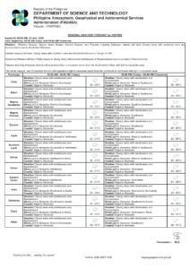
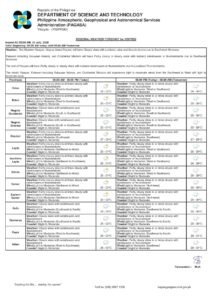
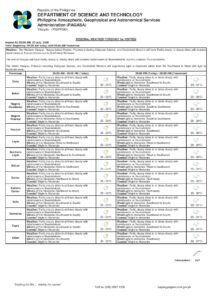
According to PAGASA’s 5:00 AM bulletin, skies over the province will be partly cloudy to overcast, with rainshowers or thunderstorms possible at various points during the day. The weather pattern is consistent with what communities across Negros Oriental typically experience as the wet season takes hold in early June.
Major urban and rural areas — including Dumaguete City, Bayawan, Bais, Guihulngan, and Canlaon — can expect intermittent bouts of rain. Residents heading out are strongly advised to carry rain gear, and those in open-air environments should pay close attention to changes in sky conditions, particularly as the afternoon progresses.
Temperatures will hover between a low of 26°C and a high of 33°C, according to PAGASA. The warm, moisture-saturated air in the lower atmosphere creates ideal conditions for afternoon convective storms — those quick-building, intense episodes of heavy rainfall, lightning, and gusty winds that can arrive with little warning, especially between early afternoon and early evening hours.
Winds are blowing from the southwest to southeast at light to moderate speeds. This orientation reflects the gradual strengthening of the southwest monsoon, or habagat, which PAGASA notes is beginning to exert its influence across the Visayas in this period.
Sea Travel Advisory for Coastal Communities
PAGASA has classified coastal waters across the Visayas as slight to moderate for Friday. While conditions are generally navigable for larger inter-island vessels, small boats and motorized bancas may face difficulties, especially during active thunderstorm periods when wave heights can spike suddenly and visibility at sea drops sharply.
Passengers booked on ferry routes connecting Dumaguete to Siquijor, Cebu, or Bohol — including services operated by OceanJet and Montenegro Lines — should verify departure status with their respective shipping lines and check for any advisories from the Philippine Coast Guard before heading to the pier. Even under manageable baseline sea conditions, localized squalls can develop quickly along these routes.
Fisherfolk from coastal municipalities such as Bayawan, Zamboanguita, Dauin, and Siaton are encouraged to remain vigilant while at sea and to return to port ahead of any visible weather deterioration. PAGASA consistently advises small vessel operators not to wait until storms are directly overhead before heading back to shore.
Conditions in Siquijor and the Broader Visayas
The island province of Siquijor falls under the same regional forecast, with PAGASA projecting partly cloudy to cloudy skies accompanied by rainshowers or thunderstorms, temperatures between 26°C and 33°C, and slight to moderate seas around the island. Tourists visiting sites like Cambugahay Falls or Paliton Beach should plan outdoor excursions during the morning, when skies tend to be more cooperative, and remain alert to the onset of afternoon storms.
The rest of the Visayas — including Cebu, Bohol, Leyte, and Samar — faces broadly similar conditions, with PAGASA noting consistent patterns of intermittent rainshowers, thunderstorms, light to moderate southwesterly winds, and slight to moderate coastal waters region-wide.
Extended Forecast: Wet Weather Pattern to Persist Through the Weekend
PAGASA’s extended weather outlook, issued at 9:00 AM on June 4, 2026, projects that this unsettled weather pattern will continue through at least the next several days. Temperatures are expected to remain between 27°C and 33°C into the following week, with light to moderate winds shifting among south, southwest, and southeast directions, and coastal conditions staying in the slight to moderate range.
The sustained nature of this forecast is consistent with a region either entering or already in the grip of the southwest monsoon. Once habagat becomes the dominant weather driver, afternoon thunderstorms across the Visayas become a near-daily occurrence. PAGASA advises the public to treat this pattern as routine for the coming weeks and to build weather awareness into daily planning.
Guidance for Farmers Across the Province
For the agricultural communities of Negros Oriental, the seasonal rains are a double-edged development. Sugarcane and rice farmers in the lowland areas between Bais and Manjuyod, vegetable growers in the upland communities of Valencia and Sibulan, and corn farmers scattered across the province will benefit from natural irrigation — but also face heightened risks from waterlogging, flooding, and lightning exposure in the field.
Farm operators are encouraged to inspect drainage channels to prevent standing water in low-lying plots, particularly after sustained or heavy rainfall episodes. Crops that are close to harvest should ideally be collected during the drier morning windows rather than during late-afternoon hours when the risk of intense thunderstorms peaks.
Lightning safety remains a serious concern for outdoor agricultural workers. PAGASA and safety experts consistently advise that workers abandon open fields at the first sound of thunder or sight of lightning, seeking shelter inside sturdy structures rather than under isolated trees, which are frequent lightning strike points.
Public Safety Reminders During Thunderstorm Season
The Provincial Disaster Risk Reduction and Management Office (PDRRMO) of Negros Oriental, alongside PAGASA, regularly issues the following reminders during bouts of heavy rain and thunderstorms:
Stay indoors or inside a solid structure when thunder is audible. Avoid walking or driving through flooded roadways, as standing floodwaters may hide open manholes, submerged debris, or live electrical hazards. Disconnect sensitive electronics and appliances during active lightning storms. Drivers should reduce speed and keep headlights on during heavy downpours. School administrators and parents are urged to monitor morning weather conditions before committing to outdoor activities or events.
Residents living near rivers, creeks, or low-lying coastal stretches should remain on alert for rapid water level rises during periods of prolonged or intense rainfall. For emergencies or flood-related incidents, the public may contact their barangay’s Disaster Risk Reduction and Management Council (BDRRMC) or the Negros Oriental PDRRMO directly.
How to Stay Updated
“Partly cloudy skies to at times cloudy with rainshowers or thunderstorm. Temperature: 26°C to 33°C. Wind Speed: Light to Moderate. Direction: Southwest to Southeast. Coastal Condition: Slight to Moderate.” — PAGASA Visayas Regional Forecast, 5:00 AM, June 5, 2026
Weather conditions during thunderstorm season can shift rapidly within short time spans. BNNO will continue tracking developments across the province and the Visayas region and will publish updates as new PAGASA bulletins become available. Readers are strongly encouraged not to rely solely on morning forecasts but to check back throughout the day as conditions evolve.
For the latest official weather data, visit PAGASA’s website at pagasa.dost.gov.ph or follow its official social media channels for real-time bulletins and storm advisories.
Source: Breaking News Negros Oriental (breakingnewsnegrosoriental.com)