DUMAGUETE CITY, Negros Oriental — October 1, 2026 — The Philippine Atmospheric, Geophysical and Astronomical Services Administration (PAGASA) has placed the Visayas region, including all of Negros Oriental, under a forecast of rainshowers and thunderstorms for Thursday, cautioning residents from Dumaguete to Guihulngan — and across the strait to Siquijor — to prepare for an unsettled and wet day ahead.
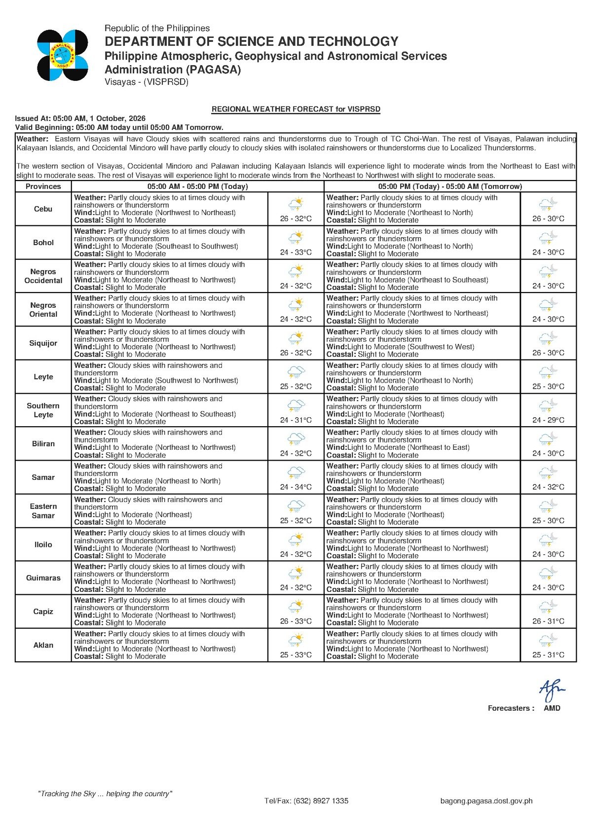
The warning was contained in PAGASA’s regional weather bulletin released at 5:00 AM on October 1, 2026, painting a picture of partly cloudy to periodically overcast skies punctuated by sudden, sometimes heavy downpours that can occur at any hour of the day or night.
No Named Weather System Identified
Notably, the PAGASA forecast for October 1 does not attribute Thursday’s wet conditions to any specific named weather system. No tropical cyclone, low-pressure area, northeast monsoon (amihan), or southwest monsoon (habagat) is cited as the driver of the rain and cloudiness in the bulletin reviewed for this report.
What PAGASA does confirm is that the Visayas region is experiencing partly cloudy to cloudy skies with embedded showers and thunderstorm activity — a weather pattern broadly consistent with October’s transitional character in the Philippines, as the country shifts from the wet season toward the cooler, drier months of the year. Residents are advised to follow PAGASA’s official bulletins throughout the day for any updates or system identification as conditions evolve.
By the Numbers
- 5:00 AM, October 1, 2026 — Time of PAGASA’s main regional forecast bulletin
- 9:00 AM, September 30, 2026 — Time of PAGASA’s extended outlook bulletin issued the previous day
- 26°C — Forecast low temperature for the Visayas on Thursday
- 32°C — Forecast high temperature for Thursday
- 33°C — Projected high temperature rising by Friday
- Slight to moderate — Classified coastal sea conditions for Thursday
- Light to moderate — Forecast wind strength, blowing northwest to northeast
Full Forecast Breakdown for Thursday
According to the PAGASA regional bulletin issued at 5:00 AM on October 1, 2026, the following conditions are expected across the Visayas for Thursday:
- Sky and precipitation: Partly cloudy intervals, with periods of cloudiness, rainshowers, and embedded thunderstorms possible at any time of day.
- Temperature range: Low of 26°C to a high of 32°C. Cooler readings are expected during and after rainfall episodes; warmer readings during any brief sunny intervals.
- Wind direction and speed: Light to moderate, blowing from the northwest to northeast.
- Coastal and sea conditions: Slight to moderate seas.
A separate extended weather outlook issued by PAGASA at 9:00 AM on Wednesday, September 30, 2026 — looking ahead to Thursday and beyond — aligns with the main bulletin: light to moderate northeast to north winds, slight to moderate coastal sea states, and the same temperature band of 26°C to 32°C for Thursday, with the high climbing to 33°C by Friday.
What “Slight to Moderate” Seas Mean for Maritime Travel
PAGASA’s classification of coastal waters as “slight to moderate” carries specific practical implications for those who depend on the sea — whether for livelihood or transportation.
For larger passenger ferry operators — including vessels on the Dumaguete–Cebu, Dumaguete–Dapitan, and Dumaguete–Siquijor routes — slight to moderate conditions are generally within operational limits. However, PAGASA advises that localized squalls and reduced visibility during thunderstorm episodes can still disrupt schedules. Passengers are strongly urged to arrive at the port early, confirm departure status directly with their ferry operator, and monitor updated PAGASA marine advisories before boarding.
For small outrigger boat (banca) operators — particularly fisherfolk from coastal communities in Bayawan, Siaton, Zamboanguita, and the barangays ringing Dumaguete — the combination of slight to moderate seas and possible thunderstorms demands heightened caution. PAGASA warns that sea conditions can escalate quickly when a thunderstorm passes through. Fisherfolk are advised to stay within sight of shore and to return immediately if a storm system is approaching — without waiting for it to arrive overhead.
The Dumaguete–Siquijor crossing, though short, is an exposed stretch of open water where even slight to moderate seas can feel noticeably choppy. PAGASA recommends that passengers susceptible to seasickness prepare accordingly and that those with schedule flexibility monitor actual morning conditions before committing to the crossing.
Activity-by-Activity Guidance
Commuters and Road Travelers
Those moving between Dumaguete and outlying municipalities — including Bayawan, Bais, and Guihulngan along the national highway corridor — should anticipate wet road surfaces at various points during Thursday. Thunderstorm-embedded rain can arrive suddenly and intensify quickly. Motorcycle riders are advised to reduce speed on slick pavement. Drivers should use headlights during downpours and allow extra travel time. Rain gear should be kept accessible at all times.
Fishing Communities and Small-Boat Operators
Experienced fisherfolk aboard larger, sturdier vessels may find the light to moderate winds and slight to moderate seas manageable. Those operating small bancas, however, should approach Thursday with extra caution. Thunderstorms along coastal waters and open sea can strike with little advance warning, according to PAGASA. The agency strongly urges fisherfolk to stay close to shore as conditions deteriorate and to monitor weather radio updates or official PAGASA advisories before departure. If lightning becomes visible or thunder audible, remaining on shore is the safest course of action.
Farmers Across Negros Oriental
Agricultural workers in the sugarcane-growing lowlands near Bais, as well as vegetable farmers in the upland barangays of Valencia, Sibulan, and the mountain municipalities of Negros Oriental, should plan for rain interruptions that may delay fieldwork and harvesting throughout Thursday. Intermittent rainfall can benefit crops, but PAGASA’s forecast of possible thunderstorms means that pesticide and fertilizer applications should be deferred until a confirmed dry window — rain will reduce the effectiveness of chemical treatments by washing them away. Harvested produce and farm equipment should be secured ahead of any storm activity.
Parents, Students, and Schools
PAGASA’s October 1 bulletin does not include any active weather signal warnings that would automatically trigger class suspensions under the current national protocol. Nonetheless, thunderstorms are possible throughout school hours. Parents are encouraged to send children to school equipped with umbrellas or raincoats and to monitor announcements from their local government unit, as mayors and city officials retain authority to suspend classes based on actual ground conditions. Students in flood-prone, low-lying barangays should exercise particular care when walking to and from school.
Outdoor and Construction Workers
Workers in construction, road repair, and other outdoor industries across Negros Oriental should build rain interruptions into their Thursday work schedules. When thunderstorms occur, PAGASA notes, they can produce strong wind gusts and lightning — serious hazards for personnel working at elevation or near metal structures and equipment. Supervisors are advised to implement a clear inclement-weather protocol that includes a designated shelter area and a defined procedure for halting work when lightning is observed.
Tourists and Outdoor Event Organizers
Visitors to Negros Oriental’s beaches, dive sites, waterfalls, and other outdoor attractions should plan for the possibility of rain at any point during Thursday. While conditions are not forecast to be catastrophic, thunderstorms can disrupt outdoor excursions and diving activities. Organizers of events scheduled for Thursday are advised to prepare contingency arrangements and to check for PAGASA updates throughout the morning before making go or no-go decisions.
Why This Matters
A forecast of rainshowers and thunderstorms across Negros Oriental and the broader Visayas affects a wide range of daily activities — from maritime livelihoods and agricultural work to school attendance and inter-island travel — making timely awareness of PAGASA’s bulletin practically important for residents across the province. The classification of coastal waters as “slight to moderate” is particularly significant for the fishing communities and ferry passengers who depend on sea crossings daily, as embedded thunderstorms can cause rapid deterioration of conditions beyond what the baseline forecast might suggest. Residents are reminded that PAGASA will issue updated bulletins throughout the day, and that local government units have the authority and responsibility to respond to evolving conditions on the ground.
Source: Breaking News Negros Oriental (breakingnewsnegrosoriental.com)