DUMAGUETE CITY, Negros Oriental — A wet and unsettled Wednesday is in store for Negros Oriental and the broader Visayas region, with the Philippine Atmospheric, Geophysical and Astronomical Services Administration (PAGASA) warning that rainshowers and thunderstorms could break out at any time on September 30, 2026. From coastal communities along Dumaguete’s shoreline to farming villages in the uplands of Guihulngan, residents are urged to take precautions, keep rain gear on hand, and stay alert to rapidly shifting conditions throughout the day.
The Official Forecast
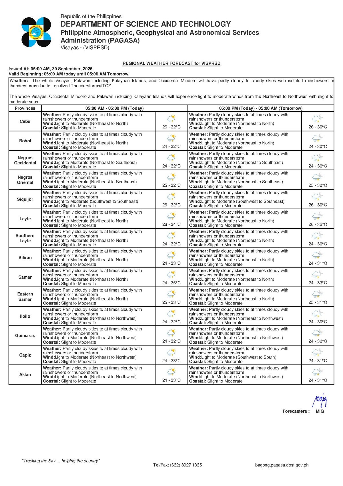
PAGASA released its Regional Weather Forecast for the Visayas at 5:00 AM on Wednesday, September 30, 2026. A separate Extended Weather Outlook covering a broader multi-day period was also published on September 28, 2026 at 9:00 AM, according to the state weather bureau’s bulletin.
The forecast issued by PAGASA indicates that the Visayas — encompassing Negros Oriental, Siquijor, Cebu, and surrounding island provinces — will see partly cloudy to at times cloudy skies throughout Wednesday. Rainshowers and thunderstorms are expected to develop at various points during the day, with conditions capable of shifting from brief sunny spells to sudden downpours within minutes.
PAGASA’s temperature forecast for most of Negros Oriental places the overnight low at 26 degrees Celsius, with the daytime high reaching 32 degrees Celsius during the warmest hours of the afternoon. While these figures fall within a typical range for the province in late September, the combined effect of humidity, intermittent cloud cover, and passing showers may cause temperatures to feel alternately warmer when skies briefly clear and cooler when rain arrives.
Surface winds, according to PAGASA’s bulletin, are blowing from the northeast to north at light to moderate speeds.
What Is Behind Wednesday’s Weather
The PAGASA bulletin for Wednesday does not explicitly identify a single dominant weather system as the cause of the unsettled conditions over the Visayas. The combination of northeast to north wind direction, partly cloudy skies, and scattered rainshowers or thunderstorms is, however, consistent with transitional weather patterns typical of late September — a period when the region shifts between the waning southwest monsoon season and the approaching northeast monsoon. As PAGASA has not named a specific driver in its issued forecast bulletin, no further speculation will be made here. Residents are encouraged to visit pagasa.dost.gov.ph directly for any updated system advisories or supplemental bulletins issued during the day.
Coastal and Sea Conditions
For the coastal waters surrounding Negros Oriental and the wider Visayas, PAGASA has assessed sea conditions as slight to moderate on Wednesday. In practical terms, this spans a wave height range of approximately 0.5 to 2.5 meters, meaning conditions can vary significantly by location and time of day.
Slight seas — generally wave heights of around 0.5 to 1.25 meters — are manageable for most vessels under normal circumstances. Moderate seas, with wave heights of roughly 1.25 to 2.5 meters, can be handled by larger passenger ferries and cargo vessels but may pose serious risks for small fishing bancas and outrigger boats. PAGASA’s bulletin notes no active Gale Warning for the Visayas at this time, and no Tropical Cyclone Wind Signal has been issued for Negros Oriental or any neighboring province based on available data.
That said, sea conditions can deteriorate rapidly when thunderstorms pass over open water, even when the overall coastal rating appears moderate. Residents and operators near the shoreline should not treat the absence of a Gale Warning as a guarantee of safe conditions throughout the entire day.
Advice for Ferry Passengers and Inter-Island Travelers
Those planning to travel by sea between Dumaguete and Siquijor, Cebu, or other Visayas ports via operators such as OceanJet, Montenegro Lines, or other inter-island ferry services should factor in both the slight to moderate coastal seas and the possibility of thunderstorm development when planning their trips on Wednesday.
While PAGASA has not issued a Gale Warning based on the current forecast data, travelers are advised to confirm departure schedules and route-specific advisories directly with their ferry operators before heading to the port. Building extra time into travel plans is wise given the potential for weather-related delays. Passengers should also avoid booking passage on small, open motorized bancas if thunderstorms are visibly forming along the planned route. The Bohol Strait, Tañon Strait, and Siquijor Channel — the primary water routes for inter-island travel from Negros Oriental — can turn from manageable to rough in a very short window once a storm system develops nearby.
Guidance for Fisherfolk and Small Boat Operators
Fisherfolk working off the coastlines of Bayawan, Bais, Tanjay, Siaton, Dauin, and Siquijor should exercise heightened caution on Wednesday. The slight to moderate coastal rating, paired with the risk of isolated thunderstorms, can turn a routine fishing run into a dangerous situation if a squall develops in the area.
According to PAGASA’s forecast, rainshowers and thunderstorms — including fast-moving squalls — are possible during the day. Squalls can generate sudden strong gusts, dramatically reduce visibility at sea, and create locally choppy to rough conditions even when the broader forecast appears moderate. The state weather bureau’s data suggests fisherfolk should prioritize early-morning trips when skies may still be relatively clear, and return to shore well before midday when convective storm activity — driven by daytime heating — is at its peak. Close observation of cloud formations is essential: rapidly building dark thunderheads are a clear signal to head back immediately. Overnight trips to deeper waters are best avoided unless conducted aboard larger, fully equipped vessels.
Guidance for Farmers Across the Province
Agricultural communities in rice-growing areas such as Manjuyod, La Libertad, Tayasan, and Jimalalud, as well as sugarcane and vegetable growers throughout Negros Oriental, should plan their field activities around Wednesday’s scattered shower pattern.
The interplay between a 32°C daytime high and intermittent afternoon rains may cause soil moisture levels to fluctuate through the day. While rain can reduce the need for supplemental irrigation, sudden heavy downpours during harvesting or planting operations risk disrupting work schedules and potentially damaging freshly cut crops left exposed in open fields. PAGASA’s forecast suggests prioritizing harvesting activities during early morning hours before thunderstorms are most likely to build. Harvested grains and produce should be moved under cover before noon, and drainage in low-lying farm plots should be inspected ahead of any localized heavy rainfall associated with thunderstorm activity.
For Students, Parents, and Schools
Parents sending children to school in Dumaguete City and across Negros Oriental on Wednesday should make sure raincoats or umbrellas are packed. Based on the current PAGASA bulletin, the weather conditions described — partly cloudy skies with intermittent rainshowers — do not constitute grounds for a class suspension. There is no indication of continuous or catastrophic rainfall that would typically trigger such a measure. However, parents are advised to monitor their school’s official communication channels throughout the day, as local government units may issue updates if conditions deteriorate more sharply than expected.
For Outdoor Workers and Residents on the Move
Construction workers, market vendors, public transport drivers, and any resident whose daily work takes place outdoors should build a rain contingency into their Wednesday schedule. According to PAGASA’s assessment, showers or thunderstorms could develop at virtually any point during the day, making it impractical to rely on a fixed “safe window” for outdoor activities. Carrying rain protection at all times and staying alert to changes in sky conditions remains the most practical advice. Residents are encouraged to follow PAGASA’s official social media accounts and website for any updated advisories issued as Wednesday progresses.
By the Numbers
- 5:00 AM, September 30, 2026 — time PAGASA issued its Regional Forecast for the Visayas
- 9:00 AM, September 28, 2026 — time PAGASA issued its Extended Weather Outlook
- 26°C — overnight low temperature forecast for most of Negros Oriental
- 32°C — daytime high temperature forecast for most of Negros Oriental
- 0.5 to 1.25 meters — wave height range for slight sea conditions
- 1.25 to 2.5 meters — wave height range for moderate sea conditions
Why This Matters
Wednesday’s forecast of scattered rainshowers and thunderstorms across the Visayas carries real consequences for multiple sectors in Negros Oriental — from fisherfolk navigating slight to moderate coastal seas to farmers protecting crops from sudden downpours and ferry passengers managing travel uncertainty. While no Gale Warning or Tropical Cyclone Wind Signal has been issued by PAGASA, the unpredictable nature of convective thunderstorms means conditions on land and at sea can deteriorate rapidly with little advance warning. Staying informed through official PAGASA advisories and taking early precautionary steps remains the most effective way for residents to protect their safety and livelihoods on a day characterized by transitional and unsettled weather.
Source: Breaking News Negros Oriental (breakingnewsnegrosoriental.com)