Moisture-laden winds from the southwest monsoon, known locally as the habagat, are pushing heavy rainfall and rough seas across much of Luzon on Thursday, June 4, 2026 — prompting the Philippine Atmospheric, Geophysical and Astronomical Services Administration (PAGASA) to raise flash flood and landslide alerts for several regions. The 24-hour forecast, released by PAGASA at 4:00 AM and valid until 4:00 AM on June 5, 2026, urges vigilance among residents living in low-lying, flood-prone, and mountainous areas.
Although the southwest monsoon’s strongest effects are concentrated over Luzon’s northern and central sections, weather disturbances are not limited to that island group. The Visayas and Mindanao face their own hazards from localized convective thunderstorms, which can bring intense, sudden rainfall even when the broader weather picture appears calmer.
Monsoon Impact Across Luzon’s Regions
The habagat is the dominant weather force shaping conditions across Luzon on Thursday. Its influence varies in intensity depending on location, but hazardous weather is a concern from the northernmost tip of the island group to its southern reaches.
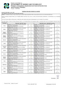
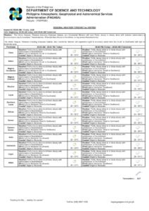
Ilocos Region, Zambales, Bataan, Tarlac, and Pampanga
The areas most directly in the monsoon’s path include the entire Ilocos Region and the western Central Luzon provinces of Zambales, Bataan, Tarlac, and Pampanga. PAGASA forecasts occasional rainfall for these provinces, with the possibility of moderate to heavy downpours that could trigger flash flooding along riverbanks and drainage channels, as well as landslides on unstable slopes. The weather agency advises residents in these localities to steer clear of flood-prone zones and remain on alert throughout the day.
Metro Manila, Cagayan Valley, CAR, CALABARZON, MIMAROPA, and Remaining Central Luzon Provinces
A wider band of Luzon — stretching from the National Capital Region through major population centers northward and eastward — faces unsettled and at times dangerous weather. Metro Manila, Cagayan Valley, the Cordillera Administrative Region (CAR), CALABARZON, MIMAROPA, and the rest of Central Luzon’s provinces are forecast to experience cloudy skies with scattered rains and thunderstorms, according to PAGASA.
Rainfall in these areas may reach heavy intensity at certain points during the day, heightening the risk of flash floods and landslides. In Metro Manila, millions of daily commuters can expect slowed traffic, flooded underpasses, and reduced road visibility during thunderstorm episodes. The mountain provinces within CAR — among them Benguet, Mountain Province, Ifugao, Kalinga, Abra, Apayao, and Baguio City — carry an elevated landslide risk due to steep terrain, and residents there should be especially prepared to respond quickly if local authorities issue evacuation orders.
“Possible flash floods or landslides due to moderate to at times heavy rains.” — PAGASA 4:00 AM Forecast, June 4, 2026
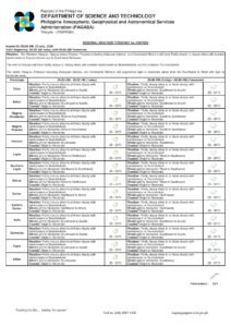
Thunderstorm Threats Over Visayas and Mindanao
For the Visayas, Mindanao, and sections of Southern Luzon not directly under the monsoon’s influence, Thursday’s weather will feature partly cloudy to cloudy skies with isolated rainshowers and thunderstorms. These disturbances stem from localized convective systems independent of the southwest monsoon, PAGASA explained.
Despite appearing less severe than conditions in Luzon, PAGASA cautions that these thunderstorms should not be taken lightly. Severe convective cells can dump intense, concentrated rainfall over a narrow area within a very short window — enough to overwhelm drainage systems and trigger flash flooding even when nearby communities remain dry. Residents across Eastern Visayas, Western Visayas, Central Visayas, the Zamboanga Peninsula, Northern Mindanao, the Davao Region, SOCCSKSARGEN, Caraga, and the Bangsamoro Autonomous Region in Muslim Mindanao (BARMM) are urged to remain watchful, particularly during afternoon and evening hours when convective activity typically peaks.
Wind Speeds and Coastal Sea Conditions
The southwest monsoon is generating strong winds and rough seas along the Philippine western seaboard. PAGASA reports that Northern Luzon, Central Luzon, and the western portions of Southern Luzon will experience moderate to strong southwesterly winds. Coastal waters in these zones are classified as moderate to rough, with wave heights ranging from 1.2 to 3.1 meters.
These conditions present genuine dangers to small watercraft. Fisherfolk and mariners operating along the western Luzon coastline — including waters off Ilocos Norte, Ilocos Sur, La Union, Pangasinan, Zambales, and Bataan facing the West Philippine Sea — are strongly encouraged by PAGASA to either exercise extreme caution or defer voyages until sea conditions improve.
Elsewhere in the country, winds will be light to moderate from the south to southwest. Coastal seas in those areas are expected to be slight to moderate, with wave heights of 0.6 to 1.5 meters. While generally manageable for most vessels, small bancas should still observe standard maritime precautions before heading out.
Metro Manila Temperature and Humidity
Cloud cover and rain have not significantly suppressed temperatures in the capital region. PAGASA’s Science Garden weather station in Diliman, Quezon City recorded a maximum temperature of 31.5°C at noon and a minimum of 25.3°C at 6:00 AM, covering the 24-hour period ending 8:00 PM on June 3, 2026. Relative humidity readings ranged from 64% to 95%, reflecting the heavy moisture content in the air mass brought by the habagat. The combination of heat and high humidity will produce a muggy, uncomfortable feel even during brief breaks between rain showers.
Tides and Astronomical Data for Metro Manila
Tidal predictions for Metro Manila, as provided by the National Mapping and Resource Information Authority (NAMRIA), show a high tide of 1.23 meters at 11:42 AM and a low tide of -0.12 meters at 8:41 PM on Thursday. Sunrise is at 5:26 AM and sunset at 6:23 PM. The moon stands at 85% illumination, with moonrise at 9:41 PM and moonset at 8:21 AM.
What Residents Should Do Today
PAGASA’s warnings come with clear guidance for Filipinos across the country. Flash floods can develop in a matter of minutes following a heavy cloudburst, particularly in low-elevation and historically flood-prone communities. Landslides pose the greatest threat in mountainous and hilly terrain where soil saturation from prior rainfall reduces ground stability.
Stay updated: Check PAGASA’s official forecasts regularly at pagasa.dost.gov.ph, as conditions can shift within hours. Local government units may issue supplementary advisories specific to your barangay or municipality.
Keep away from flood-prone zones: Never attempt to cross a flooded road or waterway regardless of how shallow the water appears. Swiftly moving floodwater carries far more force than most people anticipate.
Follow evacuation orders immediately: Residents in landslide-vulnerable barangays — especially in CAR’s mountain provinces — should not wait for conditions to deteriorate before acting on official evacuation directives.
Mariners and fishers: Small vessel operators along the western Luzon coastline must avoid areas where wave heights may reach up to 3.1 meters. Such conditions can capsize bancas and small fishing boats without warning, according to PAGASA.
Drivers and commuters: Reduced visibility during thunderstorms and the likelihood of flooded underpasses and streets — particularly in Metro Manila and other dense urban areas — mean motorists should budget additional travel time and avoid routes with a history of flooding.
The PAGASA 24-hour public weather forecast issued at 4:00 AM on June 4, 2026 remains in effect until 4:00 AM on June 5, 2026. Revised bulletins will be released as the weather situation evolves.
Originally reported by: PAGASA / wire reports