MANILA, June 23, 2026 — The Philippines is confronting a dangerous double weather situation this Tuesday as Super Typhoon Francisco (international name: Mekkhala) churns steadily toward Northern Luzon from the Pacific Ocean, while a vigorous Southwest Monsoon continues to unleash heavy rainfall across Southern Luzon, the Visayas, and Mindanao. The Philippine Atmospheric, Geophysical and Astronomical Services Administration (PAGASA) released its weather bulletin at 4:00 AM today, covering the forecast period through 4:00 AM on Wednesday, June 24, 2026.
From Cagayan in the far north to the southernmost tip of Mindanao, virtually every part of the archipelago is feeling the impact of at least one of these two active weather systems. Millions of Filipinos face heightened risks today, whether from the direct approach of a powerful typhoon or from the persistent, flood-inducing rains of the seasonal monsoon.
The Two Systems Shaping Today’s Weather
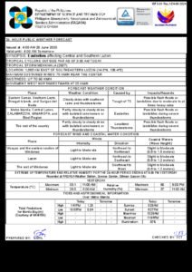
According to PAGASA, Super Typhoon Francisco is the more alarming of the two systems currently threatening the country. At 3:00 AM this morning, the typhoon’s center was located approximately 420 kilometers east of Aparri, Cagayan, at coordinates 18.5°N, 125.6°E. The system is packing maximum sustained winds of 185 km/h near its eye, with destructive gusts reaching up to 230 km/h. Francisco is moving west-northwestward at a measured pace of 10 km/h, placing it on a trajectory that points squarely at Northern Luzon.
A super typhoon represents the highest intensity classification for tropical cyclones — wind speeds at this level are sufficient to inflict catastrophic damage on structures, uproot trees, and trigger life-threatening storm surges along coastlines. As of 5:00 AM today, Francisco had not yet crossed into the Philippine Area of Responsibility (PAR), according to PAGASA. Despite this, the weather bureau stressed that the typhoon’s current course demands immediate preparedness actions from communities across Northern Luzon.
Separate from Francisco, the Southwest Monsoon — known locally as the habagat — is independently driving widespread rainfall across the southern portions of the country. PAGASA explained that the habagat is a recurring seasonal phenomenon in which warm, moisture-saturated winds sweep across the archipelago from the southwest during the mid-year period. An active habagat can sustain continuous, broad-area rainfall that, while lacking the dramatic wind intensity of a typhoon, is fully capable of triggering flash floods, river overflow, and deadly landslides — especially in areas already saturated from previous days of rain.
PAGASA also noted a third system: a Tropical Depression located some 2,680 kilometers east of Southeastern Luzon, carrying maximum sustained winds of 55 km/h. The agency said it remains at a very safe distance from the country for now but is being closely monitored for any signs of intensification or directional change.
Area-by-Area Weather Outlook
Northern Luzon
Of all the country’s regions, Northern Luzon faces the most urgent threat today. With Francisco positioned just 420 km to the east of Aparri and bearing down on a west-northwestward track, provinces such as Cagayan, Isabela, the Ilocos region, and the Cordillera Administrative Region are directly in the storm’s anticipated path. PAGASA’s forecast calls for moderate to strong westerly winds across the region, with coastal waters expected to turn rough to very rough, generating wave heights between 1.2 and 3.7 meters. Local governments, emergency management officers, and residents throughout Northern Luzon are urged to immediately begin preparation and preemptive measures as the typhoon’s exact track and intensity are refined in subsequent bulletins.
MIMAROPA and Southern Luzon
The island provinces of MIMAROPA — Mindoro, Marinduque, Romblon, and Palawan — will experience cloudy conditions with scattered rainshowers and thunderstorms, driven primarily by the Southwest Monsoon, the weather agency said. PAGASA warned that moderate to heavy rainfall in this region could trigger flash floods or landslides, particularly in upland communities and along steep terrain. Along MIMAROPA’s coastlines, light to moderate westerly winds are expected, with seas running at wave heights of 0.8 to 2.5 meters.
Metro Manila and Adjacent Provinces
The National Capital Region and its surrounding provinces will see partly cloudy to cloudy skies with isolated rainshowers throughout the day, according to PAGASA’s bulletin. The monsoon’s influence will be felt most strongly during the afternoon and evening hours, when atmospheric heating tends to amplify convective rainfall. Residents and commuters should prepare for intermittent downpours and the possibility of localized flooding in low-lying streets.
Visayas
The habagat is bearing down heavily on the entire Visayas region, where PAGASA forecasts cloudy skies with scattered to widespread rainshowers and thunderstorms. Eastern, Western, and Central Visayas all face elevated risks of flash flooding and landslides, especially in communities situated near river systems or areas with significant elevation change. Residents are advised to keep track of advisories from their respective local governments and to avoid traveling to flood-prone zones during peak rainfall hours.
Mindanao
Much like the Visayas to its north, Mindanao is under the broad influence of the active Southwest Monsoon. PAGASA’s forecast calls for cloudy skies with scattered rainshowers and thunderstorms across the island group. Communities in low-lying and mountainous areas face real risks of localized flooding and landslides. The agency advised residents in vulnerable barangays to remain in close contact with their local Disaster Risk Reduction and Management Offices (DRRMOs) and to heed any evacuation orders promptly.
Understanding What Each Advisory Means
Super Typhoon Francisco — Currently Outside PAR: PAGASA confirmed that as of this morning’s bulletin, no Tropical Cyclone Wind Signals have yet been raised over any province, as Francisco has not formally entered the PAR. However, the agency emphasized that the absence of wind signals does not equal an absence of danger. Given Francisco’s west-northwestward track toward Northern Luzon, signal raises are expected in the coming hours or days. Residents of Cagayan, Isabela, the Ilocos provinces, and the Cordillera must not wait for signals to be issued before acting. Secure your homes, assemble emergency kits with essential supplies, and identify the nearest evacuation centers in your community now.
Southwest Monsoon Rainfall Warnings: For residents of Southern Luzon, the Visayas, and Mindanao, the monsoon is generating precisely the conditions that PAGASA associates with flash flood and landslide risk. The weather bureau cautioned that communities receiving sustained heavy rain should not delay evacuation until floodwaters begin to rise. Early action saves lives. Residents are encouraged to familiarize themselves with PAGASA’s color-coded rainfall warning system to better understand the severity levels being communicated by local authorities.
Rough Seas Along Northern Luzon Coasts: PAGASA warned that wave heights of 1.2 to 3.7 meters are forecast along the seaboards of Northern Luzon — conditions classified as rough to very rough. Small fishing boats, outrigger vessels (bangka), and other light watercraft must remain in port. Even larger vessels should consult the Philippine Coast Guard before attempting to sail in these conditions.
Moderate Seas Around MIMAROPA: Wave heights of 0.8 to 2.5 meters are forecast for waters surrounding the MIMAROPA island group. While larger commercial vessels may manage these conditions with caution, small craft and fishing boats are at significant risk. PAGASA urged fisherfolk in this region to stay near shore or remain docked until conditions improve.
Practical Guidance for Those Affected
For Commuters and Urban Residents
Anyone traveling within Metro Manila, Southern Luzon, the Visayas, or Mindanao today should bring rain gear and allow extra time for their commute, as even moderate rainfall frequently causes flooding and severe traffic congestion in urban areas. In Northern Luzon, residents should stay alert for announcements from their local government units — class suspensions, work suspensions, and evacuation orders may be issued with little advance notice as Typhoon Francisco’s approach accelerates.
For Fisherfolk and Mariners
PAGASA’s advisory makes clear that the Northern Luzon coastline is particularly hazardous today. Wave heights reaching 3.7 meters are capable of capsizing small and medium-sized fishing vessels, and no fishing activity should be attempted in these waters. In the MIMAROPA zone, conditions are less severe but still warrant caution for small craft operators. The Philippine Coast Guard should be consulted before any maritime activity is undertaken in affected waters.
For Residents in Flood- and Landslide-Prone Areas
Whether you are in the habagat-drenched south or in the path of Francisco in the north, this is the moment to act — not to wait. PAGASA’s bulletin makes clear that the combination of saturated ground from recent rains and continued heavy rainfall creates ideal conditions for flash floods and landslides. Know your evacuation routes, keep important documents and emergency supplies within easy reach, and do not hesitate to leave if local officials issue an evacuation order.
PAGASA issues updated weather bulletins every six hours and will release additional advisories if the situation changes significantly — particularly if Francisco intensifies further or alters its projected path toward Northern Luzon.
Originally reported by: PAGASA / wire reports