Southwest Monsoon Puts Western Philippines on Flood and Landslide Watch
The Southwest Monsoon — the seasonal weather pattern Filipinos call Habagat — is making its presence felt strongly this Tuesday, June 2, 2026, drenching large portions of western Luzon and the western section of the Visayas with heavy rainfall and raising the danger of flash floods and landslides in vulnerable communities. The state weather bureau PAGASA released its 24-hour public weather bulletin at 4:00 AM today, covering conditions through 4:00 AM on Wednesday, June 3.
Residents across the western seaboard of the country — stretching from the Ilocos coastline in the north, through the provinces surrounding Manila Bay, and down into Western Visayas — are being urged to stay vigilant. Meanwhile, Mindanao and the eastern portions of the archipelago are expected to experience relatively calmer weather shaped primarily by localized thunderstorm activity rather than any large-scale weather system.
What Is Driving Today’s Weather
According to PAGASA, the Southwest Monsoon is the dominant weather system responsible for conditions across the country today. Moisture-heavy winds blowing in from the southwest are being funneled into the western coastal areas of Luzon and have extended their reach into the western Visayas. The rest of the Philippine landmass is experiencing weather driven by isolated, convective thunderstorm activity rather than the broader monsoon system.
PAGASA has identified flash floods and landslides as the primary public safety hazards for June 2. Communities situated near rivers, drainage channels, and elevated hillside terrain are strongly encouraged to monitor local advisories from their respective local disaster risk reduction and management councils (LDRRMCs) throughout the day.
Forecast for Luzon
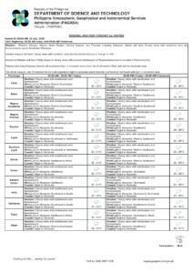
Zambales, Bataan, Cavite, Batangas, and Occidental Mindoro
These five provinces are bearing the most direct impact of the Southwest Monsoon today. PAGASA forecasts occasional rains for this cluster, with the agency warning explicitly of possible flash floods and landslides due to moderate to heavy rainfall. Upland and coastal barangays in these areas should closely monitor river levels and local drainage systems throughout the day.
Occidental Mindoro, which faces directly into the southwest winds along Luzon’s western coastline, is among the most exposed areas. Communities in hilly terrain there should remain on heightened alert. In the provinces of Cavite and Batangas, rural and suburban communities that sit alongside river systems fed by mountainous interiors face a credible flash flood risk that local government units should take seriously.
Metro Manila and Broader Luzon
Metro Manila can expect a wet Tuesday, PAGASA said. The forecast calls for cloudy skies with scattered rains and thunderstorms for the National Capital Region, with the Southwest Monsoon identified as the primary driver. Moderate to at times heavy rainfall is anticipated, and the agency maintains warnings of possible flash floods and landslides affecting the capital and surrounding areas.
The wet forecast extends across the entire Luzon landmass — from the Ilocos Region and the Cordillera Administrative Region in the far north, through Central Luzon and CALABARZON, and continuing through MIMAROPA and the Bicol Region in the south. Commuters and drivers across this wide area should prepare for reduced visibility during heavy rain episodes and the likelihood of flooding on low-lying roads and underpasses.
For Extreme Northern Luzon — including the northernmost sections of Ilocos Norte and Cagayan, as well as the Batanes and Babuyan island groups — PAGASA forecasts moderate southwest winds. Coastal waters in this zone are classified as moderate, with wave heights expected between 1.2 and 2.5 meters. Fisherfolk and mariners operating in these northern waters are advised to take appropriate precautions.
Forecast for the Visayas
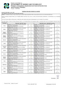
Western Visayas
The region of Western Visayas — comprising Iloilo, Capiz, Aklan, Antique, Guimaras, and Negros Occidental — falls under the direct influence of the Southwest Monsoon alongside much of Luzon, according to PAGASA. Cloudy skies with scattered rains and thunderstorms are expected, with moderate to at times heavy rainfall possible. Flash flood and landslide risks are flagged here as well, particularly in the mountainous interior portions of Negros Occidental and Iloilo’s eastern highlands.
Eastern and Central Visayas
The remainder of the Visayas — including Cebu, Bohol, Leyte, Samar, Negros Oriental, and Siquijor — is not directly affected by the Southwest Monsoon today. PAGASA said these areas will experience partly cloudy to cloudy skies with isolated rainshowers or thunderstorms, driven by localized convective activity. Although overall conditions are considerably less severe than those in western areas, PAGASA cautions that flash floods remain possible during intense or severe individual thunderstorm events. Residents should not underestimate the potential for sudden and powerful local downpours.
Forecast for Mindanao
Mindanao as a whole is placed within the “rest of the country” category in PAGASA’s June 2 bulletin, indicating that all major regions of the island group — including Davao Region, Northern Mindanao, the Zamboanga Peninsula, SOCCSKSARGEN, Caraga, and the Bangsamoro Autonomous Region in Muslim Mindanao — will see partly cloudy to cloudy skies with isolated rainshowers or thunderstorms fueled by localized convective activity.
While the threat level for Mindanao is considerably lower than that for western Luzon and Western Visayas, PAGASA still warns that flash floods are possible during severe thunderstorm episodes. Residents living near rivers and in low-lying areas throughout the island group are advised to remain alert to rapidly changing weather conditions.
Temperature and Humidity Readings
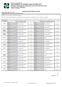
PAGASA’s weather monitoring station at Science Garden in Diliman, Quezon City recorded a peak temperature of 30.4°C at 3:00 PM yesterday, with the overnight low reaching 25.7°C at 5:00 AM. Relative humidity over the 24-hour period ending at 8:00 PM yesterday ranged from a maximum of 94 percent to a minimum of 75 percent. These readings are consistent with the warm, humid conditions that characterize the Southwest Monsoon season in the Philippines.
Wind and Sea Conditions
PAGASA has divided wind and sea condition forecasts into two zones. Over Extreme Northern Luzon, winds are moderate and coming from the southwest, with coastal waters classified as moderate and wave heights ranging from 1.2 to 2.5 meters. Fishing vessels and small watercraft in these northern waters should exercise caution before heading out.
Over the rest of the country, PAGASA reports light to moderate winds blowing from the southeast to southwest direction, with coastal waters ranging from slight to moderate — corresponding to wave heights between 0.6 and 2.5 meters. All mariners are urged to check the latest sea condition updates from PAGASA before putting out to sea, especially given the active monsoon environment in place.
Astronomical Data for Metro Manila
According to PAGASA, sunrise over Metro Manila today falls at 5:26 AM, with sunset at 6:22 PM. The moon is scheduled to rise at 8:08 PM and set at 6:36 AM, carrying a 96-percent illumination level — effectively a near-full moon. Tidal data for Manila Bay, as provided by the National Mapping and Resource Information Authority (NAMRIA), shows a high tide of 1.23 meters at 10:25 AM and a low tide of -0.16 meters at 7:18 PM.
Safety Advisories
PAGASA’s warnings on flash floods and landslides should be acted upon by residents living in or near the affected areas. Those in the provinces of Zambales, Bataan, Cavite, Batangas, and Occidental Mindoro — especially in riverside and hillside communities — are advised to monitor water levels closely and be prepared to evacuate immediately upon instruction from local authorities. The same level of preparedness applies to flood-prone communities in Metro Manila and Western Visayas during heavy monsoon rainfall events.
Drivers are reminded to slow down in low-visibility conditions, refrain from attempting to cross flooded roads, and observe all guidance issued by LDRRMCs. Residents in coastal areas should verify sea conditions with PAGASA before conducting any maritime activities today.
Originally reported by: PAGASA / wire reports