Monsoon season tightened its hold over the Philippines on Sunday, June 7, 2026, as the Southwest Monsoon — called Habagat in Filipino — pushed waves of moisture-laden air across Northern and Central Luzon. The Philippine Atmospheric, Geophysical and Astronomical Services Administration (PAGASA) released its 24-hour public weather forecast at 4:00 AM, covering the entire archipelago through 4:00 AM on Monday, June 8, and warning of scattered rains, thunderstorms, and serious risks of flash floods and landslides in multiple parts of the country.
No region — from the northernmost tip of Batanes down to Tawi-Tawi in the far south — is completely out of reach of weather disturbances today, PAGASA stressed in its bulletin.
What Is Driving Today’s Weather
The Southwest Monsoon is a recurring seasonal wind pattern that typically prevails over the western side of the Philippines between June and September each year. According to PAGASA, moisture-rich winds pushing in from the southwest interact with the country’s rugged mountain ranges — most dramatically in Luzon — generating significant cloud formation, heavy rainfall, and the conditions necessary for severe thunderstorms.
PAGASA’s official synopsis for June 7, 2026 identifies the Southwest Monsoon as the primary weather system affecting Northern and Central Luzon. Meanwhile, the rest of the country is expected to deal with localized convective thunderstorms that develop independently through daytime surface heating — a common afternoon and evening phenomenon during the rainy season.
Luzon Takes the Brunt
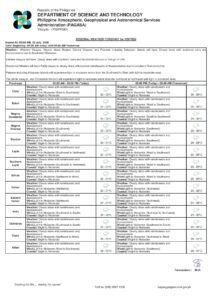
Ilocos Norte and Ilocos Sur: Occasional Rains Forecast
Along the northwestern coastline of Luzon, Ilocos Norte and Ilocos Sur sit directly under the monsoon’s path. PAGASA’s forecast calls for occasional rains throughout the forecast period in these two provinces. Although the term “occasional” suggests intermittent rather than continuous rainfall, the weather bureau cautioned that brief, intense rain bursts remain possible. Where rainfall becomes sustained or heavy, the risk of flash floods and landslides rises considerably.
Metro Manila, CAR, and Central Luzon: Scattered Rains and Thunderstorms
The most significantly affected zone under the monsoon’s direct influence covers a wide stretch of Luzon. Metro Manila, with its population of more than 13 million, is under a forecast of cloudy skies with scattered rains and thunderstorms. Commuters, outdoor workers, and residents in low-lying areas of the capital should anticipate rapidly changing conditions throughout the day.
The same weather outlook covers the Cordillera Administrative Region (CAR) — comprising the highland provinces of Abra, Apayao, Benguet, Ifugao, Kalinga, Mountain Province, and Baguio City — along with the lowland provinces of Pampanga, Bataan, Tarlac, Bulacan, Rizal, Cavite, and Batangas. The remaining Ilocos Region provinces of La Union and Pangasinan are likewise included in this broader forecast zone.
PAGASA explicitly warned of the “possible flash floods or landslides due to moderate to at times heavy rains” across this entire belt. People residing near rivers, drainage waterways, or steep slopes are strongly urged to monitor local government advisories and be prepared to evacuate should conditions worsen rapidly.
“Possible flash floods or landslides due to moderate to at times heavy rains” — PAGASA, 24-Hour Public Weather Forecast, 4:00 AM, June 7, 2026
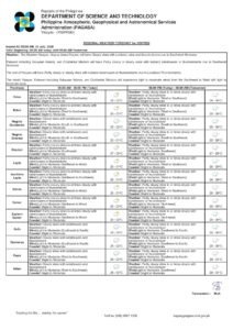
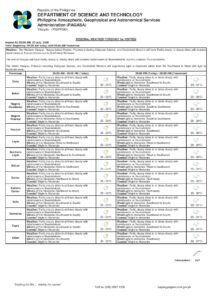
Visayas and Mindanao: Less Intense but Still Risky
For the Visayas and Mindanao, PAGASA’s forecast is comparatively milder — but residents should not take the softer language as a reason for complacency. The weather bureau projects partly cloudy to cloudy skies with isolated rain showers or thunderstorms across these areas, attributed to localized convective thunderstorms rather than direct monsoon influence.
Localized afternoon and evening thunderstorms can develop quickly and intensify without much warning, even in areas outside the main monsoon belt. PAGASA noted that these systems still carry the risk of flash floods or landslides during severe thunderstorm episodes.
Areas that fall under this outlook include Eastern Visayas, Western Visayas, Central Visayas, Zamboanga Peninsula, Northern Mindanao, Davao Region, SOCCSKSARGEN, BARMM, Caraga, and all other regions south of the Luzon monsoon zone. Residents in mountainous or low-lying coastal areas within these regions are advised to stay alert throughout the afternoon and evening hours when convective activity typically peaks.
Wind Conditions and Sea State
Wind and sea conditions on June 7 closely follow the monsoon pattern, according to PAGASA. Over Northern and Central Luzon, winds will be moderate and blowing from the southwest, consistent with the prevailing monsoon flow. Coastal waters in these areas are forecast to be moderate, with wave heights ranging from 1.2 to 2.1 meters. PAGASA advised fisherfolk and small vessel operators in these waters to exercise caution before setting out.
Across the rest of the Philippines, winds will be light to moderate, coming from the southeast to southwest. Coastal waters will be slight to moderate, with wave heights between 0.6 and 1.5 meters — generally manageable for larger vessels, though small fishing bancas are still advised to take care.
Metro Manila Temperature and Humidity
Based on data recorded at the PAGASA Weather Station in Science Garden, Diliman, Quezon City, Metro Manila temperatures during the 24-hour period ending at 8:00 PM on June 6, 2026, ranged from a minimum of 25.3°C — logged at 5:00 AM — to a maximum of 29.9°C, recorded at 2:00 PM. Relative humidity for the same period swung between 71% and 93%, a range that reflects the saturated, muggy air conditions typical of the Philippine monsoon season.
On overcast and rainy days such as today, peak temperatures in the capital may fall slightly below those of the previous day. However, the high humidity combined with any brief sunny spells between rain showers can still make conditions feel oppressively warm and uncomfortable.
Tidal Data for Manila Bay
PAGASA, drawing on tidal predictions provided by the National Mapping and Resource Information Authority (NAMRIA), released the following Manila Bay tide schedule for June 7, 2026: a high tide of 1.09 meters is expected at 1:54 PM, while a low tide of 0.05 meters will occur at 10:39 PM. Coastal communities along Manila Bay are advised to account for tidal conditions when evaluating flood risks from rainfall runoff, particularly during the afternoon high tide coinciding with expected monsoon rains.
Astronomical Reference Points
For planning purposes, sunrise over Metro Manila today is at 5:26 AM and sunset at 6:24 PM. The moon will rise at 11:38 PM and set at 10:55 AM, with an illumination level of 59%, placing it in a waxing gibbous phase.
Practical Safety Reminders for All Filipinos
Regardless of whether you are in the heart of monsoon-battered Metro Manila or in a Mindanao province seeing only isolated afternoon showers, PAGASA’s hazard advisories carry real weight. The onset of the rainy season brings with it predictable yet still dangerous threats that require active preparedness.
Stay away from flood-prone zones. Even a short, intense downpour can trigger rapid inundation in low-lying neighborhoods, underpasses, and areas adjacent to rivers and drainage channels. Never attempt to wade through or drive across flooded roads — the depth and current can be deceiving and deadly.
Heed landslide warnings immediately. Communities situated near hillsides, mountain slopes, or elevated terrain — particularly in CAR, the Ilocos provinces, and Rizal — should remain on alert for signs of soil saturation or ground movement following sustained rainfall. Early evacuation saves lives.
Keep emergency contacts ready. Local disaster risk reduction and management offices (LDRRMOs) and the national NDRRMC hotline should be on hand. Report rising water levels, blocked drainage, or signs of slope instability to local authorities without delay.
Protect vulnerable members of the household. Children, the elderly, and persons with disabilities require additional assistance during weather emergencies. Ensure that all household members know the evacuation plan and the location of the nearest evacuation center.
PAGASA continues to monitor developments and will issue updates as necessary. Filipinos are encouraged to check the weather bureau’s official website and social media channels for the latest bulletins throughout the day.
Originally reported by: PAGASA / wire reports