A tectonic earthquake measuring Magnitude 5.0 rattled the waters south of Balut Island in Davao Occidental on the evening of July 11, 2026, according to the Philippine Institute of Volcanology and Seismology under the Department of Science and Technology (PHIVOLCS-DOST). The tremor was detected at low instrumental intensities across multiple provinces and cities in Mindanao, and authorities have ruled out any structural damage from the event.
Details of the Seismic Event
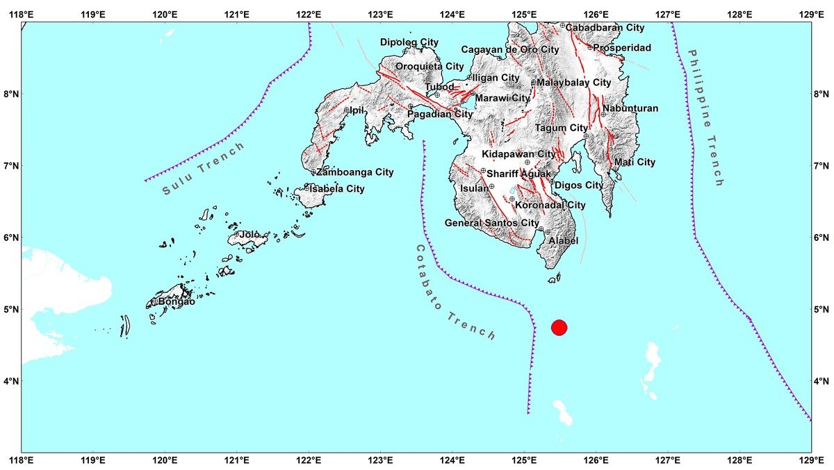
PHIVOLCS-DOST recorded the earthquake at precisely 6:51:06 in the evening, Philippine Standard Time, on Saturday, July 11, 2026. The epicenter was plotted approximately 75 kilometers south-southeast of Balut Island, within the jurisdiction of the Municipality of Sarangani in Davao Occidental, at geographic coordinates 4.73°N, 125.49°E.
The agency determined the focus depth at 22 kilometers below the surface and classified the earthquake’s origin as tectonic in nature — meaning it was generated by movement along fault structures rather than volcanic activity. PHIVOLCS-DOST issued its official bulletin for this event at 7:52 PM PHT the same evening.
Affected Areas and Intensity Readings
Based on readings from its nationwide seismic monitoring network, PHIVOLCS-DOST reported varying levels of instrumental intensity across several communities in southern Mindanao.
The highest instrumental intensity recorded was Intensity II, which was logged in two municipalities within Sarangani province: Kiamba and Malungon. Under the PHIVOLCS Earthquake Intensity Scale, an Intensity II reading indicates that the tremor was perceptible to a small number of people, particularly those who were at rest or in elevated floors, but produced no significant physical effects on structures or surroundings.
Intensity I readings — meaning the shaking was detectable only through seismic instruments and was imperceptible to people — were recorded across a broader area. PHIVOLCS-DOST listed the following locations at this intensity level: Maitum and Malapatan in Sarangani province; T’Boli in South Cotabato; the City of General Santos; Santa Maria in Davao Occidental; and the City of Digos in Davao del Sur.
In total, the tremor registered instrumentally across five distinct administrative areas: Sarangani, South Cotabato, Davao Occidental, Davao del Sur, and the City of General Santos.
No Damage, No Further Aftershocks Expected
PHIVOLCS-DOST stated clearly in its bulletin that no damage is anticipated as a result of this earthquake. The agency also noted that no additional aftershocks from this particular event are expected. The bulletin released at 7:52 PM on July 11, 2026 is designated as the sole advisory for this tremor unless new or additional data emerges that warrants an update.
Residents in affected areas were advised to monitor official government channels for any further developments, though the agency’s assessment at the time of publication indicated no cause for alarm.
Connection to the June 2026 Offshore Sarangani Earthquake Sequence
PHIVOLCS-DOST confirmed that the July 11 magnitude 5.0 tremor is an aftershock, and it is part of the continuing seismic sequence triggered by two significant earthquakes that struck the region in June 2026. Specifically, the agency identified the parent events as the Mw 7.8 Offshore Sarangani earthquake and the Mw 6.5 Offshore Davao Occidental earthquake, both of which occurred earlier in June 2026.
The agency did not include additional details about those earlier major events in this particular bulletin. However, the July 11 aftershock underscores that the seismic sequence from those powerful June earthquakes remains ongoing. Aftershocks of varying magnitudes are a normal geological consequence following major earthquakes and can continue for weeks, months, or even years after the main event, depending on the size and depth of the originating quake.
The Mw 7.8 main shock was among the strongest earthquakes to strike the southern Philippines in recent years, and PHIVOLCS-DOST’s continued monitoring reflects the importance of tracking residual seismic activity in the affected fault zone.
About the PHIVOLCS Earthquake Intensity Scale
The PHIVOLCS Earthquake Intensity Scale (PEIS) is the standard used in the Philippines to describe how strongly shaking is felt at any given location. Unlike magnitude — which measures the total energy released at the source — intensity describes the local effect on people, objects, and structures. Intensity I on this scale means the event was recorded only instrumentally, while Intensity II means it was noticed by very few persons. Higher intensities on the scale, such as Intensity V or above, are associated with more widespread perception and possible minor to moderate structural effects.
PHIVOLCS-DOST serves as the primary government agency responsible for earthquake monitoring, volcanic activity surveillance, and tsunami warning in the Philippines. Members of the public are encouraged to monitor real-time updates and official advisories through the agency’s official website at phivolcs.dost.gov.ph.
By the Numbers
- Mw 5.0 — Magnitude of the July 11, 2026 aftershock
- 6:51:06 PM PHT — Exact time the earthquake struck on July 11, 2026
- 75 kilometers — Distance south-southeast of Balut Island to the epicenter
- 22 kilometers — Recorded depth of focus
- 4.73°N, 125.49°E — Epicenter coordinates
- Mw 7.8 — Magnitude of the main Offshore Sarangani earthquake in June 2026
- Mw 6.5 — Magnitude of the Offshore Davao Occidental earthquake in June 2026
- 7:52 PM PHT — Time the official PHIVOLCS-DOST bulletin was issued
Why This Matters
The continued occurrence of aftershocks following the powerful Mw 7.8 Offshore Sarangani and Mw 6.5 Offshore Davao Occidental earthquakes of June 2026 signals that the affected fault zone has not yet fully stabilized, and communities across southern Mindanao remain in a period of elevated seismic vigilance. While PHIVOLCS-DOST has assessed that this particular Mw 5.0 tremor poses no damage risk, the sequence as a whole highlights the vulnerability of provinces such as Sarangani, Davao Occidental, and Davao del Sur to major seismic events. Sustained monitoring by PHIVOLCS-DOST and public awareness of official advisories remain essential for community preparedness in the region.
Source: PHIVOLCS-DOST official earthquake bulletin, July 11, 2026