A tectonic earthquake with a magnitude of 4.6 shook parts of the Visayas and Mindanao border region on the morning of Wednesday, May 20, 2026, with its effects reaching several towns in Southern Leyte. The Philippine Institute of Volcanology and Seismology (PHIVOLCS-DOST) recorded the event at exactly 10:26:46 AM and subsequently released an official bulletin at 11:30 AM the same day.
Origin Point and Technical Details
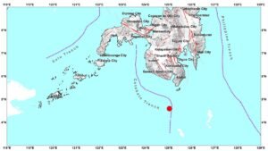
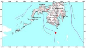
According to PHIVOLCS-DOST, the earthquake’s epicenter was pinpointed approximately 6 kilometers south 59° east of Burgos, in the province of Surigao del Norte. The precise geographic coordinates recorded were 9.99°N latitude and 126.12°E longitude. The quake originated at a focal depth of 21 kilometers beneath the earth’s surface and was classified as tectonic in nature, meaning it was generated by the movement of tectonic plates rather than volcanic activity.
PHIVOLCS-DOST noted that the depth and origin characteristics of this earthquake are consistent with tectonic stress activity common in the region, which sits within one of the most seismically active zones in the country.
Areas That Felt the Shaking
Despite originating in Surigao del Norte, the tremor’s effects extended northward into the island province of Southern Leyte. PHIVOLCS-DOST reported that four municipalities in Southern Leyte experienced the earthquake at Intensity II on the PHIVOLCS Earthquake Intensity Scale (PEIS): Pintuyan, San Juan, San Francisco, and San Ricardo.
At Intensity II, the shaking is generally described as weak and is typically perceptible only to a limited number of individuals — particularly those who are at rest, lying down, or occupying the upper floors of multi-story buildings. Most people going about normal activity outdoors or on ground level may not notice the movement at all.
Beyond resident-felt reports, instrumental monitoring conducted by PHIVOLCS-DOST also confirmed Intensity II ground shaking in two additional areas: San Francisco and Hinundayan, both located within Southern Leyte. These readings were captured through seismic monitoring instruments deployed across the province.
Meanwhile, Hilongos, a municipality in the neighboring province of Leyte, registered Intensity I — the lowest level on the PEIS scale. At this intensity, the earthquake is considered scarcely perceptible and is typically detectable only through sensitive scientific instruments, not by the general public.
No Damage Expected, No Aftershocks Anticipated
PHIVOLCS-DOST assessed that the May 20 earthquake does not pose any threat of structural damage to buildings or infrastructure in the affected areas. The agency further stated that no aftershocks are anticipated following this seismic event.
In its official bulletin, PHIVOLCS-DOST clarified that this particular report is intended to be the sole advisory issued for this earthquake, and that no follow-up bulletins will be released unless new or significant information warrants an update. This is standard protocol for lower-magnitude quakes that do not result in damage or significant aftershock activity.
Understanding Earthquake Intensity Levels
The PHIVOLCS Earthquake Intensity Scale, used by PHIVOLCS-DOST as the official measure for describing the strength of ground shaking felt by people and recorded by instruments, ranges from Intensity I (scarcely perceptible) to Intensity X (completely devastating). Wednesday’s earthquake fell within the lower end of the scale across all affected areas, indicating minimal risk to residents and properties.
Intensity II quakes, such as those felt in Southern Leyte towns during this event, are common in the Philippines given the country’s location along the Pacific Ring of Fire. They rarely cause alarm but serve as reminders of the ongoing seismic activity beneath the archipelago.
What the Public Should Do
PHIVOLCS-DOST advises the public to always rely on official channels for accurate and timely updates following any earthquake. Misinformation during seismic events can cause unnecessary panic, which is why the agency consistently reminds communities to verify reports through credible government sources.
For real-time earthquake bulletins, intensity maps, and other seismic information, the public may visit the official PHIVOLCS-DOST website at phivolcs.dost.gov.ph. Updates are also regularly posted on the agency’s official social media pages, which are monitored and updated around the clock by PHIVOLCS-DOST personnel.
The Philippines experiences thousands of earthquakes every year, the vast majority of which go unnoticed by the general population. Continuous monitoring by PHIVOLCS-DOST remains a critical component of the country’s disaster risk reduction and preparedness framework, ensuring that communities receive prompt and accurate information when seismic events occur.
Originally reported by: wire reports