Multiple municipalities throughout Quezon province experienced tremors Tuesday night after a 4.5-magnitude earthquake struck the area, with the Philippine Institute of Volcanology and Seismology (PHIVOLCS-DOST) confirming that structural damage is unlikely from the seismic event.
Seismic Event Specifications
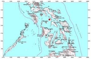
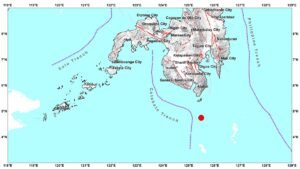
PHIVOLCS recorded the earthquake at exactly 6:40 PM Philippine Standard Time on April 15, 2026. The seismic activity originated from a relatively shallow depth of 4 kilometers beneath the Earth’s surface, with scientists pinpointing the epicenter at coordinates 15.04°N, 122.04°E—approximately 23 kilometers north 18 degrees east of Burdeos municipality.
The tremor was identified as tectonic in nature, indicating it stemmed from the shifting of underground rock formations along existing fault systems rather than volcanic processes. This shallow depth factor explains why the earthquake’s effects were widely perceived across the affected regions despite its moderate magnitude rating.
Geographic Impact Distribution
PHIVOLCS documented varying degrees of ground movement throughout the earthquake’s impact zone, with the most pronounced effects concentrated in northern sections of Quezon province. The municipalities of Burdeos and Panukulan registered Intensity III shaking levels, characterized as weak tremors that remain clearly noticeable to individuals inside buildings.
Several other Quezon communities experienced Intensity II effects, including Patnanungan, Jomalig, and Polillo municipalities. This intensity classification typically describes shaking that only a small number of people at rest can detect. PHIVOLCS seismic monitoring equipment simultaneously registered Intensity III readings in General Nakar, also located within Quezon province.
The earthquake’s influence reached into adjacent provinces, with barely detectable Intensity I shaking documented in Guinayangan and Infanta within Quezon province. Similar minimal ground movement was also recorded in Daet and Jose Panganiban, both situated in the neighboring province of Camarines Norte.
Official Damage Projections
According to PHIVOLCS assessments, this seismic event is not anticipated to cause structural damage to buildings or infrastructure within the affected areas. The agency also indicated that aftershock activity is not expected to follow this particular earthquake.
The scientific organization emphasized that this would represent their final official communication regarding the earthquake unless new developments or additional data warrant further updates to the public.
Technical Analysis and Context
The classification of this earthquake as tectonic provides important context about its underlying causes. Tectonic earthquakes occur when accumulated stress along fault lines reaches critical levels, causing sudden rock displacement beneath the surface. This differs significantly from volcanic earthquakes, which result from magma movement or volcanic processes.
The 4-kilometer depth measurement places this earthquake in the shallow category, which typically produces more noticeable surface effects compared to deeper seismic events of similar magnitude. This depth factor explains why residents across multiple municipalities could distinctly feel the ground movement despite the relatively moderate 4.5 magnitude rating.
Official Response Timeline
PHIVOLCS released their comprehensive earthquake information bulletin at 7:35 PM on April 15, approximately 55 minutes following the actual seismic event. This response timeframe allowed the agency to collect preliminary data from their monitoring network and conduct initial assessments before providing official guidance to affected communities.
The bulletin provided residents with authoritative confirmation of the earthquake’s characteristics and helped dispel uncertainty about the tremor’s intensity and potential consequences.
Public Information Resources
Citizens seeking additional earthquake information or future updates can access official PHIVOLCS communications through their website at phivolcs.dost.gov.ph. The agency maintains real-time monitoring systems and regularly publishes seismic activity reports for public awareness and safety purposes.
Residents in earthquake-prone areas are encouraged to stay informed about seismic activity through these official channels rather than relying on unverified sources or social media speculation.