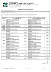
DUMAGUETE CITY, Negros Oriental — July 1, 2026 — The southwest monsoon has firmly taken hold over the Visayas, and Negros Oriental is in for several consecutive days of rain, thunderstorms, and unsettled coastal waters. PAGASA’s regional forecast, released at 5:00 AM on Wednesday, places the entire Visayas region — including Negros Oriental, Siquijor, and Cebu — under cloudy skies with active rainshowers and thunderstorm activity through at least Friday.
The forecast is not limited to a single day. According to PAGASA’s extended weather outlook, issued at 9:00 AM on June 30, 2026, the same combination of overcast skies, rain, and moderate coastal swells is expected to persist on Thursday and Friday as well, with winds continuing to blow from the southwest to southeast direction across those three days.
The Habagat Is in Full Force
The weather pattern driving conditions across Negros Oriental and the rest of the Visayas this week is the habagat — the Philippine term for the southwest monsoon. This seasonal wind system, which typically asserts itself from June through September, draws warm and moisture-saturated air from the sea over land. The result is the persistent cloudiness, frequent rainshowers, and sudden thunderstorms that characterize the Philippine rainy season at its most active.
PAGASA’s data shows winds blowing consistently from the southwest to southeast direction, a hallmark indicator of habagat influence. For residents of Negros Oriental, this means the wet conditions are not a passing weather disturbance but rather the onset of weeks of sustained monsoon activity. Isolated dry spells may occur between rain bouts, but the overall pattern will remain unsettled.
It is also worth noting, according to PAGASA’s website data referenced in the forecast, that while an active Tropical Cyclone Warning for Shipping was indicated on the PAGASA portal at the time of the forecast, no tropical cyclone wind signals or storm surge alerts have been issued for Negros Oriental or the broader Visayas region. Residents are advised to monitor pagasa.dost.gov.ph directly for any updates on that matter, as conditions can change.
Today’s Forecast: What to Expect on July 1
PAGASA’s forecast for the Visayas on Wednesday, July 1, 2026, covers a wide swath of the region, including Dumaguete City and surrounding municipalities such as Bayawan, Bais, Guihulngan, and Mabinay in Negros Oriental, as well as Siquijor Island and Cebu’s coastline. The specific conditions forecast for the day are as follows:
- Sky condition: Cloudy with rainshowers and thunderstorms
- Temperature range: 26°C (low) to 31°C (high)
- Wind speed: Light to moderate
- Wind direction: Southwest to southeast
- Coastal water condition: Slight to moderate
Rainshowers are expected to be intermittent rather than continuous throughout the day, meaning there may be brief dry windows. However, PAGASA’s inclusion of thunderstorms in the forecast means that heavier, more intense downpours can develop rapidly and at any hour, so residents should not be caught off guard by sudden changes in weather intensity.
By the Numbers
- 26°C–31°C — temperature range for Negros Oriental and the Visayas on July 1
- 26°C–30°C — temperature range forecast for Thursday, July 2
- 0.5–1.25 meters — wave height range for “slight” sea conditions
- 1.25–2.5 meters — wave height range for “moderate” sea conditions
- 3 consecutive days — duration of wet weather forecast (July 1–3)
- 5:00 AM — time PAGASA’s regional forecast was issued on July 1
- 9:00 AM, June 30 — time PAGASA’s extended outlook was released
Understanding the Coastal Water Rating
PAGASA has classified today’s coastal waters as “slight to moderate” — a rating that carries real implications for sea travel and fishing operations across the province. According to the weather agency’s classifications, slight seas correspond to wave heights of approximately 0.5 to 1.25 meters, which are manageable for larger commercial vessels but already pose a risk for small fishing boats and traditional outrigger bancas. Moderate seas, defined as wave heights of roughly 1.25 to 2.5 meters, present significantly more danger, with the potential to capsize small watercraft and cause considerable rolling and discomfort aboard inter-island ferries.
Because the forecast covers a range spanning both categories, actual conditions may vary depending on the specific sea route, the time of day, and local wind intensity. PAGASA advises that small boat operators exercise heightened caution under these conditions.
Guidance by Sector: Who Needs to Take Note
Ferry Passengers and Inter-Island Travelers
Anyone planning to take an inter-island vessel today — whether between Dumaguete and Siquijor, or on longer routes to Cebu aboard OceanJet, SuperCat, or similar carriers — should contact their ferry operator or check port conditions before departing for the terminal. According to PAGASA, slight to moderate coastal swells can lead to trip delays, route cancellations, or an unusually rough crossing. Passengers who are prone to seasickness should take appropriate precautions, and those traveling with young children or elderly companions should weigh the weather conditions carefully before proceeding. Ports in Bayawan and Bais may face comparable conditions for vessels on southern routes.
Fisherfolk and Small-Boat Operators
For fishing communities along the Negros Oriental coastline — particularly those operating small bancas out of Sibulan, Dauin, Zamboanguita, and the barangays fronting Tañon Strait — today’s conditions demand careful judgment. PAGASA’s forecast of light to moderate winds combined with slight to moderate coastal swells, layered on top of the risk of sudden thunderstorms, creates a potentially dangerous environment for small, low-powered watercraft. If going out to sea is unavoidable, fisherfolk are strongly urged not to go alone, to inform someone onshore of their intended route, and to return to shore immediately at the first sign of darkening clouds or building swells. Thunderstorms during habagat season can develop with very little warning.
Farmers and Upland Agricultural Workers
In the upland municipalities of Guihulngan, La Libertad, Tayasan, and Mabinay, the ongoing monsoon rains present a dual reality for farmers. The sustained moisture from habagat rainfall is generally beneficial for crops in the growing phase, but the accompanying risks — standing water in fields, muddy and slippery terrain, and the possibility of flash flooding in sloped or low-lying agricultural land — are genuine hazards. Agricultural workers should avoid remaining in open, elevated fields during thunderstorms. Lightning is a lethal risk in open terrain, and the standard safety guideline applies: seek covered shelter immediately upon hearing thunder, and wait at least 30 minutes after the last thunderclap before returning to the field.
Students, Parents, and School Commuters
Parents sending children to school on Wednesday should ensure they are equipped for rain — waterproof school bags, umbrellas or raincoats, and footwear suited for wet and possibly flooded streets. PAGASA’s forecast points to likely morning showers and the potential for intense afternoon thunderstorms, which tend to peak in the late morning to early afternoon hours. Families whose children attend schools near drainage canals, flood-prone roads, or low-lying areas should monitor conditions closely throughout the day. Updates from the Department of Education’s Negros Oriental division regarding possible class suspensions due to deteriorating weather should be watched closely.
Outdoor Workers and Event Organizers
Construction crews, street vendors, market stallholders, and other outdoor workers in Dumaguete City, Bayawan, and other urban centers across Negros Oriental should plan for intermittent to sustained rain during the day. Those with tarpaulin-covered stalls or temporary structures should ensure these are properly secured before thunderstorm conditions arrive. Organizers of outdoor community events, sports activities, or trade fairs scheduled for Wednesday should have a covered fallback venue identified in advance. With PAGASA confirming that similar wet weather is forecast through Thursday and Friday, events later this week face the same planning challenge.
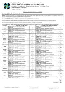
Three-Day Outlook: July 1 to July 3
Based on PAGASA’s extended weather outlook issued on June 30, 2026, the wet and unsettled pattern will carry through the rest of the workweek. The three-day snapshot for the Visayas, as reported by PAGASA, is as follows:
- Wednesday, July 1: 26°C–31°C | Light to moderate winds | SW to SE direction | Slight to moderate coastal waters
- Thursday, July 2: 26°C–30°C | Light to moderate winds | SW to South direction | Slight to moderate coastal waters
- Friday, July 3: Continued cloudy skies with rainshowers and thunderstorms | Similar wind and coastal water conditions expected
The slight drop in maximum temperature from 31°C on Wednesday to 30°C on Thursday is consistent with heavier cloud cover limiting daytime solar heating — a common feature of active monsoon days. PAGASA advises residents and travelers to revisit the forecast daily, as the agency updates its regional outlooks regularly and conditions can shift within the forecast window.
Why This Matters
The southwest monsoon’s firm establishment over Negros Oriental and the Visayas signals that the rainy season is now in full swing, with sustained wet weather expected not just this week but potentially for months. The combination of thunderstorms and slight-to-moderate coastal swells poses direct safety risks for fisherfolk, inter-island ferry passengers, and outdoor workers — groups that depend on favorable weather for both their livelihoods and their safety. With the wet pattern confirmed to persist through at least July 3 by PAGASA, early preparation and continuous monitoring of official weather advisories are essential for communities across the province.
Source: Breaking News Negros Oriental (breakingnewsnegrosoriental.com), based on PAGASA regional forecast data