The Philippine archipelago will experience thunderstorms and rain showers today as easterly winds continue to influence weather patterns across the nation, creating conditions that may disrupt routine activities and increase flooding potential in severely affected locations, according to the Philippine Atmospheric, Geophysical and Astronomical Services Administration (PAGASA).
PAGASA’s 24-hour weather bulletin, released at 4:00 AM on April 21, 2026, and effective until 4:00 AM the following day, shows that easterlies—moisture-laden winds originating from the Pacific Ocean—continue to impact the Visayas, Mindanao, and Southern Luzon regions, creating volatile atmospheric conditions throughout the country.
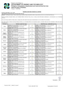
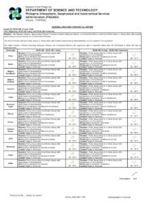
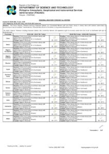
Nationwide Weather Pattern
Cloudy to partly cloudy skies accompanied by scattered rainshowers and thunderstorms will prevail across all Philippine regions today. Although weather conditions appear uniform nationally, PAGASA’s meteorological assessment reveals distinct atmospheric drivers affecting northern versus southern areas of the archipelago.
Citizens should remain alert for potential flash flooding and landslides during intense thunderstorm episodes, as the weather service stresses the importance of maintaining vigilance and implementing appropriate safety protocols in all potentially affected zones.
Visayas and Mindanao Conditions
Easterly wind patterns will generate cloudy to partly cloudy conditions with scattered thunderstorms and rainshowers across the entire Visayas archipelago. This encompasses Western Visayas, Central Visayas, and Eastern Visayas regions, affecting provinces such as Aklan, Antique, Capiz, Guimaras, Iloilo, Negros Occidental, Bohol, Cebu, Negros Oriental, Siquijor, Biliran, Eastern Samar, Leyte, Northern Samar, Samar, Southern Leyte, and Tacloban City.
Mindanao’s complete territory will encounter similar atmospheric conditions, with cloudy to partly cloudy skies and intermittent thunderstorms and rainshowers resulting from persistent easterlies. Affected areas include the Zamboanga Peninsula, Northern Mindanao, Davao Region, SOCCSKSARGEN, CARAGA, and the Bangsamoro Autonomous Region in Muslim Mindanao.
Metro Manila and surrounding regions including CALABARZON (Cavite, Laguna, Batangas, Rizal, and Quezon), MIMAROPA (Occidental Mindoro, Oriental Mindoro, Marinduque, Romblon, and Palawan), and the Bicol Region will also experience cloudy to partly cloudy conditions with scattered rainshowers and thunderstorms driven by easterly influences.
Northern Luzon Weather Outlook
Remaining Luzon areas, including the Cordillera Administrative Region, Ilocos Region, and Cagayan Valley, will encounter comparable weather conditions featuring cloudy to partly cloudy skies with scattered thunderstorms and rainshowers. These atmospheric disturbances stem from localized thunderstorm development rather than the easterlies impacting southern territories.
Although meteorological causes differ between regions, Northern Luzon residents should anticipate similar weather impacts and maintain equivalent preparedness levels as citizens in other affected areas nationwide.
Marine and Wind Forecasts
Wind patterns and ocean wave conditions will vary significantly across the Philippine archipelago, with eastern coastlines experiencing stronger conditions due to direct easterly wind exposure.
Eastern portions of Southern Luzon, Visayas, and Mindanao will encounter moderate northeast to east winds, creating coastal wave conditions measuring 1.5 to 2.5 meters in height. Small boats and fishing vessels should exercise enhanced caution when operating in these maritime zones.
Northern and Central Luzon areas will experience light to moderate east to southeast wind conditions, producing slight to moderate coastal waters with wave heights ranging from 0.6 to 2.5 meters. These conditions present more favorable circumstances for marine operations compared to eastern coastal regions.
Remaining national areas will face light to moderate east to northeast winds, also creating slight to moderate coastal water conditions. Wave patterns in these zones should remain within acceptable parameters for most marine activities, although standard maritime safety measures remain recommended.
Temperature and Atmospheric Data
Temperature measurements from PAGASA’s Science Garden monitoring station in Diliman, Quezon City, documented significant temperature variations during the 24-hour observation period concluding at 8:00 PM yesterday. Maximum temperatures peaked at 33.3 degrees Celsius recorded at 4:20 PM, while minimum temperatures decreased to 26.7 degrees Celsius at 5:00 AM.
Relative humidity measurements ranged between 68 percent (recorded at 5:00 AM) and 45 percent (measured at 4:00 PM), demonstrating normal atmospheric moisture fluctuations throughout the daily cycle.
Public Safety Guidelines and Emergency Preparedness
Considering projected weather conditions, PAGASA stresses the critical importance of emergency readiness, particularly concerning flash flood and landslide dangers during severe thunderstorm episodes. Communities located in flood-prone areas, riverside locations, and mountainous terrain should exercise heightened caution.
Regional government agencies and emergency response organizations should maintain close coordination with local communities to ensure immediate response capabilities during extreme weather incidents. Emergency evacuation procedures should undergo review while communication systems remain operational.
Vehicle operators should implement additional safety measures during precipitation events, including reduced speeds and increased following distances. Citizens should seek appropriate shelter during thunderstorm activity and avoid traversing flooded areas where water depth remains unknown.
Farming communities should protect crops and animals where feasible, while construction operations and outdoor workplace environments should establish weather-appropriate safety standards.
Transportation and Aviation Impacts
Diverse wind and wave patterns across different regions require careful consideration from marine transportation providers. Eastern coastal areas face moderate conditions with elevated wave activity, while most remaining areas maintain acceptable conditions for sea transportation.
Air travelers and aviation personnel should expect potential delays or routing modifications due to thunderstorm development, especially during afternoon and evening periods when convective weather activity typically escalates.
Maritime fishing operations in eastern waters should closely monitor weather developments and consider modifying departure schedules or fishing locations based on prevailing conditions and wave predictions.
Ongoing Weather Surveillance
Current atmospheric patterns represent characteristic easterly influences typical for this seasonal period, transporting moisture-rich air masses from the Pacific Ocean across the Philippine island chain. While today’s forecast suggests generally manageable conditions, potential severe localized thunderstorm development necessitates continuous monitoring.
Atmospheric conditions may shift rapidly during thunderstorm formation phases, making persistent weather surveillance crucial for public safety and operational planning across all economic sectors.
Citizens should regularly check official PAGASA weather updates at pagasa.dost.gov.ph for current weather information and emergency warnings.