Habagat Takes Hold Over Much of Luzon
Wednesday, June 3, 2026 finds the southwest monsoon — known locally as habagat — firmly in control of weather conditions across a significant stretch of the Philippine archipelago. Moisture-laden winds sweeping in from the southwest are delivering persistent and at times intense rainfall across Northern Luzon, Central Luzon, and the western portions of Southern Luzon, while the remaining regions of the country deal with isolated thunderstorm activity. The Philippine Atmospheric, Geophysical and Astronomical Services Administration (PAGASA) released its 24-hour public weather forecast at 4:00 AM on June 3, covering the period through 4:00 AM on June 4, and urged communities — especially those in low-lying zones and mountainous terrain — to stay alert against flash floods and landslides.
Dominant Weather Pattern Explained
According to PAGASA, the habagat is the primary driver of today’s weather, with its effects most pronounced along the country’s western coastline where prevailing winds are pushing heavy moisture onto terrain that, in many areas, may already be saturated from earlier rains. Northern Luzon, Central Luzon, and the western side of Southern Luzon bear the brunt of this system.
The rest of the archipelago — including the eastern sections of Luzon, the Visayas island group, and Mindanao — is not under the monsoon’s direct influence. Instead, those areas are seeing convective or localized thunderstorm activity, which can still produce sudden, intense downpours capable of triggering flash floods in vulnerable communities. PAGASA has identified flash floods and landslides as the principal hazards for the day across multiple regions of the country.
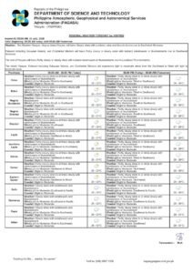
Metro Manila and Key Luzon Provinces
Metro Manila residents should brace for intermittent rainfall throughout the day, a direct consequence of the southwest monsoon, according to PAGASA’s forecast bulletin. The following provinces fall under the same weather advisory: Pangasinan, Zambales, Bataan, Tarlac, Pampanga, Bulacan, Cavite, Batangas, Occidental Mindoro, and Palawan.
In all of these areas, rainfall may build to moderate or heavy intensities at various points during the day, elevating the threat of flash floods in low-elevation communities and landslides along hilly or upland terrain. Urban flooding is a realistic concern for Metro Manila, particularly in streets, underpasses, and drainage-prone districts that have historically experienced inundation during heavy monsoon rains. Commuters should plan for possible traffic disruptions during peak downpour periods.
Northern and Eastern Luzon Under Cloudy Skies
A broader arc of Luzon faces overcast conditions and unsettled weather today. Cagayan Valley — covering provinces such as Isabela and Cagayan — and the Cordillera Administrative Region (CAR), which encompasses Kalinga, Apayao, Abra, Benguet, Ifugao, and Mountain Province, are forecast to see cloudy skies with scattered rains and occasional thunderstorms. The same general outlook applies to the rest of the Ilocos Region, the remaining provinces of Central Luzon, the balance of CALABARZON, and the remaining areas of MIMAROPA.
PAGASA cautions that rainfall intensities in these zones can reach moderate to heavy levels, with embedded thunderstorms heightening the risk of flash floods and landslides. Communities perched along mountain slopes in the Cordillera and settlements beside rivers in Cagayan Valley face elevated vulnerability and are strongly encouraged to maintain active coordination with their local disaster risk reduction and management offices (LDRRMOs).
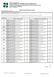
Visayas: Isolated Showers from Thunderstorm Activity
Across the Visayas — Western, Central, and Eastern — the forecast calls for partly cloudy to cloudy skies with isolated rainshowers or thunderstorms today. PAGASA attributes these disturbances to localized convective activity rather than the monsoon itself, though such storms can still generate hazardous conditions in a short span of time.
Flash floods and landslides remain a concern during severe thunderstorm episodes, and provinces with known flood-prone lowlands and coastal communities should maintain readiness. Marine conditions over Visayan waters are expected to be slight to moderate, with wave heights ranging from 0.6 to 1.8 meters, accompanied by light to moderate winds blowing from the southeast to south.
Mindanao: Calm Skies, Isolated Storms
Mindanao shares a similar forecast to the Visayas — partly cloudy to cloudy skies with isolated rainshowers or thunderstorms fueled by localized thunderstorm systems, the state weather bureau reported. Residents in areas susceptible to flooding and landslides are advised to stay updated through their local government units and barangay officials, particularly if storm activity intensifies.
Coastal waters surrounding Mindanao are the gentlest in the country today, with wave heights of just 0.6 to 1.2 meters classified as slight to moderate, and winds blowing at light to moderate speeds with variable direction — making this the most favorable maritime environment nationwide on this date.
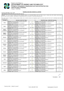
Rough Seas Along Western Luzon
Mariners and fishing communities operating off Northern Luzon, Central Luzon, and the western section of Southern Luzon face the most hazardous maritime conditions today. PAGASA forecasts moderate to strong southwesterly winds in these waters, with wave heights climbing to between 1.2 and 2.8 meters — classified as moderate to rough. Fishermen, small vessel operators, and seafarers in these specific waters are strongly advised to suspend or postpone sea travel until conditions improve.
Over the Visayas and the rest of Luzon, winds will be lighter — from the southeast to south at light to moderate speeds — with wave heights of 0.6 to 1.8 meters placing those waters in the slight to moderate range.
Temperature and Humidity Readings
Data recorded at the PAGASA Weather Station located in Science Garden, Diliman, Quezon City shows that for the 24-hour window ending at 8:00 PM on June 2, the temperature peaked at 31.0°C at 1:00 PM and fell to a minimum of 25.0°C at 6:00 AM. Relative humidity fluctuated between a high of 95% and a low of 63%, figures consistent with the oppressively moist atmosphere that characterizes the monsoon season.
During brief breaks in cloud cover, the combination of elevated humidity and residual warmth may make conditions feel particularly uncomfortable, especially in dense urban settings like Metro Manila.
Astronomical Data for Metro Manila
For planning purposes, PAGASA notes that sunrise today falls at 5:26 AM and sunset at 6:23 PM. The moon rises at 8:56 PM and sets at 7:29 AM, with an illumination of 91%, putting it just short of a full moon.
Safety Precautions to Keep in Mind
PAGASA’s weather advisory places particular emphasis on preparedness in flood- and landslide-prone communities. The state weather bureau urges the public to observe the following safety measures throughout the day:
- Do not attempt to cross flooded roads, rivers, or bridges, even when water does not appear dangerously deep.
- Households situated near slopes, ravines, riverbanks, or drainage channels should be ready to evacuate promptly when local authorities issue the order.
- Fisherfolk and those operating watercraft should consult PAGASA’s latest coastal water bulletins before departing, paying special attention to warnings covering the western seaboard of Luzon.
- Emergency supplies, including food, water, medicines, and important documents, should be kept within easy reach.
- Stay connected with barangay officials and local government units, who will relay real-time advisories as ground conditions evolve.
The public is encouraged to monitor official forecasts and updates directly through the PAGASA website at pagasa.dost.gov.ph for the latest bulletins as the weather system develops.
Originally reported by: wire reports