DUMAGUETE CITY, Negros Oriental — June 29, 2026 — Wet and stormy conditions are expected to grip the Visayas region this Monday, with the Philippine Atmospheric, Geophysical and Astronomical Services Administration (PAGASA) placing the entire region under a forecast of cloudy skies, rainshowers, and thunderstorms. The advisory covers Negros Oriental, Siquijor, Cebu, and surrounding provinces, and carries practical implications for seafarers, farmers, students, and anyone with outdoor plans for the day.
PAGASA released its Visayas Regional Forecast at 5:00 AM on June 29, 2026. A complementary extended weather outlook had already been issued the previous morning — at 9:00 AM on June 28, 2026 — providing residents and local government units with an advance look at conditions expected to persist through the early part of the following week.
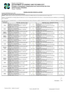
Forecast Details for June 29
According to PAGASA, prevailing winds across the Visayas on Monday are blowing from the northwest to north at light to moderate speeds. The state weather bureau did not explicitly identify a single named weather system as the driver of current conditions in the available forecast data, but the wind direction is consistent with weather patterns typical of this period in the Visayas calendar. Residents are encouraged to check the full bulletin at pagasa.dost.gov.ph for any accompanying named-system advisory.
The core forecast conditions for the Visayas, as issued by PAGASA for Monday, June 29, are as follows:
- Sky condition: Cloudy with rainshowers and thunderstorms
- Temperature range: 26°C (low) to 32°C (high)
- Wind speed: Light to moderate
- Wind direction: Northwest to North
- Coastal waters: Slight to moderate
PAGASA’s Visayas forecast page also carries a secondary forecast box — believed to correspond to a sub-region within the broader Visayas area — that shows a slightly lower temperature ceiling of 30°C, with winds shifting from northwest to southwest. Coastal conditions in that sub-region are similarly rated as slight to moderate, and the dominant weather feature of rainshowers and thunderstorms remains unchanged. This indicates some variability across the region, but the overall picture is one of unsettled, rainy weather throughout.
For Negros Oriental specifically, PAGASA’s forecast covers municipalities and cities across the province — among them Dumaguete City, Bais, Bayawan, Guihulngan, Canlaon, and Mabinay — where residents should brace for intermittent rainfall during the day, with heavier downpours and thunder most likely during the afternoon hours, when solar heating intensifies convective activity in the atmosphere. Siquijor Island, which lies just across a short sea channel from Negros Oriental, also falls under the same Visayas forecast and can expect comparable conditions.
By the Numbers
- Forecast issued: 5:00 AM, June 29, 2026 (PAGASA Visayas Regional Forecast)
- Extended outlook issued: 9:00 AM, June 28, 2026
- Temperature range (June 29): 26°C to 32°C
- Secondary sub-region temperature ceiling: 30°C
- Slight seas wave height: approximately 0.1 to 0.5 meters
- Moderate seas wave height: up to 1.25 meters or more
- Extended outlook — June 29 (Sunday label): 27°C–32°C, light to moderate winds, southwest to west
- Extended outlook — June 30 (Monday label): 26°C–32°C, light to moderate winds, southwest to northwest
- Extended outlook — July 1 (Tuesday label): 25°C–31°C, light to moderate winds, southwest to south
What the Forecast Terms Mean in Plain Language
For those unfamiliar with PAGASA’s standard forecast terminology, a brief explanation helps translate the bulletin into practical guidance.
“Slight to moderate” coastal conditions, according to standard maritime classifications, correspond to wave heights ranging from roughly 0.1 to 0.5 meters on the slight end, and up to 1.25 meters or beyond for moderate seas. While larger ferries and cargo vessels can generally navigate these waters safely, small outrigger fishing boats — known locally as bancas — may find these conditions challenging, particularly when combined with the added hazard of active thunderstorms.
“Light to moderate” winds are generally not destructive on land — expect leaf and branch movement but no structural damage under typical circumstances. At sea, however, even moderate winds compound wave action and make maneuvering small watercraft considerably more difficult.
“Cloudy skies with rainshowers and thunderstorms” does not imply continuous rainfall throughout the entire day. PAGASA uses this phrasing to indicate that rain is expected at some point during the day, with the additional possibility of lightning, thunder, and the sudden intense downpours that typically accompany convective storm activity.
Guidance for Specific Groups
Inter-Island Passengers and Ferry Travelers
Travelers planning sea crossings — including routes linking Dumaguete to Cebu or Siquijor served by operators such as OceanJet and other inter-island ferry lines — are advised to confirm departure schedules with their shipping lines before proceeding to port. PAGASA has not issued a gale warning based on currently available data, but slight to moderate seas coupled with thunderstorm activity can produce rapidly changing conditions at sea. Passengers with flexible travel windows are encouraged to verify their vessel’s status in advance.
Fisherfolk and Small-Boat Operators
Fisherfolk working the waters around Negros Oriental, Siquijor, and the Tañon Strait should take particular care on Monday. Thunderstorms carry a direct lightning risk for anyone on open water, and moderate sea conditions can make a quick return to shore difficult if weather deteriorates suddenly. Those who must go out are urged to remain close to shore and to head back before the afternoon, when thunderstorm activity typically peaks.
Farmers and Agricultural Workers
Agricultural communities in Negros Oriental — including upland barangays in Guihulngan, Canlaon, and Bayawan — should factor sustained cloud cover and rain into their work schedules. Crops ready for harvest or undergoing post-harvest drying should be secured ahead of heavier rainfall. On the other hand, the state weather bureau’s forecast of continued moisture through the week can benefit crops still in the growing phase, provided that field drainage is properly maintained.
Students, Parents, and Schools
Parents sending children to school on Monday should ensure that rain gear — umbrellas, raincoats, and waterproof bags — is packed. PAGASA’s forecast does not constitute a weather emergency that would automatically trigger class suspensions, but the combination of rainshowers and potential thunderstorms means conditions could deteriorate quickly. Local government units will issue their own decisions on class suspensions; parents are advised to monitor official LGU announcements.
Outdoor Workers and Event Organizers
Construction crews, road workers, and others engaged in outdoor labor should prepare for rain-related interruptions. Supervisors are expected to implement lightning safety protocols — including halting outdoor work during active thunderstorm episodes. Organizers of outdoor events scheduled in Dumaguete, Bais, or other municipalities in the province are strongly encouraged to have contingency arrangements ready.
The Week Ahead: Extended Outlook
According to PAGASA’s extended weather outlook released at 9:00 AM on June 28, 2026, unsettled weather is forecast to carry well into the coming week. The outlook projects temperatures of 27°C to 32°C with light to moderate southwest-to-west winds and slight to moderate coastal conditions for Sunday (labeled June 29 in the bulletin); temperatures of 26°C to 32°C with southwest-to-northwest winds for Monday (June 30); and a slightly cooler range of 25°C to 31°C with southwest-to-south winds for Tuesday, July 1. The state weather bureau’s data indicates that the current pattern of rain and thunderstorms is not a single-day event but is expected to persist across multiple days in the region.
Residents across Negros Oriental and the wider Visayas are encouraged to monitor updates directly from PAGASA as conditions can evolve, and to heed any additional advisories that the state weather bureau may issue throughout the day.
Why This Matters
PAGASA’s forecast of thunderstorms and rain across the Visayas on June 29, 2026, directly affects the safety and daily routines of residents throughout Negros Oriental and neighboring provinces — from fisherfolk navigating coastal waters under slight to moderate seas to students, commuters, and agricultural workers planning their Monday schedules. The extended outlook issued by the state weather bureau indicates that these unsettled conditions are not limited to a single day but are projected to continue through at least the first days of July, requiring sustained preparedness from local communities, government units, and shipping operators alike. With no gale warning currently in effect but thunderstorm risk present, the primary concern is the unpredictable and rapidly changing nature of convective weather, which demands ongoing vigilance from all sectors.
Source: PAGASA / breakingnewsnegrosoriental.com