DUMAGUETE CITY, Negros Oriental — July 5, 2026 — An unsettled Sunday is ahead for communities across Negros Oriental, as the Philippine Atmospheric, Geophysical and Astronomical Services Administration (PAGASA) has placed the entire Visayas region under a forecast of rainshowers and thunderstorms for the day. From fishing villages along the Tañon Strait to upland farms in Guihulngan and Valencia, and from commuters in Dumaguete City to island-hoppers bound for Siquijor, today’s atmospheric conditions call for caution and preparation before stepping out.
PAGASA’s Forecast at a Glance
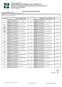
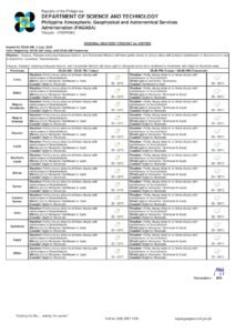
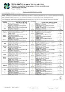
According to PAGASA, the agency’s Visayas regional weather bulletin was released at 5:00 AM on July 5, 2026, describing conditions across the region as partly cloudy to at times cloudy, with rainshowers and thunderstorms expected to develop throughout the day. Temperature readings will hover between a low of 26°C and a high of 32°C — warm and muggy, as is typical for the province in early July, though the periodic downpours should provide momentary relief from the heat.
PAGASA reported that winds will blow from the northeast to southeast direction at light to moderate speeds. Coastal waters surrounding the region have been rated slight to moderate, a classification that is manageable for larger vessels but warrants careful attention for smaller watercraft.
By the Numbers
- 5:00 AM, July 5, 2026 — Time PAGASA issued the Visayas regional forecast bulletin
- 9:00 AM, July 4, 2026 — Time of the extended weather outlook covering Sunday through Monday
- 26°C — Forecast low temperature for the day
- 32°C — Forecast high temperature for the day
- 0 active tropical cyclone wind signals — No storm signals in effect over Negros Oriental or the Visayas
- 0 gale warnings — No gale warnings issued as of the 5:00 AM bulletin
No Storm System Named, But Instability Remains
PAGASA’s bulletin does not attribute today’s unsettled weather to any specific named weather disturbance — no tropical cyclone, no southwest monsoon surge, and no declared low-pressure area is cited as the primary driver. Instead, the agency’s data indicates a pattern of northeast-to-southeast wind flow coupled with intermittent convective activity that is characteristic of the transitional atmospheric conditions common across the Visayas in early July.
In practical terms, PAGASA is signaling that the atmosphere over the region is sufficiently unstable to generate scattered rain and lightning at various points during the day — not because of a single large weather event bearing down on the area, but because of the inherent instability of warm, moisture-laden air during this season. Communities should take this seriously even in the absence of a named storm.
The extended weather outlook, separately issued by PAGASA at 9:00 AM on July 4, 2026, provides a broader forecast window. Conditions on Sunday mirror those of Saturday, with temperatures remaining in the 26°C to 32°C range, winds from the northeast to northwest direction at light to moderate speeds, and slight to moderate coastal conditions. Come Monday, the agency noted a wind direction shift, with winds expected to blow from the northwest to south while coastal sea states remain slight to moderate.
What to Expect Across Negros Oriental
For communities throughout Negros Oriental — spanning Dumaguete City, the coastal towns of Bayawan, Bais, and Tanjay, the fishing barangays of Dauin and Sibulan, and the inland municipalities of Guihulngan, Valencia, La Libertad, and Mabinay — the day is likely to follow a familiar convective pattern. Mornings may appear deceptively clear or only partly cloudy, but as land surfaces heat up through midday, moist air rises, cloud masses build rapidly, and rainshowers or thunderstorms develop in the afternoon and into the evening hours.
PAGASA’s data for nearby areas paints a consistent picture. Across the Tañon Strait toward Cebu, and across open water toward Siquijor and Bohol, the agency’s second Visayas weather area forecast shows northeast-to-east winds at light to moderate speeds, with coastal waters rated slight to moderate and rainshowers and thunderstorms likewise in the forecast.
No Active Storm Signals or Gale Warnings
As of PAGASA’s 5:00 AM bulletin for July 5, 2026, there are no active tropical cyclone wind signals and no gale warnings affecting Negros Oriental or any part of the Visayas. This distinction is important: today’s weather, while wet and at times stormy, does not carry the sustained destructive winds or dangerously rough seas that accompany a typhoon or a gale event.
However, PAGASA’s forecast is clear that the absence of a wind signal does not mean conditions are risk-free. Even without a typhoon, isolated thunderstorms can produce brief but intense bursts of heavy rain, locally gusty winds, dangerous lightning, and sharply reduced visibility — hazards that demand common-sense precautions regardless of the lack of a formal storm warning.
Guidance for Different Sectors
Ferry Passengers and Inter-Island Travelers
The sea routes connecting Dumaguete to Siquijor, Dumaguete to Dapitan in Zamboanga del Norte, and Cebu via the Tañon Strait fall under coastal waters rated slight to moderate by PAGASA. Larger vessels — including OceanJet fast crafts and roll-on, roll-off (RORO) ferries — generally operate within these conditions, but passengers should be prepared for noticeable wave action, particularly on open-water crossings. Those prone to seasickness are advised to take appropriate medication before boarding.
Small bancas and outrigger boats face a higher risk. PAGASA’s slight-to-moderate rating, combined with the possibility of passing thunderstorms intensifying wind and wave action with little warning, makes open-sea travel in small watercraft inadvisable unless absolutely necessary. The Philippine Coast Guard issues vessel departure advisories that travelers should consult before any sea journey today.
Fishing Communities Along the Coast
For fisherfolk in Bayawan, Bais, Tanjay, Dauin, Sibulan, and other coastal barangays of Negros Oriental, PAGASA’s thunderstorm forecast introduces a critical hazard beyond the general sea state: lightning at sea. Localized squalls accompanying thunderstorm cells can push winds and waves far beyond what small fishing boats can safely manage, and they can develop with very little warning. Fisherfolk who venture out early under relatively calm skies should monitor cloud formations and wind shifts carefully, and return to shore well ahead of any approaching storm — not after rain has already begun to fall.
Farmers in Upland and Interior Areas
For those tending rice paddies, sugarcane, and vegetable plots in the upland barangays of Guihulngan, Valencia, La Libertad, and Mabinay, today’s forecast rainfall carries both benefit and risk. Consistent moisture is generally favorable for crops in the vegetative stage, but intense, short-duration bursts from convective thunderstorms can cause localized flooding in low-lying fields, accelerate soil erosion on slopes, and damage standing crops physically. According to PAGASA’s forecast pattern, these heavier bursts are most likely during the afternoon and early evening.
Farmers are strongly advised to avoid open-field work during active thunderstorm periods. Lightning is a real and serious danger in open agricultural areas. Pesticide or fertilizer applications should also be deferred, as rainfall during or after application renders these treatments ineffective.
Commuters and Urban Residents in Dumaguete
City residents and commuters in Dumaguete should anticipate wet afternoon and evening conditions, with the potential for flooded low-lying streets if rainfall is heavy and sustained. Parents picking up schoolchildren or attending afternoon events should allow additional travel time. Rain gear — umbrellas, raincoats, and waterproof bags for documents and electronics — is essential for anyone heading out today. Outdoor events and activities, particularly those scheduled for the afternoon, should have contingency plans in place or consider postponement if organizers determine conditions are unsuitable.
Why This Matters
PAGASA’s forecast of scattered rainshowers and thunderstorms across Negros Oriental and the broader Visayas on July 5, 2026, affects the daily safety and livelihoods of a wide cross-section of the population — from fisherfolk and ferry passengers navigating coastal waters rated slight to moderate, to farmers managing crops vulnerable to convective downpours, and urban commuters dealing with flooded streets. While no tropical cyclone wind signals or gale warnings are in effect, the agency’s data makes clear that thunderstorm-associated hazards — including lightning, gusty squalls, and intense short-duration rainfall — remain real risks that warrant preparation. Timely awareness of PAGASA forecasts enables communities to make informed decisions that protect both safety and economic activity.
Source: breakingnewsnegrosoriental.com / PAGASA Visayas Regional Weather Forecast, July 5, 2026