Overcast skies and periodic downpours are in store for the Visayas this Saturday, June 6, 2026, after the Philippine Atmospheric, Geophysical and Astronomical Services Administration (PAGASA) released a forecast calling for partly cloudy to cloudy conditions, rainshowers, and thunderstorms across the region. The bulletin, issued at 5:00 AM Saturday, signals that residents and travelers from Negros Oriental to neighboring islands should brace for an unsettled day — and a wet weekend ahead.
The forecast is not limited to a single province or locality. The PAGASA Visayas Regional Forecast covers the breadth of the island group, meaning communities throughout Negros Oriental — from the urban center of Dumaguete City to the coastal towns of Bayawan and Bais, the agricultural interior of Guihulngan and La Libertad, and the island municipality of Siquijor — are all within the affected area.
Forecast Details for Saturday, June 6
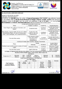
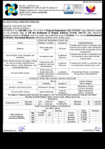
According to PAGASA’s 5:00 AM bulletin for June 6, 2026, the Visayas region should expect partly cloudy to at times cloudy skies, with rainshowers and thunderstorms occurring at various points throughout the day. Temperature readings are projected to fall between 27°C and 33°C — warm enough for the season but moderated by cloud cover and intermittent rainfall.
Wind direction, PAGASA noted, will run from the southwest to southeast at light to moderate speeds. This pattern aligns with the habagat, or southwest monsoon, which typically asserts itself over the Visayas beginning in June and brings sustained periods of moisture and rainfall to the region throughout the wet season.
Coastal sea conditions around Negros Oriental are classified as slight to moderate by PAGASA, indicating manageable wave heights but not entirely calm waters. Passengers planning to use inter-island ferry services — including vessels on the Dumaguete–Cebu, Dumaguete–Siquijor, and Dumaguete–Bohol routes operated by carriers such as OceanJet and other sea transport providers — are urged to coordinate with their operators before departing, as thunderstorm activity can rapidly deteriorate sea conditions with little warning.
Weekend Outlook: No Quick End to the Rain
The wet weather is expected to carry beyond Saturday. The PAGASA Extended Weather Outlook, released at 9:00 AM on June 5, 2026, projects a continuation of similar conditions through Friday, Saturday, and Sunday of the coming days, with temperatures ranging from 26°C to 33°C and the same light-to-moderate southwest-to-southeast wind flow in place.
Coastal sea states are also forecast to remain at the slight-to-moderate level throughout this extended period, according to PAGASA. This sustained pattern points to recurring bouts of rain and thunderstorm activity rather than an isolated weather episode, meaning communities and livelihoods that depend on fair weather will need to plan around an extended stretch of unsettled conditions.
Consequences for Farmers and Agricultural Workers
In the upland and interior farming communities of Negros Oriental — including the towns of Guihulngan, La Libertad, and other municipalities where sugarcane, rice, and vegetable cultivation are central to local economies — the forecast carries mixed implications. Rainfall during the planting season is generally beneficial for crop growth, but persistent downpours and thunderstorm activity can damage young plants, cause soil erosion, waterlog fields, and make farm roads impassable.
Agricultural workers are advised by PAGASA to consult the agency’s farm weather forecasts, which are published on its official website and offer more crop-specific weather guidance for the ongoing wet pattern affecting the Visayas.
Fisherfolk in the coastal barangays of Bayawan, Bais, Tanjay, and along Siquijor’s coastline face their own set of risks. While the slight-to-moderate coastal sea rating does not amount to a formal gale or storm signal, PAGASA’s forecast of thunderstorm potential means that conditions at sea can shift abruptly. Small-vessel operators — particularly those using bangka-type boats or outrigger craft — are strongly cautioned to remain close to shore or avoid going out altogether when thunderstorms are developing or moving through the area, as squalls can bring sudden gusts and dangerous lightning over open water.
Ferry Travel and Inter-Island Connections
Negros Oriental’s inter-island routes are among the more frequently used sea connections in the Visayas, with regular vessels linking Dumaguete to Cebu, Siquijor, and Bohol. While PAGASA’s coastal sea rating for Saturday remains at the slight-to-moderate level — not yet a threshold that automatically grounds vessels — the presence of thunderstorm activity in the forecast introduces an element of unpredictability that travelers must account for.
The Philippine Coast Guard, along with private ferry operators, holds the authority to modify or cancel sailings at short notice when weather deteriorates beyond safe operating conditions. Passengers are advised to confirm departure schedules directly with their carriers before heading to the port, and to allow room in their travel plans for potential delays. This applies especially to those traveling to or from Siquijor, which has no road connection to the main island and relies entirely on sea and air transport for access.
Thunderstorm Safety: What to Do
PAGASA’s inclusion of thunderstorm potential in the regional forecast serves as a reminder that even broadly described weather patterns can produce locally severe conditions. The following safety practices are recommended during thunderstorm episodes:
Go indoors at the first sign of lightning or thunder. Lightning frequently precedes heavy rainfall, and waiting for the downpour to begin before seeking shelter leaves a dangerous gap in safety. Avoid elevated, open, or exposed locations — including hilltops, ridgelines, open fields, and bodies of water — while thunderstorms are active.
Prepare for intense, short-duration rainfall. Thunderstorms over the Visayas are capable of delivering heavy, concentrated precipitation within a brief window, which can cause flash flooding in low-lying urban areas and along drainage channels. In Dumaguete City, barangays known to be flood-prone during heavy rain events should be monitored closely by residents and local officials.
Secure loose items on your property, especially in coastal areas and upland communities where strong gusts accompanying thunderstorm cells can dislodge unsecured materials, lightweight roofing, signage, and outdoor structures.
Motorists traversing mountain roads — including segments of the Negros Oriental circumferential highway and elevated routes through Valencia, the Casaroro area, and other highland sections — should reduce speed and heighten alertness during and after rainfall, as wet pavement, landslide debris, and reduced visibility are all elevated risks under this forecast.
Monitoring and Official Advisories
Weather patterns in tropical environments are subject to rapid change, and a regional forecast does not capture every localized development. PAGASA issues updated bulletins multiple times each day, and residents across the Visayas are encouraged to revisit these updates regularly — particularly during periods of active convective weather. All official forecast materials, including the Visayas Regional Forecast and Extended Weather Outlook referenced in this article, are available through PAGASA’s website at pagasa.dost.gov.ph.
In addition to PAGASA, the Provincial Disaster Risk Reduction and Management Office (PDRRMO) of Negros Oriental issues weather-related advisories and emergency guidance during significant weather events. Residents are encouraged to remain connected to both national and local official channels for the most current information throughout the weekend.
Originally reported by: breakingnewsnegrosoriental.com